Chili, Wisconsin facts for kids
Quick facts for kids
Chili, Wisconsin
|
|
|---|---|
|
Census-designated place
|
|

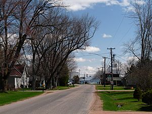
Facing east on Chili Road toward downtown
|
|
| Country | United States |
| State | Wisconsin |
| County | Clark |
| Town | Fremont |
| Area | |
| • Total | 1.301 sq mi (3.37 km2) |
| • Land | 1.287 sq mi (3.33 km2) |
| • Water | 0.014 sq mi (0.04 km2) |
| Elevation | 1,234 ft (376 m) |
| Population
(2010)
|
|
| • Total | 226 |
| • Density | 173.7/sq mi (67.07/km2) |
| Time zone | UTC-6 (Central (CST)) |
| • Summer (DST) | UTC-5 (CDT) |
| ZIP code |
54420
|
| Area code(s) | 715 & 534 |
| GNIS feature ID | 1563021 |
Chili is a small community located in Clark County, Wisconsin, in the United States. It is an area identified by the government for gathering population data, known as a census-designated place. Chili is found west-southwest of Marshfield. It has its own post office and a ZIP code of 54420. In 2010, the population of Chili was 226 people.
Contents
History of Chili, Wisconsin
How Chili Got Its Name
Around the year 1880, the Chicago and North Western Railway built a railroad line through this part of Clark County. This was done to help local sawmills transport their wood. There was a sawmill near a railroad stop called Cedarhurst. Another large sawmill was built where Chili is today.
One very cold day in the winter of 1881, railroad officials were on a train. They needed to choose a name for this new stop. It was so cold that they did not want to leave the train. One person is said to have joked, "Let's call this stop Chili because it is really chilly here!" This story is one idea for how the community got its name.
Another Idea for the Name
Another story suggests that the community was named after the country Chile in South America. Both stories are interesting ways to think about the origin of the name.
Chili's Post Office
A post office has been operating in Chili since 1892. This means the community has had a way to send and receive mail for over a century.
See also
 In Spanish: Chili (Wisconsin) para niños
 | Selma Burke |
 | Pauline Powell Burns |
 | Frederick J. Brown |
 | Robert Blackburn |


