Amery, Wisconsin facts for kids
Quick facts for kids
Amery, Wisconsin
|
|
|---|---|

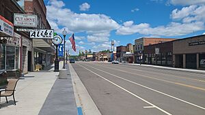
Downtown Amery
|
|

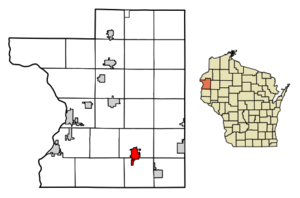
Location within Polk County and Wisconsin
|
|
| Country | United States |
| State | Wisconsin |
| County | Polk |
| Area | |
| • Total | 3.84 sq mi (9.94 km2) |
| • Land | 3.10 sq mi (8.02 km2) |
| • Water | 0.74 sq mi (1.92 km2) |
| Elevation | 1,070 ft (326 m) |
| Population
(2020)
|
|
| • Total | 2,962 |
| • Density | 907.98/sq mi (350.54/km2) |
| Time zone | UTC-6 (Central (CST)) |
| • Summer (DST) | UTC-5 (CDT) |
| Area codes | 715 & 534 |
| FIPS code | 55-01725 |
| GNIS feature ID | 1560828 |
| Website | http://www.amerywisconsin.org |
Amery (pronounced AY-mər-ee) is a city in Polk County, Wisconsin, United States. It is located along the Apple River. Amery is part of Wisconsin's 7th congressional district. In 2010, the city had a population of 2,902 people. The city was named after William Amery, a carpenter who held several local government jobs in the 1870s.
Contents
Where is Amery Located?
Amery is found at 45.309747 degrees North latitude and -92.362782 degrees West longitude.
According to the United States Census Bureau, the city covers a total area of about 3.61 square miles (9.35 square kilometers). Most of this area, about 2.96 square miles (7.67 square kilometers), is land. The remaining 0.65 square miles (1.68 square kilometers) is water.
The main roads in Amery are Wisconsin Highway 46 and Polk County Road F.
What is Amery's Climate Like?
| Climate data for Amery, Wisconsin (1991–2020 normals, extremes 1922–present) | |||||||||||||
|---|---|---|---|---|---|---|---|---|---|---|---|---|---|
| Month | Jan | Feb | Mar | Apr | May | Jun | Jul | Aug | Sep | Oct | Nov | Dec | Year |
| Record high °F (°C) | 54 (12) |
60 (16) |
80 (27) |
90 (32) |
104 (40) |
102 (39) |
108 (42) |
101 (38) |
103 (39) |
89 (32) |
76 (24) |
61 (16) |
108 (42) |
| Mean daily maximum °F (°C) | 21.5 (−5.8) |
26.9 (−2.8) |
39.5 (4.2) |
53.9 (12.2) |
67.1 (19.5) |
76.4 (24.7) |
80.7 (27.1) |
78.7 (25.9) |
70.7 (21.5) |
56.4 (13.6) |
40.2 (4.6) |
26.9 (−2.8) |
53.2 (11.8) |
| Daily mean °F (°C) | 12.7 (−10.7) |
17.2 (−8.2) |
29.8 (−1.2) |
43.4 (6.3) |
56.3 (13.5) |
65.9 (18.8) |
70.4 (21.3) |
68.3 (20.2) |
60.2 (15.7) |
46.3 (7.9) |
32.2 (0.1) |
19.3 (−7.1) |
43.5 (6.4) |
| Mean daily minimum °F (°C) | 3.9 (−15.6) |
7.4 (−13.7) |
20.1 (−6.6) |
32.9 (0.5) |
45.6 (7.6) |
55.4 (13.0) |
60.1 (15.6) |
57.8 (14.3) |
49.6 (9.8) |
36.3 (2.4) |
24.2 (−4.3) |
11.6 (−11.3) |
33.7 (0.9) |
| Record low °F (°C) | −46 (−43) |
−46 (−43) |
−40 (−40) |
−10 (−23) |
18 (−8) |
29 (−2) |
31 (−1) |
31 (−1) |
22 (−6) |
8 (−13) |
−22 (−30) |
−43 (−42) |
−46 (−43) |
| Average precipitation inches (mm) | 1.07 (27) |
1.14 (29) |
1.73 (44) |
3.04 (77) |
3.86 (98) |
4.80 (122) |
4.62 (117) |
4.16 (106) |
3.68 (93) |
3.06 (78) |
1.88 (48) |
1.50 (38) |
34.54 (877) |
| Average precipitation days (≥ 0.01 in) | 7.5 | 6.2 | 7.7 | 10.0 | 12.4 | 13.0 | 11.2 | 10.4 | 10.3 | 10.5 | 7.4 | 8.8 | 115.4 |
| Source: NOAA | |||||||||||||
Amery experiences a wide range of temperatures throughout the year. Summers are generally warm, while winters can be very cold, with temperatures sometimes dropping far below freezing. The area also receives a good amount of rain and snow.
How Many People Live in Amery?
| Historical population | |||
|---|---|---|---|
| Census | Pop. | %± | |
| 1890 | 451 | — | |
| 1900 | 905 | 100.7% | |
| 1910 | 659 | −27.2% | |
| 1920 | 1,203 | 82.5% | |
| 1930 | 1,354 | 12.6% | |
| 1940 | 1,461 | 7.9% | |
| 1950 | 1,625 | 11.2% | |
| 1960 | 1,769 | 8.9% | |
| 1970 | 2,126 | 20.2% | |
| 1980 | 2,404 | 13.1% | |
| 1990 | 2,657 | 10.5% | |
| 2000 | 2,845 | 7.1% | |
| 2010 | 2,902 | 2.0% | |
| 2019 (est.) | 2,812 | −3.1% | |
| U.S. Decennial Census | |||
Population in 2010
In 2010, the city of Amery had 2,902 residents. There were 1,286 households and 705 families living in the city. The population density was about 980 people per square mile (378 people per square kilometer).
Most of the people living in Amery were White (97.3%). A small number of residents were Native American (0.8%), Asian (0.3%), or from other backgrounds. About 2.2% of the population identified as Hispanic or Latino.
The average age of people in Amery was 45.1 years old. About 22.9% of residents were under 18 years old, and 27.6% were 65 years or older. There were more females (55.4%) than males (44.6%) in the city.
Education in Amery
Students in Amery attend schools that are part of the Amery School District.
Transportation in Amery
The Amery Municipal Airport (KAHH) is located near Amery. This airport helps people travel to and from the city by air.
Notable People from Amery
Many interesting people have connections to Amery. Here are a few:
- Jerry M. Anderson, an educator
- Ed Barney, a professional baseball player
- Dougald D. Kennedy, a Wisconsin State Representative
- Ethan B. Minier, a Wisconsin State Representative and lawyer
- Alicia Monson, an Olympic long-distance runner
- William Nordeen, a United States diplomat
- Harvey Stower, a Wisconsin State Representative and former Mayor of Amery
- Dwight York, a stand-up comedian
Images for kids
See also
 In Spanish: Amery (Wisconsin) para niños
 | Aurelia Browder |
 | Nannie Helen Burroughs |
 | Michelle Alexander |


