Benton County, Minnesota facts for kids
Quick facts for kids
Benton County
|
||
|---|---|---|

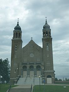
Church of Saints Peter and Paul in Gilman, Minnesota.
|
||
|
||

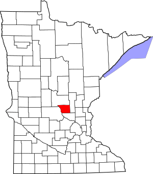
Location within the U.S. state of Minnesota
|
||
 Minnesota's location within the U.S. |
||
| Country | ||
| State | ||
| Founded | October 27, 1849 (created) 1850 (organized) |
|
| Named for | Thomas Hart Benton | |
| Seat | Foley | |
| Largest city | Sauk Rapids | |
| Area | ||
| • Total | 413 sq mi (1,070 km2) | |
| • Land | 408 sq mi (1,060 km2) | |
| • Water | 4.8 sq mi (12 km2) 1.2%% | |
| Population
(2020)
|
||
| • Total | 41,379 | |
| • Estimate
(2023)
|
41,600 |
|
| • Density | 97.9/sq mi (37.8/km2) | |
| Time zone | UTC−6 (Central) | |
| • Summer (DST) | UTC−5 (CDT) | |
| Congressional district | 6th | |
Benton County is a county located in the central part of Minnesota, a state in the United States. In 2020, about 41,379 people lived here. The main town, or county seat, where the county government is, is Foley.
Benton County is also part of the larger St. Cloud area. This area connects to the even bigger Minneapolis-St. Paul area.
Contents
History of Benton County
Benton County was created in 1849 and officially started in 1850. This makes it one of the oldest counties in Minnesota. It was named after Thomas Hart Benton. He was a famous United States Senator from Missouri.
For many years, the county seat was Sauk Rapids. This town is located where the Sauk River meets the Mississippi River. In 1856, the county seat moved to Watab, but it returned to Sauk Rapids in 1859.
A railroad line reached Sauk Rapids in 1874. However, a strong tornado destroyed the town in 1886. Because of this, the county seat moved to Foley in 1897. Foley has been the county seat ever since. As the city of St. Cloud grew, the southern part of Benton County became a suburban area.
Geography of Benton County
Benton County covers about 413 square miles (1,070 km²). Most of this area, 408 square miles (1,057 km²), is land. The rest, about 4.8 square miles (12 km²), is water. This means about 1.2% of the county is water. It is one of the smaller counties in Minnesota.
The Mississippi River flows along the western edge of Benton County. The Platte River also flows through the northwest part of the county. It joins the Mississippi River at the western border. The land here has gentle hills and is covered with forests or farms. The highest point in the county is a small hill near the northern border. It is about 1,311 feet (400 meters) above sea level.
Main Roads in Benton County
These are some of the major highways that go through Benton County:
Neighboring Counties
Benton County shares its borders with these other counties:
- Mille Lacs County to the east
- Sherburne County to the south
- Stearns County to the west
- Morrison County to the north
Lakes in Benton County
You can find these lakes in Benton County:
- Donovan Lake (part)
- Graham Lake
- Little Rock Lake
- Mayhew Lake
Protected Natural Areas
Benton County has several protected areas where nature is preserved:
- Benlacs State Wildlife Management Area (part)
- Bibles State Wildlife Management Area
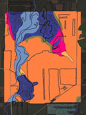
- Englund Ecotone Scientific and Natural Area
- Sartell State Wildlife Management Area
- Wisneski State Wildlife Management Area
Climate and Weather in Benton County
| Weather chart for Foley, Minnesota | |||||||||||||||||||||||||||||||||||||||||||||||
|---|---|---|---|---|---|---|---|---|---|---|---|---|---|---|---|---|---|---|---|---|---|---|---|---|---|---|---|---|---|---|---|---|---|---|---|---|---|---|---|---|---|---|---|---|---|---|---|
| J | F | M | A | M | J | J | A | S | O | N | D | ||||||||||||||||||||||||||||||||||||
|
0.7
21
2
|
0.6
27
7
|
1.6
39
20
|
2.6
56
33
|
3
69
44
|
4.2
78
54
|
3.3
82
59
|
3.8
80
56
|
3.5
70
47
|
2.5
57
35
|
1.4
39
22
|
0.8
25
7
|
||||||||||||||||||||||||||||||||||||
| temperatures in °F precipitation totals in inches source: The Weather Channel |
|||||||||||||||||||||||||||||||||||||||||||||||
|
Metric conversion
|
|||||||||||||||||||||||||||||||||||||||||||||||
The weather in Benton County changes a lot throughout the year. In Foley, the county seat, average temperatures are around 2°F (about -17°C) in January. In July, they can reach about 82°F (about 28°C).
The coldest temperature ever recorded was -43°F (-42°C) in January 1977. The hottest was 107°F (42°C) in July 1936. The county usually gets the most rain in June, about 4.17 inches (10.6 cm). February is the driest month, with about 0.62 inches (1.6 cm) of precipitation.
Population of Benton County
| Historical population | |||
|---|---|---|---|
| Census | Pop. | %± | |
| 1850 | 418 | — | |
| 1860 | 627 | 50.0% | |
| 1870 | 1,558 | 148.5% | |
| 1880 | 3,012 | 93.3% | |
| 1890 | 6,284 | 108.6% | |
| 1900 | 9,912 | 57.7% | |
| 1910 | 11,615 | 17.2% | |
| 1920 | 14,073 | 21.2% | |
| 1930 | 15,056 | 7.0% | |
| 1940 | 16,106 | 7.0% | |
| 1950 | 15,911 | −1.2% | |
| 1960 | 17,287 | 8.6% | |
| 1970 | 20,841 | 20.6% | |
| 1980 | 25,187 | 20.9% | |
| 1990 | 30,185 | 19.8% | |
| 2000 | 34,226 | 13.4% | |
| 2010 | 38,451 | 12.3% | |
| 2020 | 41,379 | 7.6% | |
| 2023 (est.) | 41,600 | 8.2% | |
| U.S. Decennial Census 1790-1960 1900-1990 1990-2000 2010-2020 |
|||
The population of Benton County has grown a lot over the years. In 1850, only 418 people lived here. By 2020, the population had grown to 41,379 people. This shows how the county has developed and attracted more residents over time.
Communities in Benton County
Benton County has several cities, townships, and other communities.
Cities in Benton County
These are the cities located in Benton County:
Townships in Benton County
Townships are smaller local government areas. Here are the townships in Benton County:
- Alberta
- Gilmanton
- Glendorado
- Graham
- Granite Ledge
- Langola
- Mayhew Lake
- Maywood
- Minden
- Saint George
- Sauk Rapids
- Watab
Other Communities
- Ronneby (a census-designated place)
Unincorporated Communities
These are smaller places that are not officially organized as cities or townships:
- Brennyville
- Duelm
- Fruitville
- Glendorado
- Granite Ledge
- Jakeville
- Mayhew
- North Benton
- Oak Park
- Parent
- Popple Creek
- Rum River
- Silver Corners
- Watab
Ghost Towns
These are places that used to be communities but are now abandoned:
- Estes Brook
- Minden
See also
 In Spanish: Condado de Benton (Minnesota) para niños
 | Madam C. J. Walker |
 | Janet Emerson Bashen |
 | Annie Turnbo Malone |
 | Maggie L. Walker |


