Ronneby, Minnesota facts for kids
Quick facts for kids
Ronneby
|
|
|---|---|

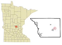
Location of the community of Ronneby
within Maywood Township, Benton County |
|
| Country | United States |
| State | Minnesota |
| County | Benton |
| Township | Maywood Township |
| Area | |
| • Total | 0.96 sq mi (2.50 km2) |
| • Land | 0.96 sq mi (2.50 km2) |
| • Water | 0.00 sq mi (0.00 km2) |
| Elevation | 1,116 ft (340 m) |
| Population
(2020)
|
|
| • Total | 71 |
| • Density | 73.73/sq mi (28.46/km2) |
| Time zone | UTC-6 (Central (CST)) |
| • Summer (DST) | UTC-5 (CDT) |
| ZIP code |
56329 and 56357
|
| Area code(s) | 320 |
| FIPS code | 27-55366 |
| GNIS feature ID | 2628690 |
Ronneby is a small community in Minnesota, United States. It is located in Benton County, within Maywood Township. Ronneby is known as an "unincorporated community" and a "census-designated place" (CDP). This means it's a recognized area, but it doesn't have its own city government.
In 2010, about 67 people lived in Ronneby. By 2020, the population grew slightly to 71 people. The community is found along State Highway 23, close to Benton County Road 6. Nearby towns include Foley and Oak Park. Ronneby is also part of the larger Saint Cloud area.
History of Ronneby
Ronneby was officially formed on August 31, 1899. It was first called Saint Francis. However, its name changed when a post office was set up in 1897. The name Saint Francis was already being used by another place. So, they chose Ronneby instead. The community had its own post office from 1897 until 1973.
In the early 1900s, Ronneby was a busy place. It had a hotel, a newspaper, a lumber mill, and three stores. It was even an official city until May 4, 2009. In November 2008, the people living there voted to stop being a city. The vote was 18 to 9 in favor of dissolving the city. They had tried to do this before in 1998, but it didn't work out because the rules weren't followed. After the 2009 vote, Ronneby became part of Maywood Township.
The population of Ronneby has changed a lot over the years. In 1900, there were 156 people. By 2000, only 16 people lived there. Then, it grew to 67 in 2010 and 71 in 2020.
Ronneby was named after a town in Sweden. That Swedish town is also called Ronneby. It is located near Karlskrona, by the Ronneby River and the Baltic Sea.
Geography of Ronneby
Ronneby covers an area of about 1 square mile (2.5 square kilometers). All of this area is land, with no large bodies of water.
The community is located within two specific parts of Maywood Township, called sections 19 and 20. A river branch, known as the West Branch of the St. Francis River, flows through Ronneby.
Population Changes
The number of people living in Ronneby has varied over time. Here is a look at its population through the years:
| Historical population | |||
|---|---|---|---|
| Census | Pop. | %± | |
| 1900 | 156 | — | |
| 1910 | 132 | −15.4% | |
| 1920 | 76 | −42.4% | |
| 1930 | 75 | −1.3% | |
| 1940 | 107 | 42.7% | |
| 1950 | 72 | −32.7% | |
| 1960 | 84 | 16.7% | |
| 1970 | 59 | −29.8% | |
| 1980 | 56 | −5.1% | |
| 1990 | 58 | 3.6% | |
| 2000 | 16 | −72.4% | |
| 2010 | 67 | 318.8% | |
| 2020 | 71 | 6.0% | |
| U.S. Decennial Census | |||
People in Ronneby
In 2000, there were 16 people living in Ronneby. These people made up 6 households, and 3 of those were families. The average number of people in each household was about 2.67. For families, the average was 3.67 people.
The age groups in Ronneby in 2000 were:
- 31.3% were under 18 years old.
- 18.8% were between 18 and 24 years old.
- 12.5% were between 25 and 44 years old.
- 18.8% were between 45 and 64 years old.
- 18.8% were 65 years or older.
The median age in Ronneby was 28 years. This means half the people were younger than 28 and half were older.
The average income for a household in the city was $40,625. For families, the average income was $31,250.
See also
 In Spanish: Ronneby (Minnesota) para niños
 | Anna J. Cooper |
 | Mary McLeod Bethune |
 | Lillie Mae Bradford |

