
Sartell, Minnesota facts for kids
Quick facts for kids
Sartell
|
||
|---|---|---|
 |
||
|
||
| Motto(s):
"A Great Place To Live"
|
||

|
||
| Country | United States | |
| State | Minnesota | |
| Counties | Stearns, Benton | |
| Incorporated | 1907 | |
| Area | ||
| • Total | 10.42 sq mi (27.00 km2) | |
| • Land | 10.16 sq mi (26.33 km2) | |
| • Water | 0.26 sq mi (0.67 km2) | |
| Elevation | 1,037 ft (316 m) | |
| Population
(2020)
|
||
| • Total | 19,351 | |
| • Estimate
(2022)
|
19,696 | |
| • Density | 1,903.69/sq mi (734.98/km2) | |
| Time zone | UTC-6 (Central (CST)) | |
| • Summer (DST) | UTC-5 (CDT) | |
| ZIP code |
56377
|
|
| Area code(s) | 320 | |
| FIPS code | 27-58612 | |
| GNIS feature ID | 2396539 | |
Sartell is a city in Minnesota, a state in the United States. It is located in both Benton and Stearns Counties. The city is special because it sits right on the Mississippi River.
Sartell is part of the larger St. Cloud area. In 2020, about 19,351 people lived there. This makes Sartell the biggest suburb of St. Cloud and the fourth-largest city in central Minnesota.
Contents
History of Sartell
Sartell has a rich history, starting long before it became a city.
Early Native American History
The first people known to live in the Sartell area were the Dakota tribe. Later, the Anishinaabe people moved into the region. The area that became Sartell was often a "no man's land" between these two tribes. This means it was a neutral zone where neither tribe fully settled.
European explorers and traders, like Jean-Baptiste Perrault and David Thompson, traveled through this area. American explorers such as Zebulon Pike and Henry Schoolcraft also explored the Mississippi River here.
The Watab Creek in Sartell was an important border. It separated the Anishinaabe people to the north from the Dakota people to the south. The U.S. government officially recognized this border in a treaty in 1825.
The Ho-Chunk People and Early Settlements
In 1846, about 1,300 Ho-Chunk people (also known as Winnebago) were moved to the Sartell area. They were placed there to act as a buffer between the Dakota and Anishinaabe tribes, who were often at war. However, the Ho-Chunk people did not stay long. They moved away in 1853 to a more peaceful area.
The Sartell area was known as "Winnebago" on maps from the 1860s.
Founding of the Town
Sartell began as a small town focused on lumber and paper. Early French fur traders called this spot "The Third Rapids" because it was the third set of rough waters they found when traveling north on the Mississippi River.

One of the first European settlers was Joseph B. Sartell, who arrived in 1854. He worked at a local sawmill. Later, he opened a flour mill and started the Sartell Brothers Lumber Company with his sons.
In 1905, construction began on the Sartell Pulp and Paper Company and the Sartell Dam across the Mississippi River. Both were finished in 1907. The paper mill became the city's biggest employer for many years.
Becoming a City
In 1907, the people living in the town decided to officially make it a village. They named it "The Village of Sartell" to honor Joseph Sartell and his family's contributions. For many years, members of the Sartell family were involved in the local government.
In 1973, a state law changed all villages in Minnesota to "cities." So, "The Village of Sartell" became "The City of Sartell."
The city has grown a lot over the years. In 1960, only about 700 people lived there. Today, the population is over 18,000!
Economy of Sartell
Sartell's economy has changed over time. For many years, the biggest employers were the paper mill (which started as Watab Pulp & Paper) and DeZurik Water Controls, a company that makes valves.
In 2012, the paper mill was badly damaged and eventually closed. Since then, Sartell has been growing and adding new businesses. It is developing a new area with larger chain stores, which is becoming a new downtown for the city.
Religion in Sartell
The Sartell family helped start the first church in town, Riverside Presbyterian. This church served the local Protestant community.
Saint Francis Xavier Church, a Roman Catholic church, was founded in 1948. It was named after Francis Xavier Pierz, a missionary who helped bring many European farmers to the area.
Transportation in Sartell
Getting around Sartell is mainly done by roads. The main roads are U.S. Highway 10 and Minnesota State Highway 15. These roads run along the edges of the city.
Sartell also has a bus service called St. Cloud Metro Bus. This bus connects Sartell to nearby cities like Sauk Rapids and St. Cloud.
Because Sartell is close to St. Cloud, residents can easily get to the St. Cloud Regional Airport. There are also Amtrak train and Greyhound bus stations in St. Cloud.
The Mississippi River in Sartell is not used for large shipping because of dams and shallow areas. However, it is popular for recreational activities like boating. The Sartell Bridge, built in 1984, helps people cross the river.
Geography of Sartell
Sartell covers an area of about 10.05 square miles (27.00 square kilometers). Most of this area is land, with a small part being water.
The city is located right on the Mississippi River. The areas around the city that are not developed are mostly woodlands and farmland. Sartell is located just north of the city of St. Cloud.
Population Changes in Sartell
| Historical population | |||
|---|---|---|---|
| Census | Pop. | %± | |
| 1910 | 240 | — | |
| 1920 | 510 | 112.5% | |
| 1930 | 521 | 2.2% | |
| 1940 | 532 | 2.1% | |
| 1950 | 662 | 24.4% | |
| 1960 | 791 | 19.5% | |
| 1970 | 1,323 | 67.3% | |
| 1980 | 3,427 | 159.0% | |
| 1990 | 5,393 | 57.4% | |
| 2000 | 9,641 | 78.8% | |
| 2010 | 15,876 | 64.7% | |
| 2020 | 19,351 | 21.9% | |
| 2022 (est.) | 19,696 | 24.1% | |
| U.S. Decennial Census 2020 Census |
|||
Sartell has grown a lot over the years. In 1910, only 240 people lived there. By 2020, the population had grown to 19,351 people. This shows how much the city has developed over the last century.
Who Lives in Sartell?
In 2020, most people in Sartell were White (about 88.6%). There were also growing numbers of Black or African American (1.9%), Asian (2.4%), and people of two or more races (3.9%). About 2.7% of the population was Hispanic or Latino.
The average age in Sartell in 2010 was about 32.7 years old. About 30% of the residents were under 18, and about 10% were 65 or older.
Education in Sartell
Most of the schools in Sartell are part of the Sartell-St. Stephen School District. However, some parts of Sartell are in the St. Cloud Area School District or the Sauk Rapids-Rice Public Schools district.
Students in the St. Cloud school district sections of Sartell attend Westwood Elementary School, North Middle School, and Apollo High School.
Mayors of Sartell
Here is a list of the people who have served as mayor of Sartell:
- Charles Sartell, 1907–1923
- C.L. Witherell, 1924–1928, 1932–1936
- Norris Sartell, 1929–1931
- Ripley Sartell Sr, 1937–1943, 1960–1973
- Elmer Thornton, 1944–1947
- Peter Pikus, 1948–1949
- Joseph Gallus, 1950–1955
- Darrel Hurd, 1956–1959
- Tony Zakrajshek, 1974–1978
- Robert C. Bogard, 1979–1990
- Robert Pogatshnik, 1991–2006
- Tim O'Driscoll 2007–2011
- Joe Perske, 2011–2014
- Sarah Nicoll, 2015–2018
- Ryan Fitzthum, 2019–term expires 2026
Notable People from Sartell
- Al Patton, a state representative for Minnesota.
- Craig Sauer, a linebacker who played for the Minnesota Vikings.
- For All Those Sleeping, a metalcore music band.
- Kurt Sauer, a defenseman who played for the Phoenix Coyotes.
- Michael Sauer, drafted by the New York Rangers.
Images for kids
-
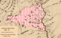
Winnebago 1846 Reservation, Nicollet's 1843 map.
-
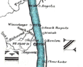
A part of a map from 1866 showing "Winnebago" (now Sartell) on the Mississippi River.

_on_the_1866_Mississippi_river_ribbon_map.png)
See also
 In Spanish: Sartell (Minnesota) para niños
