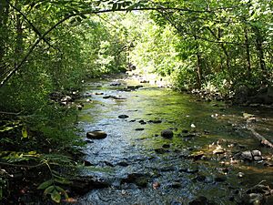
Watab River facts for kids

The Watab River, also known as Watab Creek, is a river in central Minnesota, United States. It is about 9.8 miles (15.8 kilometers) long. The Watab River is a tributary of the Mississippi River. This means it is a smaller river that flows into the larger Mississippi River. It starts in Stearns County. The river begins north of St. Joseph. It flows northeast through Watab Lake. Then it flows east and joins the Mississippi River at Sartell.
Contents
Where Does the Watab River Start?
The Watab River has two main parts that come together. These are called the North Fork and the South Fork. They meet near the town of St. Joseph. This meeting point is where the main Watab River officially begins.
The North Fork Watab River
The North Fork Watab River is about 11.1 kilometers (6.9 miles) long. It starts in a place called Island Lake. A small creek flows from Island Lake into Pflueger Lake. From there, it flows northeast to Stumpf Lake. Then it turns southeast near Collegeville. Finally, it joins the South Fork near St. Joseph.
The South Fork Watab River
The South Fork Watab River is longer, at about 20.4 kilometers (12.7 miles). It flows southeast from Big Watab Lake. It then goes through Little Watab Lake. After that, it passes through a pond. Then it flows northeast and meets the North Fork Watab River.
What's in a Name?
The name Watab comes from the Anishinaabe/Ojibwe language. The Ojibwe people are a Native American group. In their language, wadab-ziibi means "river with spruce-roots." This name was given because long ago, you could see exposed spruce tree roots along the riverbanks. The word watab itself comes from an older language called Algonquian. Watap in Algonquian refers to the strong cords. These cords were used to sew together the birch-bark panels on a canoe.
A River's History
The Watab River has been important for a long time. In 1825, it became part of a border. This border was on the west side of the Mississippi River. It separated the lands of the Anishinaabe/Ojibwe people to the north. To the south were the lands of the Dakota/Sioux people. About 20 years later, the Watab River also marked the southern boundary. This was for a special area called the Long Prairie Reservation. This reservation was for the Winnebago/Ho-Chunk people. It lasted for less than ten years.
 | Toni Morrison |
 | Barack Obama |
 | Martin Luther King Jr. |
 | Ralph Bunche |

