
Onamia, Minnesota facts for kids
Quick facts for kids
Onamia, Minnesota
|
|
|---|---|

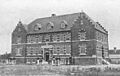
Onamia City Hall
|
|

Location in Mille Lacs County, Minnesota
|
|
| Country | United States |
| State | Minnesota |
| County | Mille Lacs |
| Area | |
| • Total | 1.00 sq mi (2.59 km2) |
| • Land | 0.98 sq mi (2.54 km2) |
| • Water | 0.02 sq mi (0.05 km2) |
| Elevation | 1,263 ft (385 m) |
| Population
(2020)
|
|
| • Total | 784 |
| • Density | 798.37/sq mi (308.23/km2) |
| Time zone | UTC-6 (Central (CST)) |
| • Summer (DST) | UTC-5 (CDT) |
| ZIP code |
56359
|
| Area code(s) | 320 |
| FIPS code | 27-48310 |
| GNIS feature ID | 0648967 |
Onamia is a small city in Mille Lacs County, Minnesota, United States. In 2020, about 784 people lived there. This was a bit less than the 878 people who lived there in 2010. The main roads that go through Onamia are U.S. Highway 169 and Minnesota State Highway 27.
Contents
History of Onamia
The city of Onamia was formed when two smaller communities joined together. These were the village of Onamia and the village of Ericksonville. The name "Onamia" comes from the Ojibwe word onaman. This word means "red ochre" or "vermilion", which is a type of red color.
Ericksonville became an official village in 1898. Onamia became an official city later, in 1908.
Geography and Location
Onamia is located in the northern part of Mille Lacs County. It sits on the south shore of Lake Onamia. This lake is only about 3 miles (5 km) south of the much larger Mille Lacs Lake.
Main Roads and Travel
- U.S. Route 169 goes through the east side of Onamia.
- State Highway 27 runs through Onamia as its Main Street.
- It goes northeast about 12 miles (19 km) to Isle, which is at the southeast end of Mille Lacs Lake.
- It heads west about 40 miles (64 km) to Little Falls, a city on the Mississippi River.
Lakes and Rivers
The city of Onamia covers about 1 square mile (2.59 square kilometers) of land and a small amount of water. Lake Onamia borders the city to the north. The Rum River flows into and out of Lake Onamia. The river's exit from the lake is in the western part of the city. The Rum River continues south to Milaca and eventually joins the Mississippi River in Anoka.
Nearby Parks and Forests
- Mille Lacs Kathio State Park is about 4 miles (6 km) northwest of Onamia.
- Parts of the Rum River State Forest are also located nearby.
Population Information
| Historical population | |||
|---|---|---|---|
| Census | Pop. | %± | |
| 1910 | 314 | — | |
| 1920 | 416 | 32.5% | |
| 1930 | 514 | 23.6% | |
| 1940 | 619 | 20.4% | |
| 1950 | 704 | 13.7% | |
| 1960 | 645 | −8.4% | |
| 1970 | 670 | 3.9% | |
| 1980 | 691 | 3.1% | |
| 1990 | 676 | −2.2% | |
| 2000 | 847 | 25.3% | |
| 2010 | 878 | 3.7% | |
| 2020 | 784 | −10.7% | |
| U.S. Decennial Census | |||
In 2010, there were 878 people living in Onamia. There were 349 households, which are groups of people living together. About 27% of these households had children under 18. The average age of people in the city was about 41.7 years old.
Education in Onamia
The public schools in Onamia are part of the Onamia Public Schools system.
There is also a tribal school called the Nay Ah Shing School. This school teaches students from kindergarten through 12th grade. It has a secondary school and a primary school facility (Abinoojiiyag School) located in an area close to the city.
Notable Person
- Shane Bauer - an author
Gallery
-
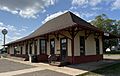
Onamia Depot Library
-
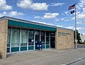
Onamia Post Office
-
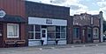
Businesses in the city
-
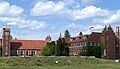
Crosier Fathers and Brothers religious community


Images for kids
-
A cloister (a covered walkway, often in a monastery) in Onamia, built in 1922.

See also
 In Spanish: Onamia (Minnesota) para niños
