Wright County, Minnesota facts for kids
Quick facts for kids
Wright County
|
|
|---|---|

|
|

Location within the U.S. state of Minnesota
|
|
 Minnesota's location within the U.S. |
|
| Country | |
| State | |
| Founded | February 20, 1855 |
| Named for | Silas Wright |
| Seat | Buffalo |
| Largest city | Otsego |
| Area | |
| • Total | 714 sq mi (1,850 km2) |
| • Land | 661 sq mi (1,710 km2) |
| • Water | 53 sq mi (140 km2) 7.4%% |
| Population
(2020)
|
|
| • Total | 141,337 |
| • Estimate
(2023)
|
151,150 |
| • Density | 213.8/sq mi (82.5/km2) |
| Time zone | UTC−6 (Central) |
| • Summer (DST) | UTC−5 (CDT) |
| Congressional district | 6th |
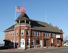
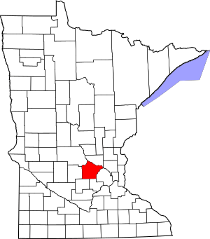
Wright County is a county located in the East Central part of Minnesota, a U.S. state. In 2020, about 141,337 people lived here. The main city and county seat is Buffalo. Wright County was started in 1855.
This county is part of the larger Minneapolis-St. Paul-Bloomington, MN-WI Metropolitan Statistical Area. Wright County is the tenth-largest county in Minnesota by population. It is also the fastest growing county in the state!
Contents
History of Wright County
Wright County was created in 1855. It was named after Silas Wright, a politician from New York. The first county seat was Monticello. Later, in 1868, the county seat was moved to Buffalo.
Many of the first people to settle in this area came from Germany and Sweden. In 1860, the county had 3,729 people. By 1875, the population had grown to 13,775. A movie called A Simple Plan was set in Wright County in 1998.
Geography and Nature
Wright County covers about 714 square miles. Most of this area, 661 square miles, is land. The other 53 square miles (about 7.4%) is water. The land here is hilly and has many small lakes. The Mississippi River forms the northeast border of the county.
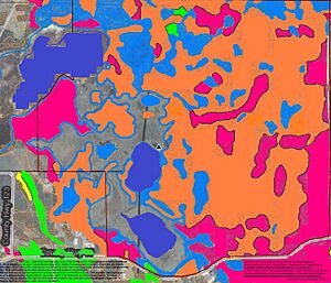
Wright County is special because it has many savanna soils. Savanna soils are a mix of prairie and forest soils. It is one of only two counties in Minnesota where savanna soils make up more than 75% of the land.
Main Roads in Wright County
Counties Nearby
Wright County shares borders with these other counties:
- Sherburne County - to the northeast
- Hennepin County - to the east
- Carver County - to the southeast
- McLeod County - to the southwest
- Meeker County - to the west
- Stearns County - to the northwest
- Anoka County - to the northeast
Population Changes in Wright County
| Historical population | |||
|---|---|---|---|
| Census | Pop. | %± | |
| 1860 | 3,729 | — | |
| 1870 | 9,457 | 153.6% | |
| 1880 | 18,104 | 91.4% | |
| 1890 | 24,164 | 33.5% | |
| 1900 | 29,157 | 20.7% | |
| 1910 | 28,082 | −3.7% | |
| 1920 | 28,685 | 2.1% | |
| 1930 | 27,119 | −5.5% | |
| 1940 | 27,550 | 1.6% | |
| 1950 | 27,716 | 0.6% | |
| 1960 | 29,935 | 8.0% | |
| 1970 | 38,933 | 30.1% | |
| 1980 | 58,681 | 50.7% | |
| 1990 | 68,710 | 17.1% | |
| 2000 | 89,986 | 31.0% | |
| 2010 | 124,700 | 38.6% | |
| 2020 | 141,337 | 13.3% | |
| 2023 (est.) | 151,150 | 21.2% | |
| U.S. Decennial Census 1790–1960 1900–1990 1990–2000 2010–2020 |
|||
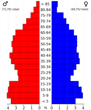
The population of Wright County has grown a lot over the years. In 2020, the county had 141,337 people. Most people in Wright County are White. There are also growing numbers of Black, Asian, and people of mixed races. About 3.32% of the population is Hispanic or Latino.
In 2000, the average household had 2.83 people. The average family had 3.26 people. About 42.10% of households had children under 18 living there. The median age in the county was 33 years old.
Cities and Towns
Wright County has many cities and smaller communities.
Cities
- Albertville
- Annandale
- Buffalo (the county seat)
- Clearwater
- Cokato
- Dayton (mostly in Hennepin County)
- Delano
- Hanover (a small part is in Hennepin County)
- Howard Lake
- Maple Lake
- Monticello
- Montrose
- Otsego
- Rockford (partly in Hennepin County)
- South Haven
- St. Michael
- Waverly
Townships
- Albion
- Buffalo
- Chatham
- Clearwater
- Cokato
- Corinna
- Franklin
- French Lake
- Maple Lake
- Marysville
- Middleville
- Monticello
- Rockford
- Silver Creek
- Southside
- Stockholm
- Victor
- Woodland
Other Communities
- Silver Creek (a census-designated place)
Other small communities that are not official cities or townships include:
- Albion Center
- Albright
- Enfield
- French Lake
- Hasty
- Highland
- Knapp
- Oster
- Rassat
- Rice Lake
- Smith Lake
- Stockholm
- West Albion
There is also one ghost town (a town that no longer exists) called Dickinson.
Largest Cities in Wright County
Here are the largest cities in Wright County based on their population in 2020:
| 2020 Rank | City | 2010 Census | 2020 Census | Percent Increase |
|---|---|---|---|---|
| 1 | Otsego | 13,571 | 19,966 | +47.12% |
| 2 | St. Michael | 16,399 | 18,235 | +11.20% |
| 3 | Buffalo | 15,453 | 18,168 | +17.57% |
| 4 | Monticello | 12,759 | 14,455 | +13.29% |
| 5 | Albertville | 7,044 | 7,896 | +12.10% |
| 6 | Delano | 5,464 | 6,484 | +18.67% |
| 7 | Rockford | 4,316 | 4,515 | +4.61% |
| 8 | Annandale | 3,228 | 3,517 | +8.95% |
| 9 | Hanover | 2,938 | 3,507 | +19.37% |
| 10 | Montrose | 2,847 | 3,317 | +16.51% |
| 11 | Cokato | 2,694 | 2,747 | +1.97% |
See also
 In Spanish: Condado de Wright (Minnesota) para niños
 | Calvin Brent |
 | Walter T. Bailey |
 | Martha Cassell Thompson |
 | Alberta Jeannette Cassell |


