Hennepin County, Minnesota facts for kids
Quick facts for kids
Hennepin County
|
|||
|---|---|---|---|
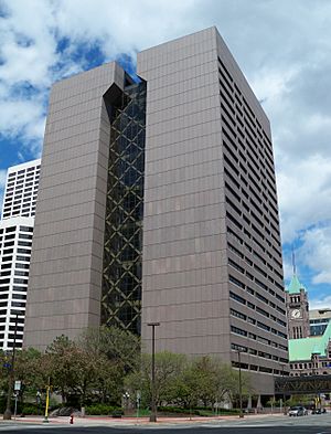
The Hennepin County Government Center, located in the county seat of Minneapolis. Its stylized letter "H" shape serves as the logo for Hennepin County.
|
|||
|
|||
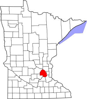
Location within the U.S. state of Minnesota
|
|||
 Minnesota's location within the U.S. |
|||
| Country | |||
| State | |||
| Founded | March 6, 1852 | ||
| Named for | Louis Hennepin | ||
| Seat | Minneapolis | ||
| Largest city | Minneapolis | ||
| Area | |||
| • Total | 607 sq mi (1,570 km2) | ||
| • Land | 554 sq mi (1,430 km2) | ||
| • Water | 53 sq mi (140 km2) 8.7%% | ||
| Population
(2020)
|
|||
| • Total | 1,281,565 | ||
| • Estimate
(2023)
|
1,258,713 |
||
| • Density | 2,111.3/sq mi (815.2/km2) | ||
| Time zone | UTC−6 (Central) | ||
| • Summer (DST) | UTC−5 (CDT) | ||
| Area code | 612, 763, 952 | ||
| Congressional districts | 3rd, 5th | ||
Hennepin County is a county in the state of Minnesota. Its main city, called the county seat, is Minneapolis. Minneapolis is also the largest city in Minnesota. The county is named after Louis Hennepin, an explorer from the 1600s.
Hennepin County stretches from Minneapolis to its many suburbs and towns in the west. It has lots of woods, hills, and lakes. In 2020, about 1.28 million people lived here. This makes it the most populated county in Minnesota. More than one out of every five people in Minnesota lives in Hennepin County. It is part of the larger Minneapolis–Saint Paul–Bloomington Metropolitan Statistical Area.
Contents
History of Hennepin County
The Minnesota government created Hennepin County on March 6, 1852. Two years later, Minneapolis became its main city. The county was named after Louis Hennepin. He was the first to name Saint Anthony Falls and write about the area for people in the Western world. In January 1855, the first bridge over the Mississippi River was built over St. Anthony Falls.
Water power helped Minneapolis and Hennepin County grow. The strong currents of rivers and streams powered many mills. These mills ground grain into flour and cut wood into lumber. By the late 1860s, over a dozen mills were busy near St. Anthony Falls. The county's population grew to more than 12,000 people.
The power from the falls connected the city to the farms. Farms grew vegetables, fruits, and grains for city people. Minneapolis industries made lumber, furniture, and clothes. By 1883, railroads connected Minneapolis to both the East and West coasts. New ways of milling flour helped the area grow fast.
Major flour companies like Washburn and Pillsbury were here. For ten years, Minneapolis was the world's flour-milling capital. It was also one of the biggest lumber producers. By 1890, Minneapolis had 165,000 people. It became a major American city. By 1900, it was the center of industry and trade in the Upper Midwest.
Farming was also very important in Hennepin County. In 1910, farms covered 284,000 acres. This was about 72% of the county's land. Farmers mainly grew wheat, corn, vegetables, and apples. This amount of farmland stayed high for 30 years. But by 1950, farming land went down to 132,000 acres. This happened as more houses and businesses were built in the suburbs.
In the 1950s and 1960s, many suburbs grew quickly. New housing, shopping centers, and factories replaced farmland. By 1970, more people lived in the suburbs than in Minneapolis itself. Minneapolis's population dropped by 10% from 1960 to 1970. Meanwhile, the suburban population grew by almost 50%.
Another big change happened in the mid-1970s. Many people came to the county after the Vietnam War. This wave of new people was largest in the 1980s. Hundreds of refugees from Southeast Asia moved to Hennepin County. Local churches often helped them settle. The county's population reached over one million people in 1989.
Geography of Hennepin County
Hennepin County covers about 607 square miles. About 554 square miles are land, and 53 square miles are water. This means about 8.7% of the county is water. Hennepin County has mostly savanna soils. These are soils found in grasslands with scattered trees.
The tallest waterfall on the Mississippi River is Saint Anthony Falls. It is in Hennepin County, near downtown Minneapolis. In the 1800s, these falls were changed into a series of dams. Now, barges and boats use locks to move past the dams on the river.
Neighboring Counties
- Anoka County (to the northeast)
- Ramsey County (to the east)
- Dakota County (to the southeast)
- Scott County (to the south)
- Carver County (to the southwest)
- Wright County (to the northwest)
- Sherburne County (to the north)
Protected Natural Areas
- Minnesota Valley National Wildlife Refuge (part of it)
- Mississippi National River and Recreation Area (part of it)
People of Hennepin County
| Historical population | |||
|---|---|---|---|
| Census | Pop. | %± | |
| 1860 | 12,849 | — | |
| 1870 | 31,566 | 145.7% | |
| 1880 | 67,013 | 112.3% | |
| 1890 | 185,294 | 176.5% | |
| 1900 | 228,340 | 23.2% | |
| 1910 | 333,480 | 46.0% | |
| 1920 | 415,419 | 24.6% | |
| 1930 | 517,785 | 24.6% | |
| 1940 | 568,899 | 9.9% | |
| 1950 | 676,579 | 18.9% | |
| 1960 | 842,854 | 24.6% | |
| 1970 | 960,080 | 13.9% | |
| 1980 | 941,411 | −1.9% | |
| 1990 | 1,032,431 | 9.7% | |
| 2000 | 1,116,200 | 8.1% | |
| 2010 | 1,152,425 | 3.2% | |
| 2020 | 1,281,565 | 11.2% | |
| 2023 (est.) | 1,258,713 | 9.2% | |
| U.S. Decennial Census 1790–1960 1900–1990 1990–2000 2010–2020 |
|||
Hennepin County has become home to many different groups of people over time. Long ago, Native American tribes like the Dakota Sioux lived here. In the early 1800s, people from Europe began to settle, mostly white people from Northern Europe.
Later, in the 1900s, more groups arrived. African Americans moved here during the Great Migration. Also, Latino, Asian, and other immigrant groups came in the second half of the century. This made the county much more diverse.
Population in 2020
In 2020, there were 1,281,565 people living in Hennepin County. The population was about 65.6% White, 13.2% Black or African American, 7.7% Hispanic or Latino, 0.6% Native American, and 7.6% Asian. About 4.8% of people were from two or more races. Also, 18% of people aged 5 or older spoke a language other than English at home.
Ancestry of Residents
Many people in Hennepin County have roots from different countries. The most common ancestries are German, Irish, English, Norwegian, and Swedish. Other groups include African, Mexican, Polish, French, and Somali.
Hennepin County is the wealthiest county in Minnesota. It is also one of the 100 highest-income counties in the United States. Besides English, many other languages are spoken here. These include Arabic, Hmong, Khmer, Lao, Russian, Somali, Spanish, and Vietnamese.
Transportation
Public Transit
Several public transportation systems serve Hennepin County. These include:
- Maple Grove Transit
- Metro Transit
- Minnesota Valley Transit Authority
- Plymouth Metrolink
- Southwest Transit
- Hawthorne Transportation Center (a bus station for companies like Flixbus and Greyhound)
Main Roads
 Interstate 35W
 Interstate 94
 Interstate 394
 Interstate 494
 Interstate 694
 US Highway 12
 US Highway 52
 US Highway 169
 US Highway 212
 Minnesota State Highway 5
 Minnesota State Highway 7
 Minnesota State Highway 41
 Minnesota State Highway 47
 Minnesota State Highway 55
 Minnesota State Highway 62
 Minnesota State Highway 65
 Minnesota State Highway 77
 Minnesota State Highway 100
 Minnesota State Highway 101
 Minnesota State Highway 121
 Minnesota State Highway 252
 Minnesota State Highway 610
 Hennepin County Road 17 (France Avenue)
 Hennepin County Road 61
 Hennepin County Road 81
 Hennepin County Road 122
- Other county roads
Airports
- Minneapolis–Saint Paul International Airport (MSP) serves the Twin Cities area. It is a very busy airport and a main hub for Delta Air Lines.
- Crystal Airport (MIC) is a public airport in Crystal.
- Flying Cloud Airport (FCM) is a public airport in Eden Prairie.
Economy
Hennepin County is the economic heart of Minnesota. Many large companies are based here. In 2018, twelve Fortune 500 companies had their main offices in Hennepin County. Five of these were in Minneapolis.
| Company Name | National Rank | Headquarters City | Industry |
|---|---|---|---|
| UnitedHealth Group | 5 | Minnetonka | Healthcare |
| Target | 39 | Minneapolis | Retail |
| Best Buy | 72 | Richfield | Electronics Retail |
| U.S. Bancorp | 122 | Minneapolis | Banking and Finance |
| SuperValu | 180 | Eden Prairie | Food Distribution |
| General Mills | 182 | Golden Valley | Food Processing |
| C.H. Robinson | 193 | Eden Prairie | Transportation |
| Ameriprise Financial | 252 | Minneapolis | Financial Services |
| Xcel Energy | 266 | Minneapolis | Electricity and Gas |
| Thrivent Financial | 343 | Minneapolis | Financial Services |
| Mosaic | 382 | Plymouth | Fertilizer Manufacturing |
| Polaris | 496 | Medina | Snowmobile Manufacturing |
Hennepin County also has big private companies. These include Carlson and Cargill, both in Minnetonka. Cargill is the largest privately owned company in the United States.
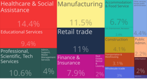
The biggest industries in Hennepin County are healthcare and social assistance, manufacturing, and retail trade.
| Employer | Number of employees | Industry |
|---|---|---|
| University of Minnesota | 18,000 | Education |
| Target Stores Inc | 10,000 | Retail |
| Pharmacy at Park Nicollet | 9,000 | Healthcare |
| Park Nicollet Methodist Hospital | 8,200 | Healthcare |
| Park Nicollet Clinic | 8,000 | Healthcare |
| M Health Fairview University of Minnesota Medical Center | 8,000 | Healthcare |
| M Health Fairview University of Minnesota Masonic Children's Hospital | 7,658 | Healthcare |
| Ameriprise Financial Inc | 7,000 | Financial Services |
| Park Nicollet Urgent Care | 7,000 | Healthcare |
| Best Buy Inc | 6,000 | Electronics Retail |
Education
Colleges and Universities
Hennepin County has many colleges and universities. Some of them are:
- Augsburg University in Minneapolis
- Dunwoody College of Technology in downtown Minneapolis
- Hennepin Technical College in Brooklyn Park and Eden Prairie
- Minneapolis College of Art and Design in Minneapolis
- Minneapolis Community and Technical College in downtown Minneapolis
- Normandale Community College in Bloomington
- North Central University in downtown Minneapolis
- North Hennepin Community College in Brooklyn Park
- University of Minnesota – Twin Cities campus in Minneapolis
- University of St. Thomas – Minneapolis campus
K–12 Schools
Many school districts serve the students in Hennepin County. Some of these are:
- Anoka-Hennepin Public School District
- Bloomington Public School District
- Brooklyn Center School District
- Edina Public School District
- Eden Prairie Public School District
- Hopkins Public School District
- Minneapolis Public School District
- Minnetonka Public School District
- Orono Public School District
- Osseo Public School District
- Richfield Public School District
- Robbinsdale Public School District
- St. Louis Park Public School District
- Wayzata Public School District
Public Libraries
The Hennepin County Library system provides books and resources for everyone. The Minneapolis Public Library also joined this system.
Fun Things to Do
Parks and Green Spaces
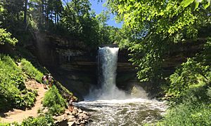
Hennepin County, especially Minneapolis, is famous for its amazing parks. The Minneapolis park system is known as one of the best designed and maintained in America. It has been named the top park system in the country many times.
Many parks in Minneapolis are connected by the Grand Rounds National Scenic Byway. This is a 51-mile long series of parks and paths. It includes famous spots like Nicollet Island, St. Anthony Falls, Stone Arch Bridge, Minnehaha Park, and several beautiful lakes like Lake Harriet and Bde Maka Ska.
Outside Minneapolis, Hennepin County is part of the Three Rivers Park District. This park system has 20 parks and 10 trails across the Twin Cities area.
Arts and Culture
Minneapolis has many art places, making Hennepin County a big center for the arts. You can find some of the country's largest art centers here. These include the Minneapolis Institute of Art, Walker Art Center, Weisman Art Museum, and the Minneapolis Sculpture Garden. There are also many artist groups and art areas in Minneapolis.
Hennepin County also has a lively theater scene. The Guthrie Theater in downtown Minneapolis is a highlight. Many theater companies perform here, like Mixed Blood and Children's Theatre Company. Other famous theaters include the Orpheum Theatre and the State Theatre. Many other cities in the county also have local community theaters.
Sports Teams
Hennepin County is home to professional sports teams. Three major league teams play in Minneapolis:
- The Minnesota Twins (baseball) play at Target Field.
- The Minnesota Timberwolves (basketball) play at Target Center.
- The Minnesota Vikings (football) play at U.S. Bank Stadium.
The Minnesota Lynx (women's basketball) also play at Target Center.
Cities in Hennepin County
- Bloomington
- Brooklyn Center
- Brooklyn Park
- Champlin
- Chanhassen (partial)
- Corcoran
- Crystal
- Dayton (partial)
- Deephaven
- Eden Prairie
- Edina
- Excelsior
- Golden Valley
- Greenfield
- Greenwood
- Hanover (partial)
- Hopkins
- Independence
- Long Lake
- Loretto
- Maple Grove
- Maple Plain
- Medicine Lake
- Medina
- Minneapolis (county seat and largest municipality)
- Minnetonka
- Minnetonka Beach
- Minnetrista
- Mound
- New Hope
- Orono
- Osseo
- Plymouth
- Richfield
- Robbinsdale
- Rockford (partial)
- Rogers
- Shorewood
- Spring Park
- St. Anthony (partial)
- St. Bonifacius
- St. Louis Park
- Tonka Bay
- Wayzata
- Woodland
Unorganized Territory
- Fort Snelling
See also
 In Spanish: Condado de Hennepin para niños
 | Sharif Bey |
 | Hale Woodruff |
 | Richmond Barthé |
 | Purvis Young |


