
Stone Arch Bridge (Minneapolis) facts for kids
Quick facts for kids Stone Arch Bridge |
|
|---|---|

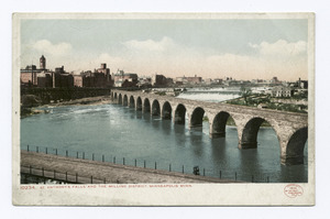
A view of the bridge from downtown Minneapolis
|
|
| Coordinates | 44°58′51″N 93°15′13″W / 44.98083°N 93.25361°W |
| Carries | Pedestrian and bicycle lanes; formerly two tracks of the Great Northern Railway |
| Crosses | Mississippi River |
| Locale | Minneapolis, Minnesota |
| Maintained by | Minneapolis Park Board |
| ID number | 27004 |
| Characteristics | |
| Design | 21 stone arch spans, plus one steel-deck truss span |
| Total length | 2100 feet (640 meters) |
| Width | 28 feet (8.5 meters) |
| Longest span | 197.5 feet (60.2 meters) (channel span) |
| Clearance below | 24.4 feet (7.4 meters) |
| History | |
| Opened | 1883 |
|
Stone Arch Bridge
|
|
|
U.S. Historic district
Contributing property |
|
| Lua error in Module:Location_map at line 420: attempt to index field 'wikibase' (a nil value). | |
| Location | Minneapolis, MN |
| Part of | St. Anthony Falls Historic District (ID71000438) |
| Designated CP | March 11, 1971 |

Bridges over the Mississippi in Minneapolis/St. Paul. Stone Arch Bridge is about center of this image, between 3rd Ave. Bridge and I-35W
|
|
The Stone Arch Bridge is a famous old railroad bridge in Minneapolis, Minnesota. It crosses the Mississippi River right at Saint Anthony Falls. This bridge is special because it's the only stone arch bridge along the entire Mississippi River. It's also the second oldest bridge on the river, after the Eads Bridge.
The bridge was built to connect the railway system to a new train station in downtown Minneapolis. It was finished in 1883 and cost about $650,000 back then. Today, that would be a lot more money!
The Stone Arch Bridge was built by a railroad boss named James J. Hill for his Great Northern Railway. For a while, people called it "Hill's Folly" because they thought it was a crazy idea. But soon, everyone saw how important it was for carrying train passengers.
Today, the bridge is no longer used for trains. Instead, it's a popular path for people to walk and ride bikes. It's considered a Historic Civil Engineering Landmark and was added to the National Register of Historic Places in 1971.
Contents
Why Was the Stone Arch Bridge Built?
In the 1880s, Minneapolis was growing fast! Most of the big businesses were on the west side of the Mississippi River. Smaller businesses were on the east side. When the village of St. Anthony joined Minneapolis, the city got even bigger.
The only way for people to cross the river was the Hennepin Avenue suspension bridge. This bridge was getting old and too busy. The city's train tracks, which were very important for moving goods and people, were mostly on the east side of the river.
Business leaders in Minneapolis needed a better way to handle all the traffic. They asked railroad expert James J. Hill for help. The idea was to build a new train station in downtown Minneapolis. This station would connect to the Manitoba Road tracks, which later became the Great Northern Railway.
How Was the Bridge Designed and Built?
Planning for the Stone Arch Bridge started in late 1881. The project included building the downtown train station and connecting the tracks. A special team called the Minneapolis Union Railway company was created just for this project.
In 1882, the team chose Col. Charles C. Smith to be the main engineer. James J. Hill first wanted an iron bridge. But Smith found that an iron bridge would harm the soft sandstone around St. Anthony Falls. So, Smith designed the unique stone arches to fit the area.
The stone for the bridge came from nearby places. The strong granite for the piers (the parts that hold up the bridge) came from Sauk Rapids. The limestone for the upper parts came from Mankato and Iowa.
The Stone Arch Bridge was built between 1882 and 1883. It took 22 months of hard work to finish!
How Has the Bridge Changed Over Time?
The Stone Arch Bridge has been updated and repaired many times since it was built.
- 1925: The bridge was made wider to allow bigger trains to cross.
- 1961-1963: The Upper Lock and Dam were built at St. Anthony Falls. This meant two of the bridge's arches had to be replaced with a movable steel section. This allowed barges to pass through the lock.
- 1965: The Mississippi River flooded, and the water caused one of the bridge's supports to sink about 14 inches. The bridge was repaired by making the supports stronger.
- 1978: The last passenger train crossed the Stone Arch Bridge. It was no longer used for railroads.
- 1994: The bridge was turned into a path for walking and biking by the Minneapolis Park Board.
The walking and biking paths on the bridge are now part of the city's park system. They are also part of the St. Anthony Falls Heritage Trail. This trail has signs that tell the history of the area. In 2005, new lights were added to the bridge, making it look beautiful at night.
What Can You Do at the Stone Arch Bridge Today?
The Stone Arch Bridge is a popular spot, especially in the summer. Many festivals happen nearby.
- The Stone Arch Festival of the Arts takes place around Father's Day. It shows off the work of many local artists.
- On the Fourth of July and during the Minneapolis Aquatennial in late July, fireworks are launched from nearby Hennepin Island. The bridge is a great place to watch them!
From the bridge, you can see amazing views of the Minneapolis skyline. You can also see the historic Pillsbury "A" Mill, the Mill City Museum, and the Guthrie Theater. There are also many restaurants nearby on Main Street SE.
Images for kids
-
A view of the bridge from downtown Minneapolis
-
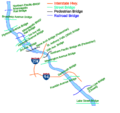
Bridges over the Mississippi in Minneapolis/St. Paul. Stone Arch Bridge is about center of this image, between 3rd Ave. Bridge and I-35W
-

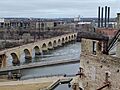
Early 20th century view of the area near the bridge
