
Richfield, Minnesota facts for kids
Quick facts for kids
Richfield
|
|
|---|---|

Corner of 66th St and Lyndale Avenue in downtown Richfield
|
|
| Motto(s):
The Urban Hometown
|
|

Location of Richfield
within Hennepin County, Minnesota |
|

Richfield, Minnesota
Location in Minnesota

Richfield, Minnesota
Location in the United States

Richfield, Minnesota
Location in North America
|
|
| Country | United States |
| State | Minnesota |
| County | Hennepin |
| Founded | 1850s |
| Incorporated | 1908 |
| Government | |
| • Type | Council-manager government |
| Area | |
| • City | 6.91 sq mi (17.91 km2) |
| • Land | 6.78 sq mi (17.55 km2) |
| • Water | 0.14 sq mi (0.35 km2) 2.00% |
| Elevation | 840 ft (256 m) |
| Population
(2020)
|
|
| • City | 36,994 |
| • Estimate
(2022)
|
36,710 |
| • Density | 5,457.95/sq mi (2,107.40/km2) |
| • Metro | 3,693,927 (US: 16th) |
| Time zone | UTC-6 (Central) |
| • Summer (DST) | UTC-5 (CDT) |
| ZIP code |
55423
|
| Area code(s) | 612 |
| FIPS code | 27-54214 |
| GNIS feature ID | 0650061 |
Richfield is a city in Hennepin County, Minnesota. It's a close neighbor to Minneapolis, located just south of it. Richfield is also next to the Minneapolis–Saint Paul International Airport and Fort Snelling to the east. To its south is Bloomington, and to its west is Edina. In 2020, about 36,994 people lived in Richfield.
Best Buy, a very large electronics store chain in the U.S., has its main office in Richfield.
Contents
History of Richfield

In the 1820s, small communities began to grow near Fort Snelling. By the late 1830s, the fort was a popular spot for new people moving to the "Minisota" area. These newcomers included lumberjacks, missionaries, farmers, and traders. One early settler was Franklin Steele, who arrived in 1837. He sold goods to soldiers at the fort.
Most people living in the area were part of Fort Snelling's military group. Other small groups of traders, farmers, and missionaries also settled outside the fort. These early residents built communities on the land that later became known as Richfield.
Richfield's Early Days
Richfield was one of the first suburbs in the Twin Cities area to grow after World War II. Many veterans returning from the war moved here. However, Richfield's history as a "suburb" goes back to the 1820s. The word "suburb" comes from a Latin word meaning "land outside a walled city." Much of the land that became Richfield Township, and later the City of Richfield, included the Fort Snelling military area. This area also contained Camp Coldwater.
Richfield Township is Formed

One of the first people to settle here was Riley Bartholomew. He was a former general from Ohio. He later became a judge and a state senator for Minnesota. In 1852, Bartholomew built a house on the east side of Wood Lake. This house, the Riley Lucas Bartholomew House, is now a historic site. The Richfield Historical Society takes care of it today.
The Harmony post office opened in 1854. It was located south of the Richland Mill on Lyndale Avenue. The postmaster, James Dunsmoor, named it after his hometown in Maine. Farmers in Richfield sold their crops to Minneapolis. They supplied fresh produce to restaurants, hotels, and grocery stores. They also shipped extra produce by train to other cities.
On May 11, 1858, Minnesota became the 32nd state in the U.S. On that same day, local citizens met in a schoolhouse. This school was located where 53rd and Lyndale are today. They met to create a local government. At this meeting, they chose the name Richfield for their community. Before this, some people said they lived in Harmony or Richland Mills.
Many early settlers in Richfield came from Maine. Others came from New York. A large group of immigrants also came from Ireland. Richfield's land was very good for farming. Early crops included corn, wheat, and oats. Wheat was the main crop that farmers sold. They took their wheat to St. Paul to sell it. This was before Minneapolis became a big center for milling wheat.
Market Gardening
In 1897, Minneapolis became a popular place for market gardeners. A new, covered market was built on Second Street. This market had a huge platform for gardeners, including many from Richfield. They could unload and display their produce there. This new system helped reduce traffic. Gardeners could unhitch their horses and back their wagons into a special spot. Wholesale buyers would then bring their teams to the platform. They would negotiate prices when a starting bell rang.
Changes to Richfield's Borders
.jpg)
Richfield's borders today are very different from its original ones. In 1858, Hennepin County set up the towns of Richfield, Minneapolis, Bloomington, and Eden Prairie. Richfield was originally about 63 square miles. It stretched north to Minneapolis's Lake Street and west to what is now Highway 169. It went south to Bloomington and east to Fort Snelling and the Minnesota and Mississippi rivers.
Over time, Richfield lost parts of its land to nearby towns. In 1886, the village of St. Louis Park was created from Richfield. In 1889, the village of Edina was formed. Minneapolis also took over large parts of Richfield in 1867, 1883, 1887, and 1927. The growth of the Minneapolis-Saint Paul International Airport and additions to Fort Snelling also made Richfield smaller.
Richfield in the 20th Century

In 1908, Richfield became a village. From 1908 to 1950, its local government had a president, three trustees, and a city clerk. On November 7, 1950, residents voted for a new government style. This new system included a mayor, four council members, and a city manager. Richfield still uses this type of government today. Clarence Christian was the first mayor, starting in 1951.
After World War II, Richfield's population grew very quickly. Farmland was sold to developers who built homes for returning veterans. The Richfield Chamber of Commerce was started in 1955. It has been very active in helping the community grow and develop.
Over the years, all the communities nearby grew larger. Richfield became a thriving place for people who worked in the Twin Cities. As of 2019, Richfield has about 35,000 residents. They live in neighborhoods, parks, and shops spread across seven square miles.
Geography
Richfield covers about 7.01 square miles. Most of this area, 6.87 square miles, is land. The remaining 0.14 square miles is water.
Major roads in the city include Interstates 35W and 494. Also, Minnesota State Highways 62 and 77 pass through Richfield. 66th Street is another important route.
Most of Richfield's 10,000 single-family homes were built in the 1950s. The 5,000 apartments were built in the 1960s and early 1970s. The Richfield Rediscovered Housing Program helps people remodel, expand, or rebuild their homes. This program is slowly changing the look of Richfield's neighborhoods. It is updating smaller, older homes into larger, more modern ones.
| Richfield Land Use Areas (2005) | |||
|---|---|---|---|
| Land Use | Specific | Acres | Percent |
| Total City Area | 4569.4 | 100 | |
| Streets and Highways | 1249.6 | 27.3 | |
| Net Land Use Area | 3319.8 | 72.7 | |
| Total Residential | Total Residential Area | 2396.9 | 52.4 |
| Single Family | 2170.8 | 47.5 | |
| Two Family | 35.0 | 0.8 | |
| Town Housing | 3.4 | 0.07 | |
| Multi-family | 182.2 | 4.0 | |
| Care housing | 5.5 | 0.1 | |
| Total Non-Residential | Total Non-Residential Area | 922.3 | 20.2 |
| Commercial | 205.0 | 4.5 | |
| Public | 16.8 | 0.4 | |
| Quasi Public | 40.4 | 0.9 | |
| Church | 56.6 | 1.2 | |
| School | 109.2 | 2.4 | |
| Park | 468.6 | 10.3 | |
| Railroad | 11.8 | 0.3 | |
| Vacant | 13.9 | 0.3 | |
Economy
Businesses in Richfield
.jpg)
Best Buy Company, Inc. moved its main office to Richfield in 2003. This made Best Buy the city's largest employer. The city spent money to help bring the company there. This included buying and removing over 100 homes and 3 car dealerships. This was done to make space for the new corporate campus.
Between 2001 and 2003, Richfield saw a big increase in jobs. About 2,444 new jobs were created. This was the second-highest job growth in the whole metropolitan area. Also, the total number of jobs in Richfield grew from 10,090 in 1995 to nearly 15,000 in 2005.
In 2007, a new shopping center called Cedar Point Commons opened. It is located at Cedar Avenue and 66th Street, close to the airport. Big stores like Target and The Home Depot are the main businesses there.
Top Employers
Here are the top employers in Richfield, based on a 2014 report:
| # | Employer | # of Employees |
|---|---|---|
| 1 | Best Buy (Headquarters) | 4,500 |
| 2 | US Bank | 2,400 |
| 3 | Richfield Public Schools | 682 |
| 4 | Target | 394 |
| 5 | Metro Sales Inc. (Headquarters) | 294 |
| 6 | Menards | 207 |
| 7 | DCM Services | 205 |
| 8 | Fraser School | 203 |
| 9 | City of Richfield | 191 |
| 10 | Weis Builders | 180 |
Education
Richfield offers many choices for schooling. It has public schools, private schools, and special programs. There are also options for education after high school.
Public Schools
The local school district is called Richfield Public Schools. It serves about 4,200 students from Richfield and part of Edina. Students attend schools from kindergarten through 12th grade. Richfield schools are divided into elementary, middle, and high schools.
There are four elementary schools for students in grades K-5:
- Centennial Elementary
- Sheridan Elementary
- R-STEM Elementary, which focuses on science, technology, engineering, and math
- RDLS Elementary, a dual language school that teaches in both English and Spanish
Students in grades 6-8 go to Richfield Middle School. Richfield High School has about 1,400 students in grades 9–12.
The South Education Center is also in Richfield. It serves students from pre-kindergarten up to young adults in a "Transition" program.
Besides the main public schools, Richfield also has public charter schools. These include Seven Hills Preparatory Academy and Watershed High School.
Private Schools
- Academy of Holy Angels: This is a Catholic high school for both boys and girls. It has over 800 students in grades 9-12.
- Blessed Trinity Catholic School
Post-Secondary Education
- Adler Graduate School
- Minnesota Life College
Recreation

Richfield has more than 450 acres of parkland. It has 23 neighborhood parks and a nature preserve. Wood Lake Nature Center is a 150-acre park run by the city. It has wetlands, walking paths, and a special center to learn about nature. When it opened in 1971, it was one of the first urban nature centers in the country. It is home to over 200 types of birds and 30 types of mammals.
Richfield's Ice Arena has two large indoor skating rinks. You can enjoy hockey games, figure skating, broom ball games, and open skating there. Community events also take place at the arena. Next to the ice arena is Richfield's outdoor pool. It was updated in 2003. It has a 50-meter pool for swimming competitions, a wading pool for younger kids, and a 28-foot double waterslide.
From 2017 to 2019, 66th Street had a big makeover. This project improved the city's look and added more ways to have fun outdoors. New, special lanes were created for bikes and people walking.
Population and People
| Historical population | |||
|---|---|---|---|
| Census | Pop. | %± | |
| 1860 | 866 | — | |
| 1870 | 930 | 7.4% | |
| 1880 | 1,501 | 61.4% | |
| 1890 | 1,324 | −11.8% | |
| 1900 | 1,537 | 16.1% | |
| 1910 | 2,673 | 73.9% | |
| 1920 | 2,411 | −9.8% | |
| 1930 | 1,301 | −46.0% | |
| 1940 | 3,778 | 190.4% | |
| 1950 | 17,502 | 363.3% | |
| 1960 | 42,523 | 143.0% | |
| 1970 | 47,231 | 11.1% | |
| 1980 | 37,851 | −19.9% | |
| 1990 | 35,710 | −5.7% | |
| 2000 | 34,439 | −3.6% | |
| 2010 | 35,228 | 2.3% | |
| 2020 | 36,994 | 5.0% | |
| 2022 (est.) | 36,710 | 4.2% | |
| U.S. Decennial Census 2020 Census |
|||
In 2020, Richfield had a population of 36,994 people. The city is home to a diverse group of residents. About 59% of the population was White. Other groups included Black or African American (9.7%), Asian (6.6%), and Native American (0.55%). About 18.4% of the population identified as Hispanic or Latino.
In 2010, there were 35,228 people living in Richfield. About 26.7% of households had children under 18. The average household had 2.35 people. The average age in the city was 36.2 years old.
Notable People from Richfield
- Steve Christoff – a member of the 1980 USA men's hockey team that won the gold medal in the Miracle on Ice
- Larry Fitzgerald – a famous football player
- Donald F. Gleason – an American doctor and pathologist
- Jason Heinrichs – a musician also known as Anomaly
- Darby Hendrickson – a former NHL hockey player
- Shirley A. Hokanson – a Minnesota state legislator and social worker
- William G. Kirchner – a Minnesota state legislator and banker
- Richard Kruger – former CEO of Imperial Oil and former vice president of ExxonMobil
- Charles W. Lindberg – a U.S. Marine
- Bill Mack – a sculptor and artist
- Damian Rhodes – a hockey player
- Chad Smith – the drummer for the band Red Hot Chili Peppers
- Will Steger – an Arctic explorer and environmentalist
- Christopher Tjornhom – a Minnesota state legislator
- Michael J Karels – a Software Engineer
Images for kids
-
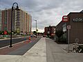
Corner of 66th St and Lyndale Avenue in downtown Richfield
-
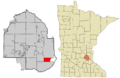
Location of Richfield
within Hennepin County, Minnesota
See also
 In Spanish: Richfield (Minnesota) para niños
