
Grand Rounds National Scenic Byway facts for kids
Quick facts for kids
[[File:|x70px|alt= marker]] Grand Rounds National Scenic Byway |
|
|---|---|
_-_NARA_-_68886456_(page_1).gif)
Route map of the Grand Rounds in Minneapolis
|
|
| Route information | |
| Length | 50 mi (80 km) |
| Existed | 1891–present |
| Location | |
| States: | Minnesota |
| Highway system | |
The Grand Rounds National Scenic Byway is a special loop of park areas in Minneapolis, Minnesota, USA. It's like a big circle that goes through the city, connecting many beautiful spots. The Minneapolis Park and Recreation Board created this system over many years. It has roads for cars and separate paths for people who want to walk or ride bikes. The byway is about 50 miles (80 km) long. Much of it was built in the 1930s by young people working in the Civilian Conservation Corps.
Contents
Exploring the Grand Rounds Districts
The Grand Rounds Byway is divided into seven main areas. Each district offers unique sights and activities:
- Downtown Riverfront is along the Mississippi River. Here you can see Saint Anthony Falls and old milling areas. The byway follows West River Parkway. It passes Boom Island Park, Nicollet Island Park, and Mill Ruins Park. This park is next to the Mill City Museum and the Stone Arch Bridge.
- Mississippi River Gorge stretches from downtown Minneapolis to Minnehaha Park. The byway follows West River Parkway. It goes past the west side of the University of Minnesota. You can find many ways to get to the Winchell Trail from here. Several bridges connect this byway section to trails on the east bank, in both Minneapolis and Saint Paul.
- Minnehaha includes Minnehaha Park, Minnehaha Creek, Lake Nokomis, and Lake Hiawatha. The byway follows Godfrey Parkway through Minnehaha Park. It passes Minnehaha Falls and the Longfellow House information center. After crossing Hiawatha Avenue, the route becomes Minnehaha Parkway. It goes between Lakes Nokomis and Hiawatha. Then it follows Minnehaha Creek to Lake Harriet.
- The Chain of Lakes has seven parks. This name has been used since the 1800s because the lakes look like a necklace. This district includes Lake Harriet, Lyndale Park, Lyndale Farmstead, Bde Maka Ska, Lake of the Isles, Cedar Lake, and Brownie Lake.
- Theodore Wirth extends into Golden Valley. It is made up of Theodore Wirth Park. The byway follows Cedar Lake Parkway, crosses Interstate 394, and becomes Theodore Wirth Parkway. Going north, it passes the Eloise Butler Wildflower Garden and Wirth Lake. After crossing Olson Memorial Highway, the parkway enters Theodore Wirth Golf Course.
- Victory Memorial covers the northwest part of Minneapolis. The byway follows Victory Memorial Parkway. This parkway honors people from Hennepin County who served in World War I. Victory Memorial Parkway then becomes Weber Parkway. The byway crosses the Mississippi River on the Camden Bridge.
- Northeast runs through Northeast Minneapolis. The byway follows St Anthony Parkway to Stinson Parkway. It then goes south on Stinson Parkway to Ridgway Parkway. It passes Columbia Park and Deming Heights Park. It ends at Francis Gross Golf Course.
Paths for Walking and Biking
The Grand Rounds has about 50 miles (80 km) of special paths. These paths are separate from the roads and form a continuous loop around Minneapolis. They are perfect for biking and walking.
Parkway Paths
- Memorial and Webber Parkways—3.85 miles (6.20 km)
- Wirth Parkway—3.54 miles (5.70 km)
- Dean Parkway—0.59 miles (0.95 km)
- William Berry Parkway—0.56 miles (0.90 km)
- Minnehaha Creek—4.93 miles (7.93 km)
- Godfrey Parkway—0.5 miles (0.80 km)
- West River and James I. Rice Parkways—7.25 miles (11.67 km)
- East River Parkway—about 2.1 miles (3.4 km)
- St. Anthony Parkway—2.8 miles (4.5 km)
- Stinson Parkway—0.95 miles (1.53 km)
- Ridgeway Parkway—0.75 miles (1.21 km)
Paths Around Lakes
- Lake Nokomis—2.7 miles (4.3 km)
- Lake Harriet—2.75 miles (4.43 km)
- Bde Mka Ska (used to be Lake Calhoun)—3.1 miles (5.0 km)
- Lake of the Isles—2.6 miles (4.2 km)
- Cedar Lake—1.68 miles (2.70 km)
How the Byway is Managed
The Grand Rounds was named a Minnesota State Scenic Byway in 1997. It became a National Scenic Byway in 1998. It is special because it's one of the best examples of an urban (city) byway. Most other scenic byways are in rural (countryside) areas. Parts of it are also part of the Great River Road along the Mississippi River.
Years ago, the city bought all the land right next to its lakes. This made sure that the lakes would be public parks. Because of this, everyone can visit and enjoy Minneapolis' beautiful lakes.
Large vehicles like semi-trailer trucks and buses are mostly not allowed on the byway. The speed limit is 25 miles per hour (about 40 km/h) everywhere. This low speed limit makes it a nice place for motorcycle riders. The roads often have a reddish color. This helps drivers see where to go at intersections.
Pictures of the Byway
-
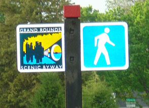
Sign and symbol designating the route
-
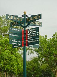
Directional street sign
-
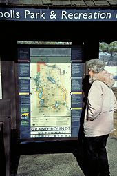
Informational kiosk
-
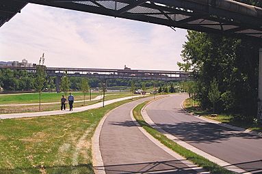
East River Flats' separate roadway and paths


