Brownie Lake facts for kids
Quick facts for kids Brownie Lake |
|
|---|---|

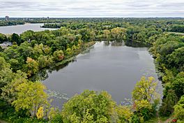
The view looking south over Brownie Lake, with Cedar Lake in the background in October 2019
|
|
| Location | Minneapolis, Minnesota, US |
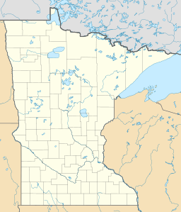
| Coordinates | 44°58′03″N 93°19′28″W / 44.96750°N 93.32444°W |
| Managing agency | Minneapolis Park and Recreation Board |
| Surface area | 18 acres (0.073 km2) |
| Average depth | 20.3 feet (6.2 m) |
| Max. depth | 49.9 feet (15.2 m) |
Brownie Lake is a beautiful lake located in Minneapolis, Minnesota. It's the northernmost lake in the famous Minneapolis Chain of Lakes. This chain includes Brownie Lake, Cedar Lake, Lake of the Isles, Bde Maka Ska, and Lake Harriet. Brownie Lake is part of Brownie Lake Park and is managed by the Minneapolis Park and Recreation Board.
Contents
What Makes Brownie Lake Special?
A Lake That Doesn't Mix
Brownie Lake is a special type of lake called a meromictic lake. This means it has two layers of water that don't mix, even during spring and fall. Most lakes in cooler climates mix completely twice a year. In Brownie Lake, a boundary called a chemocline separates the top layer (which has oxygen) from the bottom layer (which doesn't have oxygen). Brownie Lake is one of only two such lakes in Minneapolis.
Water Flow and What's in It
Brownie Lake doesn't have natural streams flowing into it. Instead, it gets water from storm drains around the lake. Water flows out of Brownie Lake through a canal that connects it to Cedar Lake. Cedar Lake then connects to Lake of the Isles and Bde Maka Ska. Brownie Lake is also part of the Minnehaha Creek Watershed District, which helps manage water in the area.
For a long time, Brownie Lake had high levels of dissolved iron, especially in its deeper parts. This was partly due to an industrial cooling system that used to discharge water into the lake from the 1950s to the 1990s.
The lake also has high levels of phosphate. Some of this phosphate comes from human activities. In the past, water was even pumped into Brownie Lake from Bassett Creek and the Mississippi River to keep water levels up in the Chain of Lakes. However, this program was stopped in the 1990s because of concerns about pollution.
Road Salt and Lake Layers
Over the years, the amount of salt (sodium and chloride) in Brownie Lake has increased. This is mainly because of road salt used to de-ice nearby roads, like Interstate 394. Road salt can make the lake's layers even more stable, preventing them from mixing. This means the lake stays meromictic, with its distinct top and bottom layers.
How Brownie Lake Was Formed
Glaciers and Ancient Valleys
The land around Brownie Lake was shaped by ancient glaciers. These huge ice sheets, from about 16,500 to 13,900 years ago, left behind layers of sand, gravel, and dirt. Some of these materials came from the iron-rich Lake Superior region.
Brownie Lake sits on the edge of a "buried bedrock valley." Imagine old river valleys that were later filled in with tons of glacial debris. These buried valleys aren't easy to see on the surface, but they often have clusters of lakes, like Brownie Lake, and can influence where modern rivers flow. You can even find out more about the geology of the Chain of Lakes by following a special bicycle guide!
Plants and Animals in Brownie Lake
Lake Life
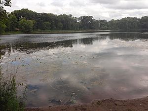
In the open water of Brownie Lake, you can find plants like yellow and white water lilies, coontail, and pondweeds. Unfortunately, some invasive species, like Eurasian watermilfoil and curly-leaf pondweed, are also present. The areas around the lake have forests, woodlands, and prairies.
Fish and Tiny Creatures
The Minnesota Department of Natural Resources has found many types of fish in Brownie Lake. These include black bullhead, black crappie, bluegill, largemouth bass, northern pike, walleye, and yellow perch.
Tiny living things called phytoplankton (like tiny plants) are more common than zooplankton (tiny animals) in Brownie Lake. Different types of these tiny creatures appear at different times of the year. For example, cyanobacteria (often called blue-green algae) are common in the summer.
In the deep, oxygen-free parts of the lake, there are special tiny organisms called methanogenic archaea that produce methane gas. Near the boundary between the layers, there are bacteria called methanotrophs that eat this methane.
History of Brownie Lake
How the Lake Got Its Name
The land around Brownie Lake was bought in 1857 by William McNair. He named the lake "Brownie" after his daughter, Agnes McNair, who had that nickname. It used to be called "Hillside Harbor." Later, in 1907, Brownie Lake became part of Glenwood Park, which is now Theodore Wirth Park.
Changes to the Lake's Size
In 1867, a railroad track was built across the southern end of Brownie Lake. Then, in 1883, the track was expanded into a double track. This expansion filled in a part of the lake, reducing its size by 34%.
The lake's surface area got even smaller between 1913 and 1917. Channels were built to connect Cedar Lake and Lake of the Isles (1913), and then Cedar Lake and Brownie Lake (1916). These connections lowered Brownie Lake's water level by 2 to 3 meters. This made the lake much smaller and more sheltered from the wind.
It's believed that Brownie Lake became meromictic (the layers stopped mixing) because of this big drop in water level. With less wind mixing the water, oxygen couldn't reach the bottom. This allowed iron and other substances to build up in the deep water, making it denser. This density difference made it even harder for the wind to mix the lake, creating a cycle that kept the layers separate. This special mixing pattern likely started by 1925.
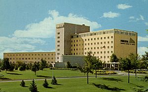
The land west of Brownie Lake, which was once part of Theodore Wirth Park, was sold in 1952 to the Prudential Insurance Company. Later, in 1994, it was sold to Target Corporation. Target moved its employees from this site in 2015 and put the property up for sale.
Fun Things to Do at Brownie Lake
Trails and Paths
Brownie Lake is surrounded by a dirt walking path, perfect for a stroll. There's also a paved path nearby, the Cedar Lake Trail, which is part of the Grand Rounds National Scenic Byway. This path is great for walking, running, or biking.
If you like mountain biking, Brownie Lake Park has a 1.4-mile single-track trail along the western side of the lake. This trail connects to other biking loops and is maintained by Minnesota Off-Road Cyclists. It was the first "Black Diamond" trail in Minneapolis, built in 2016, meaning it's quite challenging!
Boating and Winter Fun
You can't use motor boats on Brownie Lake, but it's a great spot for canoeing or kayaking. There's a special rack near the boat ramp where you can rent space for your canoe or kayak from the Minneapolis Park and Recreation Board.
In the winter, the Chain of Lakes Ski Trail extends across Brownie Lake and connects to the Theodore Wirth Park trails. These trails are maintained by the Minneapolis Park and Recreation Board and the Loppet Foundation, and you can get passes from the Loppet Foundation to enjoy winter sports.
 | Claudette Colvin |
 | Myrlie Evers-Williams |
 | Alberta Odell Jones |


