
Cedar Lake Trail facts for kids
Quick facts for kids Cedar Lake Trail |
|
|---|---|

Cedar Lake Trail west of downtown with a directional sign.
|
|
| Cedar Lake Trail | |
| Length | 4.3 mi (6.9 km) |
| Location | Minneapolis, Minnesota, United States |
| Use | Cycling, Pedestrians |
| Elevation | |
| Grade | Mostly flat |
| Cycling details | |
| Trail difficulty | Easy |
| Season | Year-round |
| Sights | City skyline views |
| Hazards | Detours due to construction |
| Surface | Pavement |
The Cedar Lake Trail is a popular path in Minnesota. It is about 4.3-mile (6.9 km) long. This trail connects downtown Minneapolis to the nearby city of St. Louis Park.
It is a shared path for both bikes and people walking. The trail starts in downtown Minneapolis. It then goes west towards Minnesota State Highway 100 in St. Louis Park. From there, another paved path continues for about 4.2 miles (6.8 km). This part goes through St. Louis Park to Hopkins. It is now called the North Cedar Lake Regional Trail.
In recent years, parts of the Cedar Lake Trail have been closed. This is due to construction for the Southwest LRT train line. The trail is expected to fully reopen soon.
Contents
What is the Cedar Lake Trail?
The Cedar Lake Trail was the first bike trail in the country to get money from the government. It is sometimes called a "bicycle freeway." This is because it has three lanes in most parts of Minneapolis. There are separate one-way lanes for bikes. There is also a third lane for people walking in both directions.
The trail is also a rail trail. This means it follows an old railroad line. This line used to belong to the BNSF Railway. The North Cedar Lake Trail continues to follow this line.
Connecting Trails
The Cedar Lake Trail connects to many other trails in Minneapolis. This makes it easy to explore the city.
- A bridge over the BNSF tracks links to Bryn Mawr Park. It also connects to a part of the Luce Line Regional Trail.
- A short path leads to Parade Stadium. This path connects to Kenwood Parkway.
- The Kenilworth Trail is a longer path. It follows an old railway line along Cedar Lake. This trail connects to the Midtown Greenway and the Southwest LRT Trail. It also links to the Grand Rounds National Scenic Byway trail system around Bde Maka Ska.
- Another path follows the west side of Cedar Lake. This path is also part of the Grand Rounds trail system.
The North Cedar Lake Trail also connects to other trails in St. Louis Park. At its western end, it meets the Southwest LRT Trail. This is near U.S. Highway 169 in Hopkins. The Cedar Lake Regional Trail and its connected paths form a big loop. This loop is about 12.5 miles long.
History of the Trail
The Cedar Lake Trail is built on land that used to be railroad yards. These yards belonged to the Great Northern Railway and the Minneapolis and St. Louis Railway.
From Railroad to Park
In the late 1980s, the railroad companies moved their facilities. The land became available for public use. In 1989, a group called the Cedar Lake Park Association started a big effort. They gathered thousands of people to help. They also raised over $500,000. Their goal was to buy the land from the railroad. They wanted to create Cedar Lake Park.
Then, in 1995, the association worked with the Minneapolis Park and Recreation Board. They also worked with Minneapolis Public Works. Together, they led the effort to create the Cedar Lake Regional Trail. The association members gave another $500,000 for the trail. The rest of the money came from federal and state governments. The total cost was $1.6 million. This money paid for the first two parts of the trail. These parts were built in 1995. They stretched from Highway 100 in the west to Royalston Avenue near downtown Minneapolis.
Trail Extensions
The third part of the Cedar Lake Regional Trail started being built in 2010. This part extended the trail about 1 mile (1.6 km) further east. It goes under Target Field and past the Target Field train station. It finally reaches West River Parkway along the Mississippi River. This final section officially opened on June 14, 2011.
The new Southwest Corridor light rail line will run next to the Cedar Lake Trail. This train line will go from Royalston Avenue southwest past Interstate 394. This is a distance of about 1.5 miles (2.4 km). The light rail line will then turn southwest.
The final part of the trail cost $9.2 million. It was a complex project. It took over 11 years to plan and build. This was because of changes in plans. For example, the new Twins baseball stadium, Target Field, was built over the space for the trail. The BNSF railroad had to move its tracks to make room for both the trail and the stadium.
Throughout this long process, the Cedar Lake Park Association played a key role. They are a group of volunteers. They helped make sure the project got finished. As the mayor said, "Citizens groups like the Cedar Lake Park Association hold [public official's] feet to the fire to make sure projects like this get done."
Images for kids
-
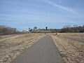
A look at the Cedar Lake Trail heading into downtown Minneapolis, from early spring of 2006.
-
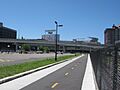
An extension of the Cedar Lake Trail connecting to Target Field and the Mississippi


