
Winchell Trail facts for kids
Quick facts for kids Winchell Trail |
|
|---|---|

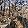
In early March, a limestone staircase descends from a scenic overlook to Winchell Trail.
|
|
| Length | 5 mi (8.0 km) |
| Location | Minneapolis, Minnesota, United States |
| Trailheads |
|
| Use |
|
| Elevation change | 501 feet (153 m) |
| Difficulty | Moderate |
| Season | Year round |
| Sights |
|
| Hazards | Natural surface portions may be muddy after storms or snow melt |
The Winchell Trail is a cool hiking path in Minneapolis, Minnesota. It's about 5 miles (8 km) long, going along the west side of the Mississippi River. This trail is just for people walking, not bikes. It runs between Franklin Avenue South and East 44th Street.
Many people who love birds and nature enjoy this trail. It gives you amazing views of the Upper Mississippi River gorge. The Winchell Trail is separate from the bike path next to it. As you hike, you'll see sandy beaches, a special oak savanna area, and a forest that floods sometimes.
You can get onto the trail from many spots. Part of the trail, from East 38th Street to East 44th Street, is paved. The Winchell Trail is considered "moderate" difficulty, good for all skill levels. It goes out and back, with a total climb of about 501 feet (153 meters). Some parts of the trail are very quiet, making it a great place to explore.
Contents
Exploring the Trail

The Winchell Trail has many places where you can start your adventure. These spots are usually found along the West River Parkway trail, which is part of the Grand Rounds National Scenic Byway.
Where to Start Your Hike
The main starting point in the north is near Franklin Avenue South and West River Parkway. The southern starting point is close to East 44th Street and West River Parkway. There's also a clear entrance at East 36th Street. From there, several paths lead down to the special oak savanna area.
You can find a few small parking lots along the trail route. Two are near East 36th Street, and one is near East 44th Street. Many access points have bike racks. Remember, bikes are not allowed on the Winchell Trail or other dirt paths in the gorge.
Cool Places to See
Here are some interesting spots you'll find along the trail, going from north to south:
- The northern starting point has a big rock called the Mesabi Iron Range boulder.
- Hajduk Spring is a natural spring near East 26th Street.
- White Sands Beach is a sandy spot near East 28th Street.
- Longfellow Beach is another beach area near East 33rd Street.
- You'll find a great view of the river gorge at East 36th Street.
- The oak savanna restoration project is also near East 36th Street.
- The southern starting point near East 44th Street also has a nice view of the river gorge.
The Big Boulder
At the northern end of the trail, there's a huge boulder. It has a bronze plaque (a special metal sign) that talks about Newton Horace Winchell. The trail is named after him. This giant rock was brought from the Mesabi Iron Range by Winchell's oldest son. The sign on it explains how Winchell studied the area and helped people understand Minnesota's natural resources.
Hajduk Spring
Hajduk Spring is a natural spring in Minneapolis. Water flows down from a limestone cliff above the Mississippi River near East 26th Street. It's named after Harry Hajduk, a local person who cared a lot about the spring. For a long time, people used to drink water from this spring. There was even a platform to fill up jugs.
However, the old path to the spring is now ruined. Also, experts say the water from the spring is not safe to drink anymore. This is because of chemicals like herbicides and fertilizers used on lawns nearby.
The Oak Savanna Project

Near East 36th Street, you'll find a special area called the mesic oak savanna. It's a unique and delicate landscape. Here, the Winchell Trail splits. You can either go down by the river or take another path that crosses this hilly area. This spot is being restored to look like it did before European settlers arrived.
In an oak savanna, oak trees are spread out. They don't form a thick roof of leaves. This allows sunlight to reach the ground, letting prairie grasses, wildflowers, and clover grow. The Minneapolis Park and Recreation Board is working to improve this area. They might close paths that aren't good for the environment and add new signs to teach visitors about the savanna.
Other Nearby Trails
The southern end of the Winchell Trail connects easily to a shared path for bikes and walkers. This is at West River Parkway and East 44th Street. From there, hikers can keep going south. You can reach places like Lock and Dam No. 1, the Minnehaha Falls Lower Glen Trail in Minnehaha Park, and Fort Snelling State Park. These are all connected by the Minnehaha Trail.
History of the Trail

First People of the Land
The Dakota people have lived along the shores of the Upper Mississippi River for many, many centuries. The path that is now the Winchell Trail might have been an original trail created by the Dakota people long ago. When you hike the trail today, you can imagine what a native oak savanna looked like before European-Americans settled here.
How the Trail Was Built
The Winchell Trail was planned by Minneapolis Parks Superintendent Theodore Wirth. It was built between 1912 and 1914. Later, between 1936 and 1938, the Works Progress Administration (WPA) improved the trail. They added stone walls and staircases.
The trail is named after Newton Horace Winchell. He was a state geologist for Minnesota. In the 1870s, he studied the Minneapolis area. He wrote many books about how long ago the ice age ended. The path was officially named "Winchell Trail" after he passed away in 1914. Newton Horace Winchell was not involved in designing or building the trail himself.
Who Takes Care of It
Many groups help manage the Winchell Trail. It's located along the eastern edge of the Longfellow community in Minneapolis. The trail is part of the Mississippi National River and Recreation Area and Mississippi Gorge Regional Park. The Minneapolis Park and Recreation Board is in charge of keeping it managed and maintained.
In 1998, the Longfellow neighborhood, the park board, and the National Park Service worked together. They formed a team to restore the native prairie and oak savanna at East 36th Street. Since the early 2000s, the city has also been trying to remove unwanted plants, like buckthorn, from the bluff area.
Why It's Special
The Winchell Trail has been recognized as a great place to hike. In 2010, a local TV station called it one of the top five hiking trails in the Twin Cities. In 2018, a local magazine featured the Winchell Trail in its review of the best hikes in Minnesota. They even put it in the category for "Rigorous Hikes for the Adventurer."
The Trail's Future
In 2019, the park board was thinking about ways to make the Winchell Trail even better. They were looking at fixing railings and fences that are worn out. They also wanted to improve paved sections that are covered in dirt and plants. Another goal was to make the natural dirt paths clearer and safer. There are other unofficial dirt paths in the area, but these were made by people walking, not by planners, so they aren't considered good for the environment in the long run.
Images for kids
-
In early March, a limestone staircase descends from a scenic overlook to Winchell Trail.
