Minnehaha Falls Lower Glen Trail facts for kids
Quick facts for kids Minnehaha Falls Lower Glen Trail |
|
|---|---|

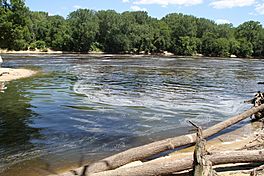
In summer, the confluence of Minnehaha Creek and the Mississippi River at a sandy beach.
|
|
| Length | 2.1 mi (3.4 km) |
| Location | Minneapolis, Minnesota, United States |
| Trailheads |
|
| Use | Hiking only |
| Difficulty | Easy |
| Season | Year round |
| Sights |
|
| Hazards |
|
The Minnehaha Falls Lower Glen Trail is a well-loved hiking path in Minneapolis, Minnesota, USA. This trail is about 2.1 miles (or 3.4 kilometers) long. It starts and finishes at the bottom of the famous Minnehaha Falls. Hikers walk on natural paths and raised wooden walkways. These paths go through a valley carved by Minnehaha Creek. The creek flows into the Mississippi River at a sandy beach. Some parts of the trail can be a bit challenging.
Contents
Exploring the Minnehaha Falls Trail
The Minnehaha lower glen is a canyon area. It stretches from Minnehaha Falls down to where Minnehaha Creek meets the Mississippi River. You can get to the hiking trail loop by taking stairs near Minnehaha Falls. These stairs lead down to the valley floor.
How to Access the Trail
Once you go down the stairs, you will find dirt paths. These paths follow both sides of the creek. The ground slowly changes height as you walk towards the Mississippi River. The area where the creek meets the river is the lowest point in Minneapolis. It is about 686 feet (209 meters) above sea level.
For safety, the park closes the staircases in winter. But don't worry! You can still get to the trail all year round. Just use the Glens Area by Godfrey Parkway or the South Plateau Area near a dog park.
Trail Difficulty and Features
The trail on the north side of the creek is mostly considered "moderate." This means it's not too hard, but not super easy either. The trail on the south side is a bit more challenging. Some parts of the trail have boardwalks. These are wooden walkways built over ponds and muddy areas.
There are five pedestrian bridges in the park. Bridges 2 through 5 are in the lower glen. These bridges let hikers cross the creek easily.
What You Might See on Your Hike
As you hike, you can spot many interesting things:
- An old, grassy area where a waterfall used to be.
- A black ash swamp.
- The ruins of the old Godfrey Mill.
- Historic stone bridges and walls.
- A natural wading pool area.
- Tall bluffs made of Platteville Limestone.
- A sandy beach where the creek meets the river.
- Lots of different wildlife!
History of the Minnehaha Trail
This hiking trail is completely inside Minnehaha Regional Park. The Minneapolis Park and Recreation Board takes care of this park. The lower glen area, which is about 54 acres, used to be a bit neglected.
Restoration Efforts and Improvements
Around 2010, the Minnehaha Creek Watershed District spent about $7 million to improve the area. They worked on many things, like:
- Making the trails better.
- Making the creek banks stronger.
- Removing plants that didn't belong there.
- Replacing old boardwalks.
- Rebuilding stone walls and bridges.
In 2014, there was a very heavy rainstorm. This storm caused problems for the improvements made to the glen. The new designs were not made to handle so much rain.
 | Janet Taylor Pickett |
 | Synthia Saint James |
 | Howardena Pindell |
 | Faith Ringgold |

