Minnehaha Trail facts for kids
Quick facts for kids Minnehaha Trail |
|
|---|---|

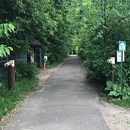
The north entrance of Minnehaha Trail from Minnehaha Regional Park.
|
|
| Length | 1.5 mi (2.4 km) |
| Location | Minneapolis, Minnesota, United States |
| Designation |
|
| Trailheads | |
| Use |
|
| Elevation change | 272 feet (83 m) |
| Difficulty | Easy |
| Season | Year round |
| Sights |
|
| Hazards | Poor trail maintenance |
The Minnehaha Trail is a fun, paved path in Minneapolis, Minnesota. It's about 1.5 miles (2.4 km) long. This trail connects two popular spots: Minnehaha Regional Park and Fort Snelling State Park. These parks are big attractions in the Twin Cities area.
The Minnehaha Trail is part of a bigger bike route system along the amazing Mississippi River. As you travel, you'll ride under a cool forest canopy. People love this trail for its natural beauty. However, some parts of the path need repairs, and there aren't many signs to guide you.
Contents
Exploring the Minnehaha Trail
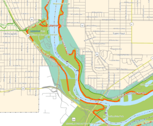
The Minnehaha Trail is 1.5 miles (2.4 km) long one way. If you go there and back, it's 3 miles (4.8 km). This trail connects Minnehaha Regional Park and Fort Snelling State Park. Even though many people visit these parks, the Minnehaha Trail itself isn't usually crowded.
The trail starts at its southern end in Fort Snelling State Park. This is near the Thomas C. Savage Visitor Center. From there, it's a gentle climb of about 272 feet (83 meters). You'll walk or bike through a thick forest. Sometimes, you'll get cool views of the Mississippi River gorge.
When you reach Minnehaha Regional Park, you'll be near a dog park. From here, you can connect to other trails in the park. You can also join the bigger Grand Rounds trail system. If you start at the southern end, you can also easily connect to the Snelling Lake Trail.
Other Trails Nearby

It can be a bit tricky to find the Minnehaha Trail. This is because there are many paths in the area. Also, some online maps might have mistakes, and there aren't many signs. For example, some maps might wrongly call it the "Minnesota Valley State Trail." That trail doesn't actually go all the way to Fort Snelling State Park.
There's another bike trail close to Highway 55. This path lets you go under the highway. It also leads to parking lots in the upper part of Fort Snelling State Park. Some maps call this the "Fort Snelling State Trail." Others call it the "Hiawatha MDOT Trail." It's easy to mix this one up with the Minnehaha Trail.
Near the old fort, there's a steep trail that connects the upper and lower parts of Fort Snelling State Park. This path lets you reach many different trails. From the upper part of the park, near a chapel, you can get to the Big Rivers Regional Trail.
Part of a Big Bike Network
The Minnehaha Trail is part of the Mississippi River Trail, also called the MRT. This is a huge bike route that links together over 800 miles (1,287 km) of roads and trails in Minnesota. It's also known as U.S. Bicycle Route 45. You might see a few old "MRT" signs on the Minnehaha Trail. However, the area is known for not having enough signs.
What People Think About the Trail
In 2012, a local newspaper called City Pages said the Minnehaha Trail was the best bike route in the region. They wrote that the Twin Cities has many great bike trails. But for them, the Minnehaha Trail was the most beautiful. They loved how it runs under a thick canopy of trees. They also liked that it goes beneath the bluffs overlooking the Mississippi River. It felt like a real escape from the city.
However, by 2016, people said the Minnehaha Trail really needed to be fixed. Some parts were so bumpy that it was hard to ride a bike on them.
 | Chris Smalls |
 | Fred Hampton |
 | Ralph Abernathy |

