Minnesota Valley State Trail facts for kids
Quick facts for kids Minnesota Valley State Trail |
|
|---|---|

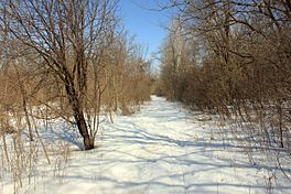
The mixed-use path in winter.
|
|
| Length | 27 mi (43 km) |
| Location | Minnesota, United States |
| Trailheads |
|
| Use | Mixed-use path |
| Season | Year-round |
| Sights | Minnesota River Valley |
| Hazards | Muddy; flooding |
The Minnesota Valley State Trail is a cool outdoor path in the Minneapolis-Saint Paul area. It's about 27 miles (43 km) long. This trail follows the Minnesota River from Belle Plaine to Shakopee.
You can use this trail for many activities. People enjoy hiking, biking, horseback riding, cross-country skiing, and even snowmobiling here. Part of the trail, about 10 miles (16 km) from Chaska to Shakopee, is paved. The trail first started in 1969. It's getting even longer with a 13.5-mile (22 km) extension being built in 2019 and 2020.
Contents
Exploring the Trail
The Minnesota Valley State Trail winds through different natural areas. You'll see forests, open areas, wetlands, and lakes. Many parts of the trail go through dense oak forests and oak savannas.
What You'll See
When you're on the trail, especially near the Minnesota Valley State Recreation Area, you might notice floodplains. These are flat areas next to the river that can get flooded when the water level rises. Because of this, some low-lying parts of the trail can get muddy or flood sometimes.
Trail's Elevation
Even though the trail is long, it's mostly flat. The highest point is about 800 feet (242 m) above sea level. The lowest point is around 713 feet (218 m). This makes it a pretty easy path for most activities.
What is a State Corridor Trail?
Sometimes, people call this trail the "State Corridor Trail." In Minnesota, a state corridor trail is a big network of trails. These trails connect different areas and are often very long. The Minnesota Department of Natural Resources helps manage some of these trails. Other parts might be managed by local towns. The Minnesota Valley State Trail is one example of this type of connected trail system.
History of the Trail
The Minnesota River valley is a very important natural area. It's especially key where it meets the Mississippi River near Fort Snelling State Park.
How the Trail Started
In 1969, the Minnesota Legislature decided to create a state trail system. This system was planned for the Minnesota River valley, stretching from Le Sueur to Fort Snelling State Park. However, only the 27-mile (43 km) section from Belle Plaine to Shakopee was built by 2019. This section includes a 17-mile (27 km) natural surface trail and a 10-mile (16 km) paved trail.
Who Manages the Trail?
The Minnesota Department of Natural Resources (DNR) takes care of the trail. Even though the DNR manages it, parts of the trail also go through areas managed by state, local, and even federal groups. The DNR hopes to make the trail even longer in the future if they get more resources.
New Trail Sections
In 2019, the DNR started building a new part of the trail. This new section goes through the city of Bloomington. This 13.5-mile (22 km) extension will connect the trail from the Bloomington Ferry Bridge to the Minnesota Valley National Wildlife Refuge Visitor Center. This visitor center is inside the Mississippi National River and Recreation Area.
Once this new part is finished, you'll be able to connect to the Big Rivers Regional Trail from the wildlife refuge. Some parts of this new extension will be paved. This caused some discussion, especially among mountain biking fans, who sometimes prefer unpaved trails.
 | Delilah Pierce |
 | Gordon Parks |
 | Augusta Savage |
 | Charles Ethan Porter |

