Ramsey County, Minnesota facts for kids
Quick facts for kids
Ramsey County
|
|
|---|---|

|
|

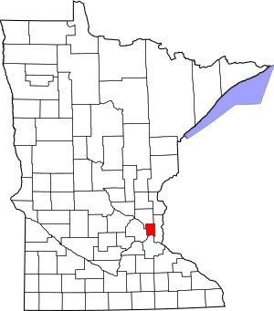
Location within the U.S. state of Minnesota
|
|
 Minnesota's location within the U.S. |
|
| Country | |
| State | |
| Founded | October 27, 1849 |
| Named for | Alexander Ramsey |
| Seat | Saint Paul |
| Largest city | Saint Paul |
| Area | |
| • Total | 170 sq mi (400 km2) |
| • Land | 152 sq mi (390 km2) |
| • Water | 18 sq mi (50 km2) 11%% |
| Population
(2020)
|
|
| • Total | 552,352 |
| • Estimate
(2023)
|
536,075 |
| • Density | 3,633.9/sq mi (1,403.1/km2) |
| Time zone | UTC−6 (Central) |
| • Summer (DST) | UTC−5 (CDT) |
| Congressional districts | 4th, 5th |
Ramsey County is a county in Minnesota, a state in the United States. In 2020, about 552,352 people lived here. This makes it the second most populated county in Minnesota.
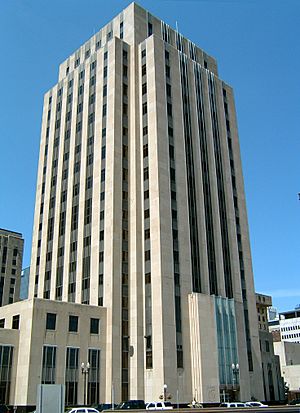
The main city and county seat is Saint Paul. Saint Paul is also the capital city of Minnesota. It is a "twin city" with Minneapolis.
Ramsey County was started in 1849. It is named after Alexander Ramsey. He was the very first governor of the Minnesota Territory.
This county is part of the larger Minneapolis–Saint Paul Metropolitan Area. It is the smallest county in Minnesota by land size. It is also the most densely populated. This means many people live close together here.
Contents
History of Ramsey County
When the Minnesota Territory was created in 1849, nine counties were formed. Ramsey County was one of them. Back then, Ramsey County was much bigger. It included areas that are now other counties like Anoka and Isanti.
One of the first people to settle here was Heman Gibbs. His old farm is now a museum. It is called the Gibbs Museum of Pioneer and Dakotah Life in Falcon Heights. For a long time, Ramsey County was mostly farmland. Then, small towns started to grow. North St. Paul became a town in 1887. New Brighton followed in 1891. And White Bear Lake became a town in 1921.
Geography and Nature
Ramsey County covers about 170 square miles. About 152 square miles are land. The other 18 square miles (11%) are water. It is the smallest county in Minnesota. Since 1990, it has been considered a fully urban area. This means it is mostly cities and towns.
Neighboring Counties
Ramsey County shares borders with these counties:
- Anoka County (north)
- Washington County (east)
- Dakota County (south)
- Hennepin County (west)
Protected Natural Areas
Part of the Mississippi National River and Recreation Area is in Ramsey County. This area helps protect the Mississippi River.
Getting Around Ramsey County
You can travel through Ramsey County by train, car, or even plane.
Train Travel
Ramsey County is a busy place for freight trains. Major railway companies like BNSF, Union Pacific, and Canadian Pacific use it.
For people, Amtrak offers daily passenger train service. You can catch the Empire Builder train from Union Depot in Saint Paul.
There is also a light rail system called Metro. It connects different communities in Ramsey and Hennepin Counties. The Metro Green Line links Saint Paul Union Depot to Minneapolis.
Roads and Highways
Many major highways run through Ramsey County. These include Interstate 35 and Interstate 94.
- I-35E goes through Saint Paul. It connects with I-94 there.
- I-35W crosses from Minneapolis. It goes through New Brighton.
- I-94 enters from Minneapolis. It runs near University Avenue in Saint Paul.
- I-694 goes through New Brighton and Little Canada.
Several U.S. Highways also serve the county. These include US 10, US 52, and US 61. Many Minnesota State Highways are also important for travel.
The county also manages many local roads and bridges. The Public Works Department keeps them in good shape.
Main Roads
 Interstate 35E
 Interstate 35W
 Interstate 94
 Interstate 694
 U.S. Highway 10
 U.S. Highway 12
 U.S. Highway 52
 U.S. Highway 61
 Minnesota State Highway 5
 Minnesota State Highway 13
 Minnesota State Highway 36
 Minnesota State Highway 51
 Minnesota State Highway 96
 Minnesota State Highway 120
 Minnesota State Highway 149
 Minnesota State Highway 156
 Minnesota State Highway 280
 County Road 30 (Larpenteur Avenue)
 County Road 34 (University Avenue)
 County Road 36/37 (Shepard Road/Warner Road)
- Other county roads
Airports
The main airport for Ramsey County is Minneapolis–Saint Paul International Airport. It is in Hennepin County, which is next door.
Ramsey County has one airport within its borders. It is called Saint Paul Downtown Airport. This airport is smaller. It is mostly used for private planes and military flights.
People of Ramsey County
| Historical population | |||
|---|---|---|---|
| Census | Pop. | %± | |
| 1850 | 2,227 | — | |
| 1860 | 12,150 | 445.6% | |
| 1870 | 23,085 | 90.0% | |
| 1880 | 45,890 | 98.8% | |
| 1890 | 139,796 | 204.6% | |
| 1900 | 170,554 | 22.0% | |
| 1910 | 223,675 | 31.1% | |
| 1920 | 244,554 | 9.3% | |
| 1930 | 286,721 | 17.2% | |
| 1940 | 309,935 | 8.1% | |
| 1950 | 355,332 | 14.6% | |
| 1960 | 422,525 | 18.9% | |
| 1970 | 476,255 | 12.7% | |
| 1980 | 459,784 | −3.5% | |
| 1990 | 485,765 | 5.7% | |
| 2000 | 511,035 | 5.2% | |
| 2010 | 508,640 | −0.5% | |
| 2020 | 552,352 | 8.6% | |
| 2023 (est.) | 536,075 | 5.4% | |
| U.S. Decennial Census 1790-1960 1900-1990 1990-2000 2010-2020 |
|||
Population in 2020
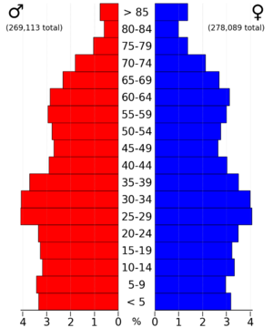
In 2020, the county had 552,352 people. The population is made up of many different groups.
| Race / Ethnicity | Pop 2010 | Pop 2020 | % 2010 | % 2020 |
|---|---|---|---|---|
| White alone (NH) | 340,194 | 320,477 | 66.89% | 58.02% |
| Black or African American alone (NH) | 54,835 | 70,101 | 10.78% | 12.69% |
| Native American or Alaska Native alone (NH) | 3,143 | 2,914 | 0.62% | 0.53% |
| Asian alone (NH) | 59,033 | 85,775 | 11.61% | 15.53% |
| Pacific Islander alone (NH) | 195 | 214 | 0.04% | 0.04% |
| Some Other Race alone (NH) | 737 | 2,339 | 0.15% | 0.42% |
| Mixed Race/Multi-Racial (NH) | 14,020 | 25,498 | 2.76% | 4.62% |
| Hispanic or Latino (any race) | 36,483 | 45,034 | 7.17% | 8.15% |
| Total | 508,640 | 552,352 | 100.00% | 100.00% |
Note: The US Census counts Hispanic/Latino people as an ethnic group. This chart separates them from the racial groups. Hispanic/Latino people can be of any race.
Population in 2010
In 2010, there were 508,640 people living in Ramsey County. About 70.1% were White. 11.0% were Black or African American. 11.7% were Asian. About 7.2% of the people were Hispanic or Latino.
Many people in Ramsey County have German roots (26.0%). Other large groups have Irish (11.5%), Norwegian (9.9%), and Swedish (7.4%) backgrounds.
Cities and Towns
Ramsey County has many cities and one township.
Cities
- Arden Hills
- Blaine (partly)
- Falcon Heights
- Gem Lake
- Lauderdale
- Little Canada
- Maplewood
- Mounds View
- New Brighton
- North Oaks
- North Saint Paul
- Roseville
- Saint Paul (the main city)
- Shoreview
- Spring Lake Park (partly)
- Saint Anthony (partly)
- Vadnais Heights
- White Bear Lake (partly)
Townships
Unincorporated Communities
These are areas that are not part of a city or township.
Education in Ramsey County
Many school districts serve the children of Ramsey County.
- Mounds View Public School District
- North St. Paul-Maplewood-Oakdale School District
- Roseville Public School District
- St. Anthony-New Brighton Schools
- St. Paul Public School District
- White Bear Lake School District
There are also charter schools. These are public schools that have more freedom in how they operate.
- Hmong College Prep Academy
- Metro Deaf School
See also
 In Spanish: Condado de Ramsey (Minnesota) para niños
 | Selma Burke |
 | Pauline Powell Burns |
 | Frederick J. Brown |
 | Robert Blackburn |


