Little Canada, Minnesota facts for kids
Quick facts for kids
Little Canada
|
||
|---|---|---|
|
City
|
||
|
||

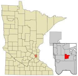
Location of the city of Little Canada
within Ramsey County, Minnesota |
||
| Country | ||
| State | Minnesota | |
| County | Ramsey | |
| Founded | 1858 | |
| Incorporated (village) | 1953 | |
| Incorporated (city) | 1974 | |
| Government | ||
| • Type | Minnesota Statutory City | |
| Area | ||
| • Total | 4.49 sq mi (11.62 km2) | |
| • Land | 3.90 sq mi (10.10 km2) | |
| • Water | 0.59 sq mi (1.52 km2) | |
| Elevation | 906 ft (276 m) | |
| Population
(2020)
|
||
| • Total | 10,819 | |
| • Estimate
(2021)
|
10,499 | |
| • Density | 2,775.53/sq mi (1,071.56/km2) | |
| Time zone | UTC-6 (CST) | |
| • Summer (DST) | UTC-5 (CDT) | |
| ZIP codes |
55109, 55117
|
|
| Area code(s) | 651 | |
| FIPS code | 27-37502 | |
| GNIS feature ID | 2395733 | |
Little Canada is a city in Ramsey County, Minnesota, United States. It's a suburb located near the larger cities of Minneapolis-Saint Paul. In 2020, the city had a population of 10,819 people.
Contents
History of Little Canada
Little Canada has a rich history that dates back to the mid-1800s. It started as a small settlement and grew into the city it is today.
Early Settlers and Mills
In 1844, a French Canadian settler named Benjamin Gervais moved north from Saint Paul. He wanted to claim land to build the first grist mill in Minnesota that wasn't controlled by the government. A grist mill is a place where grain is ground into flour.
The large lake on the east side of Little Canada is named Lake Gervais after him. This grist mill area was later turned into a park. It is known as the birthplace of the city.
Becoming a City
Little Canada began as the township of New Canada in 1858. A township is a type of local government area.
In the 1950s, the area faced a challenge. Bigger communities like Maplewood were growing fast, and their suburban areas were spreading. To protect their community, leaders in New Canada decided to form a village. In 1953, they officially established the village of Little Canada. It later became a full city in 1974.
Canadian Connections
The city of Little Canada shows its Canadian roots in many ways. Its official symbol features the letters "LC" on a white fleur-de-lis. This is a traditional French symbol. The background of the symbol is a red maple leaf, which is a well-known symbol of Canada. The Canadian flag is also displayed in the city's council chambers.
Every year in early August, Little Canada hosts a special event called Canadian Days. This celebration is held with its sister city, Thunder Bay, Ontario, in Canada.
Sister City
 Thunder Bay, Ontario (since 1977)
Geography and Nature
Little Canada covers a total area of about 4.48 square miles (11.62 square kilometers). Most of this area is land, with some parts covered by water, like lakes.
Main Roads and Nearby Towns
Several important highways run through Little Canada. These include Interstate Highway 35E, Interstate Highway 694, and Minnesota Highway 36. These roads help people travel to and from the city.
Little Canada is close to several other towns and cities. These include Maplewood, Roseville, Shoreview, Vadnais Heights, White Bear Lake, and Saint Paul.
Parks and Trails
The city is home to many parks and trails. These green spaces offer places for outdoor activities and relaxation. Some of the parks include Pioneer Park, Spooner Park, Gervais Mill Park, and Nadeau Wildlife Park. A new park, Veterans Memorial Park, is also being planned.
Population of Little Canada
| Historical population | |||
|---|---|---|---|
| Census | Pop. | %± | |
| 1960 | 3,512 | — | |
| 1970 | 3,481 | −0.9% | |
| 1980 | 7,102 | 104.0% | |
| 1990 | 8,971 | 26.3% | |
| 2000 | 9,771 | 8.9% | |
| 2010 | 9,773 | 0.0% | |
| 2020 | 10,819 | 10.7% | |
| 2021 (est.) | 10,499 | 7.4% | |
| U.S. Decennial Census 2020 Census |
|||
The population of Little Canada has grown over the years. In 1960, about 3,512 people lived there. By 2020, the population had increased to 10,819 people. This shows how the city has developed and attracted more residents over time.
Education in Little Canada
Little Canada has good schools that serve its young residents. Most of the city is part of the Roseville Area School District (ISD 623). A smaller part of the city, north of Interstate 694, is served by the White Bear Lake School District.
Local Schools
There are two schools located within the city limits of Little Canada. These are Little Canada Elementary School and Roseville Area Middle School. These schools provide education for younger students in the area.
High School History
Frank B. Kellogg High School used to be in Little Canada. It was named after Frank B. Kellogg, a famous American lawyer and politician. The school's sports teams were called the Chargers. They competed in the North Suburban Conference.
Kellogg High School closed in 1986. It merged with Ramsey High School to form Roseville Area High School. The new high school was built at the old Ramsey school site. The former Kellogg High School building then became Roseville Area Middle School.
Notable People
Some talented individuals have connections to Little Canada. Steve Ulseth was a star hockey player at Frank B. Kellogg High School. He later played for the University of Minnesota Gophers, winning a championship, and also played professionally. Gymnast Sunisa Lee, an Olympic gold medalist, trained at a gym located in Little Canada.
See also
 In Spanish: Little Canada (Minnesota) para niños
 | Lonnie Johnson |
 | Granville Woods |
 | Lewis Howard Latimer |
 | James West |


