Annandale, Minnesota facts for kids
Quick facts for kids
Annandale
|
|
|---|---|

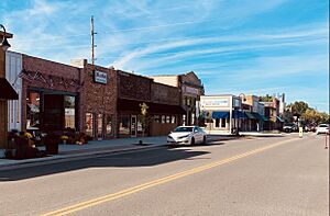
Downtown Annandale
|
|

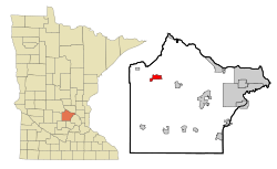
Location of the city of Annandale
within Wright County, Minnesota |
|
| Country | United States |
| State | Minnesota |
| County | Wright |
| Area | |
| • Total | 3.01 sq mi (7.79 km2) |
| • Land | 3.01 sq mi (7.79 km2) |
| • Water | 0.00 sq mi (0.00 km2) |
| Elevation | 1,070 ft (326 m) |
| Population
(2020)
|
|
| • Total | 3,330 |
| • Density | 1,106.68/sq mi (427.26/km2) |
| Time zone | UTC-6 (Central (CST)) |
| • Summer (DST) | UTC-5 (CDT) |
| ZIP code |
55302
|
| Area code(s) | 320 |
| FIPS code | 27-01684 |
| GNIS feature ID | 0639390 |
| Website | www.annandale.mn.us |
Annandale is a city in Wright County, Minnesota, United States. It's often called "The Heart of the Lakes." This is because there are 26 lakes within just 10 miles of the city! In 2020, about 3,330 people lived here.
Contents
History of Annandale
Annandale was officially planned out in 1886. It was named after a place called Annan in Scotland. A post office opened in Annandale in 1887. The city became an official town in 1888.
One special building in Annandale is the Thayer Hotel. It was built in 1895. This hotel is so important that it's listed on the National Register of Historic Places. This means it's a historic site worth protecting.
Annandale's Location and Area
Annandale covers about 3 square miles (7.79 square kilometers) of land. There is no water area within the city limits.
Two main roads, Highway 24 and Highway 55, pass through the city. Annandale is about 50 miles northwest of Minneapolis. It's also about 25 miles south of Saint Cloud. Remember, it's known for its many lakes!
Schools in Annandale
The Annandale School District serves students of all ages. It has four main school buildings. These include Annandale High School, Annandale Middle School, and Annandale Elementary School. There is also a Community Education Center for other learning programs.
Annandale's Population
| Historical population | |||
|---|---|---|---|
| Census | Pop. | %± | |
| 1890 | 211 | — | |
| 1900 | 481 | 128.0% | |
| 1910 | 624 | 29.7% | |
| 1920 | 644 | 3.2% | |
| 1930 | 663 | 3.0% | |
| 1940 | 755 | 13.9% | |
| 1950 | 899 | 19.1% | |
| 1960 | 984 | 9.5% | |
| 1970 | 1,234 | 25.4% | |
| 1980 | 1,568 | 27.1% | |
| 1990 | 2,054 | 31.0% | |
| 2000 | 2,684 | 30.7% | |
| 2010 | 3,228 | 20.3% | |
| 2020 | 3,763 | 16.6% | |
| U.S. Decennial Census | |||
What the 2010 Census Showed
In 2010, the city of Annandale had 3,228 people. There were 1,338 homes, and 819 of these were families. The city had about 1,083 people living per square mile.
Most people living in Annandale were White (96.3%). A small number of people were from other racial backgrounds. About 3.1% of the population was Hispanic or Latino.
About 32% of homes had children under 18 living there. Many homes (46%) were married couples. The average home had 2.33 people. The average family had 2.96 people.
Public Services in Annandale
Annandale has important public services to keep its residents safe.
Fire Department
The Annandale Area Fire Department helps the city and nearby towns. These towns include Albion, Corinna, French Lake, Lynden, and Southside. They respond to fires and other emergencies.
Police Department
The Annandale Police Department works to keep Annandale and its surrounding areas safe. They help with law enforcement and community safety.
See Also
 In Spanish: Annandale (Minnesota) para niños
 | Delilah Pierce |
 | Gordon Parks |
 | Augusta Savage |
 | Charles Ethan Porter |

