Meeker County, Minnesota facts for kids
Quick facts for kids
Meeker County
|
|
|---|---|

|
|

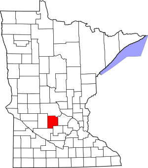
Location within the U.S. state of Minnesota
|
|
 Minnesota's location within the U.S. |
|
| Country | |
| State | |
| Founded | February 23, 1856 |
| Named for | Bradley B. Meeker, an associate justice of Minnesota Territorial Court |
| Seat | Litchfield |
| Largest city | Litchfield |
| Area | |
| • Total | 645 sq mi (1,670 km2) |
| • Land | 608 sq mi (1,570 km2) |
| • Water | 37 sq mi (100 km2) 5.7%% |
| Population
(2020)
|
|
| • Total | 23,400 |
| • Estimate
(2023)
|
23,490 |
| • Density | 38.5/sq mi (14.9/km2) |
| Time zone | UTC−6 (Central) |
| • Summer (DST) | UTC−5 (CDT) |
| Congressional district | 7th |
Meeker County is a county in the state of Minnesota, USA. It is located in the central part of the state. As of the 2020 census, about 23,400 people lived there. The main town and county seat is Litchfield.
Contents
History of Meeker County
Meeker County was created a long time ago, on February 23, 1856. Before it became a county, the land was part of the Minnesota Territory. A "territory" is an area of land that belongs to the United States but is not yet a state.
The county was named after Bradley B. Meeker (1813-1873). He was an important judge in the Minnesota Territory from 1849 to 1853.
When Meeker County was first formed, the town of Forest City was chosen as the county seat. The county seat is the main town where the government offices are located. However, in 1869, the county seat was moved to Litchfield. This happened because a new railroad line, the St. Paul and Pacific Railroad, reached Litchfield, making it an easier place for people to get to.
In 1858, a part of Meeker County was used to create Kandiyohi County. Since then, the borders of Meeker County have stayed the same.
The Dakota War of 1862
An important historical event that happened in Meeker County was the start of the Dakota War of 1862. This conflict began on August 17, 1862, in a place called Acton. Later, there was a battle near Acton where soldiers had to retreat. The Dakota people also attacked Forest City. Today, you can find many monuments in the county that remember the people who were affected by this conflict.
Geography of Meeker County
Meeker County has a landscape of gently rolling hills. It has some wooded areas and many lakes and ponds. Most of the land is used for farming. The highest point in the county is about 1,261 feet (384 meters) above sea level, located southwest of Lake Hope.
The county covers a total area of 645 square miles (1,671 square kilometers). Out of this, 608 square miles (1,575 square kilometers) is land, and 37 square miles (96 square kilometers) is water. This means about 5.7% of the county is covered by water.
Main Roads
Many important roads pass through Meeker County, helping people travel around. These include:
 U.S. Highway 12
 Minnesota State Highway 4
 Minnesota State Highway 7
 Minnesota State Highway 15
 Minnesota State Highway 22
 Minnesota State Highway 24
 Minnesota State Highway 55
Neighboring Counties
Meeker County shares its borders with several other counties:
- Stearns County to the north
- Wright County to the east
- McLeod County to the southeast
- Renville County to the southwest
- Kandiyohi County to the west
Nature Areas
Meeker County has several protected areas where nature is preserved. These are great places to explore and enjoy the outdoors:
- Acton State Wildlife Management Area
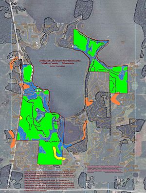
- Greenleaf Lake State Recreation Area
- Greenleaf State Wildlife Management Area
- Knapp State Wildlife Management Area (part)
- Madsen State Wildlife Management Area
- Popular State Wildlife Management Area
- Wieker State Wildlife Management Area
Population of Meeker County
The population of Meeker County has changed over the years. This information comes from the U.S. Census, which counts how many people live in an area every ten years.
| Historical population | |||
|---|---|---|---|
| Census | Pop. | %± | |
| 1860 | 928 | — | |
| 1870 | 6,090 | 556.3% | |
| 1880 | 11,739 | 92.8% | |
| 1890 | 15,456 | 31.7% | |
| 1900 | 17,753 | 14.9% | |
| 1910 | 17,022 | −4.1% | |
| 1920 | 18,103 | 6.4% | |
| 1930 | 17,914 | −1.0% | |
| 1940 | 19,277 | 7.6% | |
| 1950 | 18,966 | −1.6% | |
| 1960 | 18,887 | −0.4% | |
| 1970 | 18,387 | −2.6% | |
| 1980 | 20,594 | 12.0% | |
| 1990 | 20,846 | 1.2% | |
| 2000 | 22,644 | 8.6% | |
| 2010 | 23,300 | 2.9% | |
| 2020 | 23,400 | 0.4% | |
| 2023 (est.) | 23,490 | 0.8% | |
| U.S. Decennial Census 1790-1960 1900-1990 1990-2000 2010-2020 |
|||
Who Lives Here? (2020 Census)
The 2020 census also tells us about the different groups of people living in Meeker County. Most people are White, but there are also people from many other backgrounds.
| Race / Ethnicity | Pop 2010 | Pop 2020 | % 2010 | % 2020 |
|---|---|---|---|---|
| White (not Hispanic) | 22,233 | 21,618 | 95.42% | 92.39% |
| Black or African American (not Hispanic) | 68 | 93 | 0.29% | 0.40% |
| Native American (not Hispanic) | 33 | 37 | 0.14% | 0.16% |
| Asian (not Hispanic) | 59 | 59 | 0.25% | 0.25% |
| Pacific Islander (not Hispanic) | 9 | 2 | 0.04% | 0.01% |
| Other Race (not Hispanic) | 8 | 49 | 0.03% | 0.21% |
| Mixed Race (not Hispanic) | 123 | 592 | 0.53% | 2.53% |
| Hispanic or Latino (any race) | 767 | 950 | 3.29% | 4.06% |
| Total | 23,300 | 23,400 | 100.00% | 100.00% |
Note: The U.S. Census counts Hispanic/Latino as an ethnic group. This table separates them from the racial categories.
Towns and Communities
Meeker County has several towns and smaller communities where people live.
Cities
- Cedar Mills
- Cosmos
- Darwin
- Dassel
- Eden Valley (partly in another county)
- Grove City
- Kingston
- Litchfield (the county seat)
- Watkins
Unincorporated Communities
These are smaller communities that are not officially organized as cities:
Townships
Townships are smaller divisions of the county, often including rural areas and small communities. In 1888, there were 17 townships in Meeker County:
- Acton Township
- Cedar Mills Township
- Collinwood Township
- Cosmos Township
- Danielson Township
- Darwin Township
- Dassel Township
- Ellsworth Township
- Forest City Township
- Forest Prairie Township
- Greenleaf Township
- Harvey Township
- Kingston Township
- Litchfield Township
- Manannah Township
- Swede Grove Township
- Union Grove Township
Notable People from Meeker County
- Magnus Johnson (1871-1936) - He was a local farmer who became a United States Senator for Minnesota from 1923 to 1925.
See also
 In Spanish: Condado de Meeker para niños
 | Jackie Robinson |
 | Jack Johnson |
 | Althea Gibson |
 | Arthur Ashe |
 | Muhammad Ali |


