Kingston, Minnesota facts for kids
Quick facts for kids
Kingston, Minnesota
|
|
|---|---|

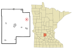
Location in Meeker County and the state of Minnesota
|
|
| Country | United States |
| State | Minnesota |
| County | Meeker |
| Government | |
| • Type | City Council |
| Area | |
| • Total | 0.56 sq mi (1.44 km2) |
| • Land | 0.55 sq mi (1.43 km2) |
| • Water | 0.00 sq mi (0.00 km2) |
| Elevation | 1,017 ft (310 m) |
| Population
(2020)
|
|
| • Total | 184 |
| • Density | 332.13/sq mi (128.29/km2) |
| Time zone | UTC-6 (Central (CST)) |
| • Summer (DST) | UTC-5 (CDT) |
| ZIP code |
55325
|
| Area code(s) | 320 |
| FIPS code | 27-33344 |
| GNIS feature ID | 2395538 |
Kingston is a small city in Meeker County, Minnesota, United States. It is located right next to the North Fork of the Crow River. In 2020, about 184 people lived there.
Contents
The Story of Kingston
Kingston was first planned out and mapped in 1857. This process is called "platting." A post office opened in Kingston in the same year. It helped people send and receive mail until 1907.
In 2013, something interesting happened. People in Kingston had a special election. They voted on whether the city should stop being a city and dissolve. This means it would no longer have its own city government. However, most people voted against it. There were 23 votes to dissolve and 36 votes to stay a city. So, Kingston remained a city.
Kingston's Location and Land
Kingston is found in the northeastern part of Meeker County. A main road, Minnesota State Highway 15, runs along the western edge of the city. If you go north on this highway for about 8 miles, you'll reach Kimball. If you go south the same distance, you'll find Dassel.
Litchfield is another important city nearby. It's about 14 miles southwest of Kingston. Litchfield is the "county seat" for Meeker County. This means it's where the main government offices for the county are located.
The U.S. Census Bureau says Kingston covers about 0.56 square miles of land. Only a tiny part, about 0.001 square miles, is water. The North Fork of the Crow River flows through the city, just south of its main crossroads. This river flows east and eventually joins the Mississippi River.
Who Lives in Kingston?
| Historical population | |||
|---|---|---|---|
| Census | Pop. | %± | |
| 1870 | 56 | — | |
| 1970 | 115 | — | |
| 1980 | 141 | 22.6% | |
| 1990 | 131 | −7.1% | |
| 2000 | 120 | −8.4% | |
| 2010 | 161 | 34.2% | |
| 2020 | 184 | 14.3% | |
| U.S. Decennial Census | |||
The number of people living in Kingston has changed over the years. You can see how the population has grown and shrunk in the table above.
Kingston's Population in 2010
In 2010, there were 161 people living in Kingston. These people lived in 61 different homes, and 42 of these were families.
The city had a population density of about 287.5 people for every square mile. This tells you how crowded an area is. There were also 70 housing units, which means places where people could live.
Most of the people in Kingston were White (96.9%). A small number were Native American (0.6%), Asian (0.6%), or from two or more races (1.9%). About 1.9% of the population identified as Hispanic or Latino.
Out of the 61 homes, 36.1% had children under 18 living there. Most homes (60.7%) had married couples living together. A small number had a female head of household without a husband (6.6%), or a male head of household without a wife (1.6%). About 31.1% of homes were not families.
About 21.3% of all homes had just one person living there. Only 4.9% of homes had someone living alone who was 65 years old or older. On average, there were 2.64 people in each home and 3.10 people in each family.
The average age of people in Kingston was 30.4 years old. About 29.2% of residents were under 18. Another 8% were between 18 and 24 years old. About 29.2% were between 25 and 44. Then, 22.3% were between 45 and 64. Finally, 11.2% were 65 years old or older.
When it came to gender, 55.3% of the people in Kingston were male. The other 44.7% were female.
See also
 In Spanish: Kingston (Minnesota) para niños
 | Claudette Colvin |
 | Myrlie Evers-Williams |
 | Alberta Odell Jones |

