Monticello, Minnesota facts for kids
Quick facts for kids
Monticello
|
|
|---|---|

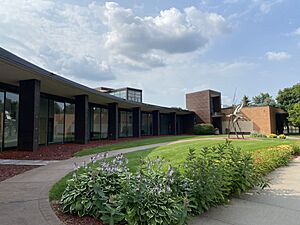
Monticello City Hall/Community Center
|
|

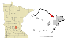
Location of the city of Monticello
within Wright County, Minnesota |
|
| Country | United States |
| State | Minnesota |
| County | Wright |
| Settled | 1852 |
| Platted | 1854 |
| Founded | March 1, 1856 |
| Incorporated (village) | March 9, 1875 |
| Incorporated (city) | April 30, 1906 |
| Area | |
| • Total | 9.33 sq mi (24.17 km2) |
| • Land | 9.00 sq mi (23.32 km2) |
| • Water | 0.33 sq mi (0.86 km2) |
| Elevation | 929 ft (283 m) |
| Population
(2020)
|
|
| • Total | 14,455 |
| • Estimate
(2022)
|
14,804 |
| • Density | 1,605.75/sq mi (619.97/km2) |
| Time zone | UTC–6 (Central (CST)) |
| • Summer (DST) | UTC–5 (CDT) |
| ZIP code |
55362
|
| Area code(s) | 763 |
| FIPS code | 27-43774 |
| GNIS feature ID | 0648048 |
| Sales tax | 7.375% |
Monticello (pronounced MON-tiss-EL-oh) is a city in Minnesota, United States. It is located right next to the famous Mississippi River. Monticello is part of Wright County. In 2020, about 14,455 people lived there.
Contents
Exploring Monticello's Location and Parks
Monticello is located in the Central Time Zone. The city covers about 23.32 square kilometers (9.00 square miles) of land. Its elevation is 283 meters (929 feet) above sea level.
Monticello's Parks and Trails
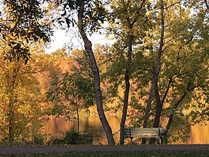
Monticello has many parks and a great system of trails. There are 28 city-owned parks for everyone to enjoy. You can find miles of winding trails perfect for walking or biking. Some of the biggest parks include Lake Maria State Park, Montissippi Regional Park, and Harry Larsen Memorial Park.
At Swan Park, something special happens every winter. From December to March, up to 2,700 trumpeter swans gather there. They like this spot because the Mississippi River water is warmed by the nearby Monticello Nuclear Generating Plant.
The city and Wright County also worked together to protect a large natural area. This area is called the Bertram Chain of Lakes. It has four lakes and lots of untouched shoreline and forests. About 812 acres are open for public use. You can explore 4 miles of hiking trails and 10 miles of mountain biking trails. There's also a beach at Bertram Lake for swimming. You can even paddle on Long, Mud, and First Lakes. In winter, people enjoy fat-biking, snowshoeing, and cross-country skiing. Summer activities include paddleboard classes and guided moonlight hikes.
A Look at Monticello's Past
Monticello was first mapped out in 1854. A post office opened there in 1855. The city officially became a town in 1856. Later, in 1891, a nearby village called Moritzious joined with Monticello.
In 1971, the Monticello Nuclear Generating Plant started working. This plant helps produce electricity.
In May 2006, the Monticello Middle School had a problem. A lot of rain caused an electrical fire on the roof. The smoke damaged the school, so it had to close for the rest of the school year. Middle school and high school students shared the high school building. They went to school on alternating days. The clean-up was finished in time for the next school year.
Monticello's Economy and Growth
Monticello has been planning for growth for a long time. In 1996, the city made a plan to handle its growing population. A new high school was built in 1999. In 2006, a new highway exit was finished. This made it easier for people to get to Interstate 94.
Since 2002, many new stores have opened. This planned growth has also brought new car dealerships, hotels, and businesses. An agreement in 2004 with Monticello Township is expected to help the city continue to grow for many years.
Major Employers in Monticello
Many companies provide jobs in Monticello. Here are some of the top employers in the city, based on a 2021 report:
| # | Employer | # of Employees |
|---|---|---|
| 1 | Xcel Energy | 600 |
| 2 | Monticello School District | 576 |
| 3 | CentraCare Medical Center | 500 |
| 4 | Cargill Kitchen Solutions | 350 |
| 5 | Wal-Mart Supercenter | 300 |
| 6 | City of Monticello | 230 |
| 7* | Home Depot | 150 |
| 7* | Target | 150 |
| 9 | Ultra Machine Corporation | 140 |
| 10* | Cub Foods | 100 |
| 10* | WSI Industries, Inc. | 100 |
- denotes tied ranks
Learning in Monticello
Monticello is part of the Monticello School District. Some parts of nearby Monticello Township are in the St. Michael-Albertville Schools district.
Monticello High School is one of the largest schools in Wright County. About 1,314 students attend the high school. The school's sports teams are known as the Magic.
Monticello's Population Over Time
| Historical population | |||
|---|---|---|---|
| Census | Pop. | %± | |
| 1880 | 290 | — | |
| 1890 | 503 | 73.4% | |
| 1900 | 818 | 62.6% | |
| 1910 | 858 | 4.9% | |
| 1920 | 1,024 | 19.3% | |
| 1930 | 924 | −9.8% | |
| 1940 | 1,076 | 16.5% | |
| 1950 | 1,231 | 14.4% | |
| 1960 | 1,477 | 20.0% | |
| 1970 | 1,636 | 10.8% | |
| 1980 | 2,830 | 73.0% | |
| 1990 | 4,941 | 74.6% | |
| 2000 | 7,868 | 59.2% | |
| 2010 | 12,759 | 62.2% | |
| 2020 | 14,455 | 13.3% | |
| 2022 (est.) | 14,804 | 16.0% | |
| U.S. Decennial Census 2020 Census |
|||
| Historical population | |||
|---|---|---|---|
| Census | Pop. | %± | |
| 1880 | 104 | — | |
| 1890 | 161 | 54.8% | |
| U.S. Census for Moritzious | |||
Population Facts from 2010
In 2010, Monticello had 12,759 people living in 4,693 households. About 43.1% of these households had children under 18. The average household size was 2.68 people. The average age of people in the city was 31.4 years. About 30.8% of residents were under 18 years old.
Local News
Newspapers in Monticello
The main local newspaper for Monticello is called The Monticello Times.
Famous People from Monticello
- Tobias Mealey – An early pioneer and politician in Minnesota. He was important in the building of the Rand House in Monticello for his daughter.
- Joel Przybilla – A professional basketball player who played for the Milwaukee Bucks in the NBA. He graduated from Monticello High School.
See also
 In Spanish: Monticello (Minnesota) para niños
 | Janet Taylor Pickett |
 | Synthia Saint James |
 | Howardena Pindell |
 | Faith Ringgold |


