South Haven, Minnesota facts for kids
Quick facts for kids
South Haven
|
|
|---|---|
|
City
|
|

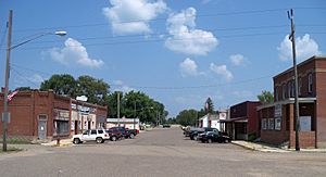
Downtown South Haven
|
|

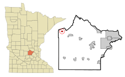
Location of South Haven
within Wright County, Minnesota |
|
| Country | United States |
| State | Minnesota |
| County | Wright |
| Area | |
| • Total | 0.64 sq mi (1.65 km2) |
| • Land | 0.64 sq mi (1.65 km2) |
| • Water | 0.00 sq mi (0.00 km2) |
| Elevation | 1,109 ft (338 m) |
| Population
(2020)
|
|
| • Total | 185 |
| • Density | 291.34/sq mi (112.43/km2) |
| Time zone | UTC-6 (Central (CST)) |
| • Summer (DST) | UTC-5 (CDT) |
| ZIP code |
55382
|
| Area code(s) | 320 |
| FIPS code | 27-61402 |
| GNIS feature ID | 0652314 |
South Haven is a small city located in Wright County, Minnesota, United States. In 2020, about 185 people lived there. It's a quiet place with a rich history and a close-knit community.
You can find more information about South Haven on its official website here.
Contents
South Haven's History: How It Started
South Haven was officially planned and marked out in 1888. This happened when the railroad tracks were extended to reach that spot. The city got its name because it is located in Southside Township. It is also directly south of Fair Haven Township.
A post office has been open in South Haven since 1887. The city officially became an incorporated city in 1902. This means it gained its own local government.
Where is South Haven Located?
South Haven is in the northwestern part of Wright County, Minnesota. The city covers a total area of about 0.63 square miles (1.65 square kilometers). All of this area is land, with no water.
Main roads in the area include Minnesota State Highways 24 and 55. These two highways run together through the community. Nearby towns include Annandale, Maple Lake, and Kimball.
Who Lives in South Haven?
This section shares information about the people who live in South Haven. This data comes from official counts of the population, called censuses.
| Historical population | |||
|---|---|---|---|
| Census | Pop. | %± | |
| 1910 | 287 | — | |
| 1920 | 346 | 20.6% | |
| 1930 | 289 | −16.5% | |
| 1940 | 276 | −4.5% | |
| 1950 | 305 | 10.5% | |
| 1960 | 328 | 7.5% | |
| 1970 | 238 | −27.4% | |
| 1980 | 205 | −13.9% | |
| 1990 | 193 | −5.9% | |
| 2000 | 204 | 5.7% | |
| 2010 | 187 | −8.3% | |
| 2020 | 185 | −1.1% | |
| U.S. Decennial Census | |||
South Haven's Population in 2010
According to the 2010 census, 187 people lived in South Haven. There were 70 households, which are groups of people living together. Out of these, 48 were families.
The city had about 297 people per square mile (115 people per square kilometer). Most residents, about 93.6%, were White. Other groups included African American, Native American, and Asian people. Some residents were from other races or a mix of two or more races. About 4.8% of the population was Hispanic or Latino.
Many households (41.4%) had children under 18 living with them. Most households (58.6%) were married couples living together. About 27.1% of all households were made up of individuals living alone. This included 11.4% who were 65 years old or older. The average household had 2.67 people. The average family had 3.33 people.
The average age of people in the city was 33.8 years old. About 33.7% of residents were under 18. People aged 65 or older made up 14.4% of the population. The city had slightly more males (51.9%) than females (48.1%).
South Haven in Pop Culture
In 2009, a music group called Element One created a song named "South Haven." It was a type of electronic music called progressive trance. You can learn more about the song here.
See also
 In Spanish: South Haven (Minnesota) para niños
 | Victor J. Glover |
 | Yvonne Cagle |
 | Jeanette Epps |
 | Bernard A. Harris Jr. |

