Sherburne National Wildlife Refuge facts for kids
Quick facts for kids Sherburne National Wildlife Refuge |
|
|---|---|
|
IUCN Category IV (Habitat/Species Management Area)
|
|

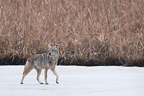
Coyote walking on iced-over pond at Sherburne National Wildlife Refuge on March 25, 2020
|
|
| Location | Sherburne County, Minnesota |
| Nearest city | Zimmerman, Minnesota |
| Area | 30,700 acres (124 km2) |
| Established | May 18, 1965 |
| Governing body | U.S. Fish and Wildlife Service |
| Website | Sherburne National Wildlife Refuge |
Imagine a special place where wild animals can live safely and freely! The Sherburne National Wildlife Refuge is one such amazing spot in Sherburne County, Minnesota. It's a huge protected area, about 30,700 acres (that's over 124 square kilometers!), set aside by the United States government.
This refuge is home to many different types of nature, like open grassy areas called oak savanna, thick forests known as Big Woods, and watery wetlands. The St. Francis River even flows right through it! Because of all these different habitats, the refuge is bursting with life. Over 230 kinds of birds, 58 types of mammals, and 25 species of reptiles and amphibians have been seen here.
Contents
A Look Back: History of the Refuge
People have lived in the area that is now Sherburne National Wildlife Refuge for a very long time. We know that Native American villages were here as far back as 1300 CE. It's likely they lived here even earlier! The mix of different habitats and lots of water made it a perfect place for many kinds of wildlife to thrive.
European settlers started arriving in the 1870s. As more land was used for farming, people stopped natural wildfires. They also dug ditches to drain wet areas. This changed the land, making fewer wetlands that stayed wet all year. It also made the wooded areas much thicker.
How the Refuge Was Created
By the 1940s, people who cared about nature and hunting realized how special this area used to be. They saw its potential to become a great wildlife home again. Minnesota's conservation department looked into making it a state wildlife area. However, the state didn't have enough money to buy the land from its nearly 300 different owners.
So, in 1960, they asked the United States Fish and Wildlife Service to consider protecting the site at a national level. This idea was officially approved on May 18, 1965. The government then started buying land for the refuge. They used money from selling special duck stamps to help pay for it.
Exploring the Refuge: Fun Activities
Sherburne National Wildlife Refuge offers many ways to enjoy nature! It's a great place for outdoor adventures.
Winter Fun
In winter, most of the refuge is open for exciting activities like:
- Cross-country skiing
- Snowshoeing
- Hiking
Spring and Summer Exploration
From March 1 to August 31, some areas are restricted. This helps protect wildlife during their breeding season. But don't worry, there are still many places to explore:
- Prairie's Edge Wildlife Drive: This 7.3-mile (11.7 km) gravel road is open from late April through October. You can drive, bike, or walk along it. It winds through wetlands and prairies. There are three observation decks and three short hiking loops along the way.
- Blue Hill Trail: This trail has three loops. A short path leads to the top of Blue Hill, which is 90 feet (27 meters) high. It's the highest point in the refuge!
- Mahnomen Trail: This trail has three connected loops. They take you through wooded upland areas.
- Canoeing: You can canoe on a part of the St. Francis River and its smaller stream, Battle Brook.
- Fishing: There are special spots where you can go fishing.
Other Activities
Hikers are allowed to pick berries and mushrooms for themselves. Just make sure to stay within 100 feet of the trails. In the fall, there are special hunting seasons for big game, small game, and waterfowl.
Remember, the entire refuge is only for day-use. This means you can't stay overnight. If you want to camp, there's a campground nearby in the Sand Dunes State Forest.
Images for kids
 | Shirley Ann Jackson |
 | Garett Morgan |
 | J. Ernest Wilkins Jr. |
 | Elijah McCoy |


