Columbus, Minnesota facts for kids
Quick facts for kids
Columbus
|
|
|---|---|
| Motto(s):
"Rural Nature. Urban Access."
|
|

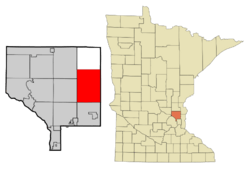
Location of the city of Columbus
within Anoka County, Minnesota |
|
| Country | United States |
| State | Minnesota |
| County | Anoka |
| Incorporated | September 21, 2006 |
| Area | |
| • Total | 47.69 sq mi (123.51 km2) |
| • Land | 44.85 sq mi (116.16 km2) |
| • Water | 2.84 sq mi (7.35 km2) |
| Elevation | 906 ft (276 m) |
| Population
(2020)
|
|
| • Total | 4,159 |
| • Density | 92.73/sq mi (35.80/km2) |
| Time zone | UTC-6 (Central (CST)) |
| • Summer (DST) | UTC-5 (CDT) |
| ZIP code |
55025
|
| Area code(s) | 651 |
| FIPS code | 27-12718 |
| GNIS feature ID | 2393610 |
| Website | www.ci.columbus.mn.us |
Columbus is a city located in Anoka County, Minnesota, in the United States. In 2020, about 4,159 people lived there.
Contents
History of Columbus City
Columbus was once known as Columbus Township. It officially became the City of Columbus on September 21, 2006. This change happened because people were worried that the nearby city of Forest Lake might try to take over parts of the township.
Mel Mettler was the first mayor of Columbus. He was reelected in 2008. Later, Jesse Preiner became mayor in 2019.
A special place called Running Aces Harness Park opened in Columbus in April 2008. It's a track where harness horse racing takes place.
Geography and Nature
Columbus covers an area of about 47.76 square miles (123.7 square kilometers). Most of this area is land, with a smaller part being water.
Several main roads run through Columbus, including Anoka County Roads 18, 19, 23, 54, and 62. A major highway, Interstate 35, also splits into two parts (35E and 35W) in the southeastern part of the city. This split is often called the Forest Lake Split.
Nature is important in Columbus. Rice Creek flows through the city. Also, the Carlos Avery Wildlife Area, a place for wildlife, is located in the northern and western parts of Columbus.
Columbus is close to several other towns. These include Forest Lake, Lino Lakes, Ham Lake, East Bethel, and Wyoming.
Population Information
| Historical population | |||
|---|---|---|---|
| Census | Pop. | %± | |
| 1860 | 119 | — | |
| 1870 | 71 | −40.3% | |
| 1880 | 92 | 29.6% | |
| 1890 | 262 | 184.8% | |
| 1900 | 484 | 84.7% | |
| 1910 | 585 | 20.9% | |
| 1920 | 569 | −2.7% | |
| 1930 | 597 | 4.9% | |
| 1940 | 658 | 10.2% | |
| 1950 | 748 | 13.7% | |
| 1960 | 908 | 21.4% | |
| 1970 | 1,999 | 120.2% | |
| 1980 | 3,232 | 61.7% | |
| 1990 | 3,690 | 14.2% | |
| 2000 | 3,957 | 7.2% | |
| 2010 | 3,914 | −1.1% | |
| 2020 | 4,159 | 6.3% | |
| U.S. Decennial Census | |||
2010 Census Details
In 2010, the city of Columbus had 3,914 people living there. There were 1,416 households and 1,119 families. On average, there were about 87 people per square mile.
Most of the people in Columbus were White (93.6%). There were also smaller groups of African American (0.7%), Native American (0.6%), and Asian (3.6%) residents. About 1.6% of the population identified as Hispanic or Latino.
In terms of households, about 31.3% had children under 18 living with them. Most households (69.1%) were married couples living together. The average household had 2.76 people.
The average age of people in Columbus was 45.3 years. About 22.3% of residents were under 18 years old. About 11.2% were 65 years or older. The population was almost evenly split between males (51.9%) and females (48.1%).
See also
 In Spanish: Columbus (Minnesota) para niños
 | Shirley Ann Jackson |
 | Garett Morgan |
 | J. Ernest Wilkins Jr. |
 | Elijah McCoy |

