Manomin County, Minnesota facts for kids
Quick facts for kids
Manomin County
|
|
|---|---|
 |
|

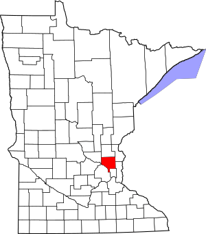
Location within the U.S. state of Minnesota
|
|
 Minnesota's location within the U.S. |
|
| Country | |
| State | |
| Founded | May 23, 1857 |
| Named for | Ojibway word for wild rice |
| Seat | Manomin |
| Largest city | Manomin |
| Area | |
| • Total | 16 sq mi (40 km2) |
| Population | |
| • Estimate
(1860)
|
136 |
Manomin County was a small county in Minnesota. It existed for 13 years, from 1857 to 1869. The land was first separated from Ramsey County. When it was formed, it was the smallest county in the United States. It covered about 16 square miles.
The county included Fridley Township. This township was named after Abram M. Fridley, a Minnesota legislator. Abram Fridley was the leader of the county commissioners. In 1860, the county had a population of 136 people. Manomin County was later joined with Anoka County in 1869.
Today, this land makes up a unique part of Anoka County. It extends south between Hennepin and Ramsey counties. Manomin County Park in Fridley is near the old Manomin town site. This park is located where Rice Creek meets the Mississippi River.
Manomin is a different way to spell manoomin. This is an Ojibwe word for wild rice. Wild rice was a very important food for the Ojibwe people. Another Minnesota county, Mahnomen, was created in 1906 and has a similar name.
History of Manomin County
Manomin County was created on May 23, 1857. This happened when the Fridley township sections were separated from Ramsey County. The main town, or county seat, was Manomin. Today, this area is known as Fridley. Another county, Buchanan County, was also created in Minnesota on the same day.
Manomin County was later dissolved in 1858. Its administration was then handled by St. Louis County. In 1860, it became attached to Anoka County. At that time, the area had 136 residents. By 1863, it was attached to Hennepin County.
To solve the county's issues, a change was made to the state constitution. This change allowed Manomin County to become part of Anoka County. Voters approved this change on November 2, 1869, with strong support.
Henry C. Fridley, the son of legislator Abram M. Fridley, later explained the situation. He said that a county so small and with few people found it hard to operate. It was difficult to get rid of the county because of a rule about county sizes. The constitutional change was the only way to solve this problem.
Geography of Manomin County
The area that was once Manomin County now includes parts of several cities. These cities are Fridley, Columbia Heights, Hilltop, and a small part of Spring Lake Park. It also includes a small part of Coon Rapids.
The county's original boundaries were described in a specific way. It started in the middle of the Mississippi River. Then it followed certain lines to create its shape. Six of the county's 18 sections were bordered by the Mississippi River. These sections were smaller than a full section of land.
 | William L. Dawson |
 | W. E. B. Du Bois |
 | Harry Belafonte |

