Traill County, North Dakota facts for kids
Quick facts for kids
Traill County
|
|
|---|---|

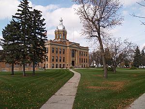
Traill County Courthouse
|
|

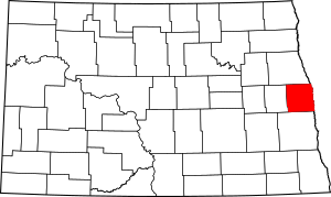
Location within the U.S. state of North Dakota
|
|
 North Dakota's location within the U.S. |
|
| Country | |
| State | |
| Founded | January 12, 1875 (created) February 23, 1875 (organized) |
| Named for | Walter John Strickland Traill |
| Seat | Hillsboro |
| Largest city | Mayville |
| Area | |
| • Total | 863 sq mi (2,240 km2) |
| • Land | 862 sq mi (2,230 km2) |
| • Water | 0.6 sq mi (2 km2) 0.07% |
| Population
(2020)
|
|
| • Total | 7,997 |
| • Estimate
(2022)
|
7,958 |
| • Density | 9.267/sq mi (3.5778/km2) |
| Time zone | UTC−6 (Central) |
| • Summer (DST) | UTC−5 (CDT) |
| Congressional district | At-large |
| Website | http://www.co.traill.nd.us |
Traill County is a place in North Dakota, a state in the United States. In 2020, about 7,997 people lived there. The main town, called the county seat, is Hillsboro. The biggest city in the county is Mayville.
Contents
History of Traill County
Traill County was created on January 12, 1875. This happened when the government of Dakota Territory decided to make a new county. They used parts of other counties like Barnes, Cass, and Grand Forks.
The county was named after Walter John Strickland Traill. He worked for the Hudson's Bay Company, which was a big trading company. His mother was a famous Canadian pioneer named Catharine Parr Traill.
County Seat Changes
The first building for the county government was a small one in Caledonia. Over time, new courthouses were built. People voted several times to move the county seat to Mayville, but those votes did not pass.
Later, people tried to move the county seat to Hillsboro. This effort was successful. All the county's important papers and records were moved to Hillsboro in 1890. The building that is used today was started in 1905. It is now a special historical place.
The county's borders changed a little in 1881 and 1883. They have stayed the same since 1883.
Geography of Traill County
Traill County is located on the eastern side of North Dakota. Its eastern border is right next to the state of Minnesota. The Red River flows along this eastern border.
Rivers and Land
The Goose River flows through the middle of the county. It eventually empties into the Red River. The Elk River also flows through the southwestern part of the county.
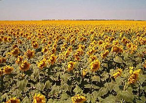
The land in Traill County has gentle rolling hills. Most of the land is used for farming. The land slopes down towards the east and north. The highest point in the county is about 1,201 feet (366 meters) above sea level. The county covers a total area of 863 square miles (2,235 square kilometers). Most of this is land, with only a small amount of water.
Main Roads
Airports
- Hillsboro Municipal Airport (3H4)
- Mayville Municipal Airport (D56)
Neighboring Counties
- Grand Forks County - north
- Polk County, Minnesota - northeast
- Norman County, Minnesota - east
- Cass County - south
- Steele County - west
People of Traill County (Demographics)
Demographics is the study of people living in a certain area. It looks at things like how many people there are, their ages, and their backgrounds.
| Historical population | |||
|---|---|---|---|
| Census | Pop. | %± | |
| 1880 | 4,123 | — | |
| 1890 | 10,217 | 147.8% | |
| 1900 | 13,107 | 28.3% | |
| 1910 | 12,545 | −4.3% | |
| 1920 | 12,210 | −2.7% | |
| 1930 | 12,600 | 3.2% | |
| 1940 | 12,300 | −2.4% | |
| 1950 | 11,359 | −7.7% | |
| 1960 | 10,583 | −6.8% | |
| 1970 | 9,571 | −9.6% | |
| 1980 | 9,624 | 0.6% | |
| 1990 | 8,752 | −9.1% | |
| 2000 | 8,477 | −3.1% | |
| 2010 | 8,121 | −4.2% | |
| 2020 | 7,997 | −1.5% | |
| 2022 (est.) | 7,958 | −2.0% | |
| U.S. Decennial Census 1790-1960 1900-1990 1990-2000 2010-2020 |
|||
Population in 2020
According to the census in 2020, there were 7,997 people living in Traill County.
Population in 2010
In the 2010 census, there were 8,121 people. About 96.2% of the people were white. Other groups included American Indian, Black or African American, and Asian people. About 2.6% of the population was of Hispanic or Latino background.
Many people in Traill County have Norwegian (53.2%) or German (38.1%) family backgrounds. The average age of people in the county was about 42.6 years old.
The average income for a family in the county was about $60,054 per year. About 9.2% of all people in the county lived below the poverty line. This included 10.9% of those under 18 years old.
Communities in Traill County

Cities
Other Places to Live
- Blanchard (a census-designated place)
- Caledonia (a census-designated place)
- Cummings (a small, unincorporated community)
Townships
- Belmont
- Bingham
- Blanchard
- Bloomfield
- Bohnsack
- Buxton
- Caledonia
- Eldorado
- Elm River
- Ervin
- Galesburg
- Garfield
- Greenfield
- Herberg
- Hillsboro
- Kelso
- Lindaas
- Mayville
- Morgan
- Norman
- Norway
- Roseville
- Stavanger
- Viking
- Wold
Images for kids
See also
 In Spanish: Condado de Traill para niños
 | Bayard Rustin |
 | Jeannette Carter |
 | Jeremiah A. Brown |


