Grand Forks County, North Dakota facts for kids
Quick facts for kids
Grand Forks County
|
|
|---|---|

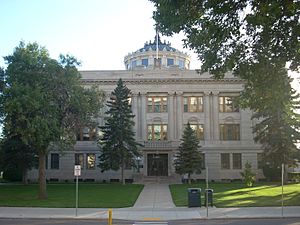
Grand Forks County Courthouse
|
|

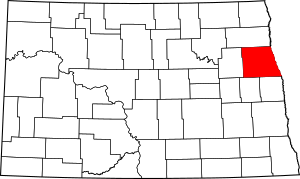
Location within the U.S. state of North Dakota
|
|
 North Dakota's location within the U.S. |
|
| Country | |
| State | |
| Founded | January 4, 1873 (created) March 2, 1875 (organized) |
| Seat | Grand Forks |
| Largest city | Grand Forks |
| Area | |
| • Total | 1,439.418 sq mi (3,728.08 km2) |
| • Land | 1,436.216 sq mi (3,719.78 km2) |
| • Water | 3.202 sq mi (8.29 km2) 0.2%% |
| Population
(2020)
|
|
| • Total | 73,170 |
| • Estimate
(2023)
|
72,708 |
| • Density | 50.634/sq mi (19.550/km2) |
| Time zone | UTC−6 (Central) |
| • Summer (DST) | UTC−5 (CDT) |
| Congressional district | At-large |
Grand Forks County is a county located in North Dakota, a state in the United States. In 2020, about 73,170 people lived here, making it the third largest county in North Dakota by population. The main city and place where the county government is located is Grand Forks.
Contents
History of Grand Forks County
Grand Forks County was first created on January 4, 1873, by the government of the Dakota Territory. It was made from land that used to be part of Pembina County. At first, it didn't have its own official government setup.
The county's government was officially organized on March 2, 1875. This meant it could start managing its own affairs. The county's borders changed a few times in the late 1800s, but they have stayed the same since 1883.
Grand Forks County is part of a larger area called the Grand Forks Metropolitan Statistical Area. This area includes parts of both North Dakota and Minnesota.
Geography and Nature
Grand Forks County is located on the eastern side of North Dakota. Its eastern border is right next to Minnesota, with the Red River flowing between them. This river travels north towards Lake Winnipeg and then to Hudson Bay.
The land in Grand Forks County has gentle, rolling hills. Most of the land is used for farming, except for the areas where cities are built. The land generally slopes down towards the north and east. The highest point in the county is a hill in the southwest corner, which is about 1,450 feet (442 meters) above sea level.
The county covers about 1,439 square miles (3,728 square kilometers) in total. Most of this is land (about 1,436 square miles or 3,719 square kilometers), with a small amount of water (about 3.2 square miles or 8.3 square kilometers).
Wildlife and Research
The University of North Dakota has a special Field Biology Station on the Forest River, near the county's northern border. In 2013, they teamed up with the North Dakota Game & Fish Department to create a 160-acre (0.65 square kilometer) wildlife management area there. This area helps scientists study animals like whitetail deer.
The station also works to find and identify plants that naturally grow in the area. So far, they have found 498 different types of plants at the Forest River Biology Station and Wildlife Management Area.
Main Roads and Transportation
Public Transit Options
- Amtrak Empire Builder (train service at Grand Forks station)
- Cities Area Transit (local bus service)
- Jefferson Lines (intercity bus service)
Neighboring Counties
- Walsh County - north
- Marshall County, Minnesota - northeast
- Polk County, Minnesota - east
- Traill County - southeast
- Steele County - southwest
- Nelson County - west
Parks and Protected Areas
- Forest River Biology Station/Wildlife Management Area
- Grand Forks County Larimore Dam Recreation Area
- Kellys Slough National Wildlife Refuge
- Little Goose National Wildlife Refuge
- Prairie Chicken State Game Management Area
- Turtle River State Park
Lakes and Dams
- Fordville Dam
- Larimore Dam
- Smith Lakes
People and Population (Demographics)
| Historical population | |||
|---|---|---|---|
| Census | Pop. | %± | |
| 1880 | 6,248 | — | |
| 1890 | 18,357 | 193.8% | |
| 1900 | 24,459 | 33.2% | |
| 1910 | 27,888 | 14.0% | |
| 1920 | 28,795 | 3.3% | |
| 1930 | 31,956 | 11.0% | |
| 1940 | 34,518 | 8.0% | |
| 1950 | 39,448 | 14.3% | |
| 1960 | 48,677 | 23.4% | |
| 1970 | 61,102 | 25.5% | |
| 1980 | 66,100 | 8.2% | |
| 1990 | 70,683 | 6.9% | |
| 2000 | 66,109 | −6.5% | |
| 2010 | 66,861 | 1.1% | |
| 2020 | 73,170 | 9.4% | |
| 2023 (est.) | 72,708 | 8.7% | |
| U.S. Decennial Census 1790-1960 1900-1990 1990-2000 2010-2020 |
|||
In early 2024, the average value of a home in Grand Forks County was about $279,430.
According to a 2023 survey, there are about 32,099 households in Grand Forks County. On average, each household has about 2.11 people. The average income for a household was around $72,536. About 13.3% of the people in the county live below the poverty line.
About 72.3% of the people in Grand Forks County have jobs. Many adults are well-educated: 34.9% have a bachelor's degree or higher, and 96.9% have a high school diploma. The average age of people in the county is 30.8 years old.
Population Changes Over Time
This chart shows how the population of Grand Forks County has changed over many years, from 1880 to 2023.

Cities and Communities
Cities in Grand Forks County
Census-Designated Places (CDPs)
- Grand Forks AFB (This is a community identified by the Census Bureau for statistical purposes.)
Other Small Communities
Townships
Townships are smaller local government areas within the county.
- Agnes
- Allendale
- Americus
- Arvilla
- Avon
- Bentru
- Blooming
- Brenna
- Chester
- Elkmount
- Elm Grove
- Fairfield
- Falconer
- Ferry
- Gilby
- Grace
- Grand Forks
- Hegton
- Inkster
- Johnstown
- Lakeville
- Larimore
- Levant
- Lind
- Logan Center
- Loretta
- Mekinock
- Michigan
- Moraine
- Niagara
- Northwood
- Oakville
- Pleasant View
- Plymouth
- Rye
- Strabane
- Turtle River
- Union
- Walle
- Washington
- Wheatfield
Education
Here are the school districts that serve students in Grand Forks County:
K-12 School Districts
These districts offer education from kindergarten through 12th grade:
- Dakota Prairie Public School District 1
- Central Valley Public School District 3
- Fordville-Lankin Public School District 5
- Grand Forks Public School District 1
- Grand Forks AFB Public School District 140
- Hatton Public School District 7
- Larimore Public School District 44
- Midway Public School District 128
- Northwood Public School District 129
- Thompson Public School District 61
Elementary School Districts
These districts focus on elementary education:
- Emerado Public School District 127
- Manvel Public School District 125
See also
 In Spanish: Condado de Grand Forks para niños
 | Lonnie Johnson |
 | Granville Woods |
 | Lewis Howard Latimer |
 | James West |


