Larimore, North Dakota facts for kids
Quick facts for kids
Larimore, North Dakota
|
|
|---|---|

Larimore Museum
|
|

Location of Larimore, North Dakota
|
|
| Country | United States |
| State | North Dakota |
| County | Grand Forks |
| Metro | Greater Grand Forks |
| Founded | 1881 |
| Area | |
| • Total | 0.60 sq mi (1.56 km2) |
| • Land | 0.60 sq mi (1.56 km2) |
| • Water | 0.00 sq mi (0.00 km2) |
| Elevation | 1,132 ft (345 m) |
| Population
(2020)
|
|
| • Total | 1,260 |
| • Estimate
(2022)
|
1,223 |
| • Density | 2,096.51/sq mi (809.01/km2) |
| Time zone | UTC-6 (Central (CST)) |
| • Summer (DST) | UTC-5 (CDT) |
| ZIP code |
58251
|
| Area code(s) | 701 |
| FIPS code | 38-45020 |
| GNIS feature ID | 1036120 |
| Highways | ND 18 |
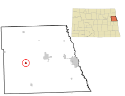
Larimore is a small city in Grand Forks County, North Dakota, in the United States. It is located near where two main roads, U.S. Route 2 and North Dakota Highway 18, meet. Larimore is part of a larger area called "Greater Grand Forks". In 2020, about 1,260 people lived there.
Contents
History of Larimore
Larimore was started in 1881. This happened after a railroad was built through the area. The city is named after N. G. Larimore. He owned a very large farm nearby.
Geography and Climate
Larimore covers a total area of about 0.6 square miles (1.56 square kilometers). All of this area is land.
Larimore's Weather Patterns
The weather in Larimore changes a lot with the seasons. Summers are warm to hot and can be humid. Winters are cold, sometimes very cold. This type of weather is called a humid continental climate.
| Climate data for Larimore, North Dakota | |||||||||||||
|---|---|---|---|---|---|---|---|---|---|---|---|---|---|
| Month | Jan | Feb | Mar | Apr | May | Jun | Jul | Aug | Sep | Oct | Nov | Dec | Year |
| Record high °F (°C) | 60 (16) |
67 (19) |
85 (29) |
100 (38) |
107 (42) |
105 (41) |
111 (44) |
104 (40) |
109 (43) |
92 (33) |
77 (25) |
63 (17) |
111 (44) |
| Mean daily maximum °F (°C) | 14.5 (−9.7) |
19.8 (−6.8) |
33.0 (0.6) |
52.2 (11.2) |
67.0 (19.4) |
75.7 (24.3) |
81.4 (27.4) |
80.2 (26.8) |
69.7 (20.9) |
56.2 (13.4) |
35.6 (2.0) |
21.3 (−5.9) |
50.6 (10.3) |
| Mean daily minimum °F (°C) | −5.2 (−20.7) |
−0.8 (−18.2) |
13.3 (−10.4) |
28.9 (−1.7) |
40.7 (4.8) |
51.2 (10.7) |
55.9 (13.3) |
53.3 (11.8) |
43.7 (6.5) |
32.6 (0.3) |
17.3 (−8.2) |
2.8 (−16.2) |
27.8 (−2.3) |
| Record low °F (°C) | −42 (−41) |
−41 (−41) |
−30 (−34) |
−10 (−23) |
−3 (−19) |
24 (−4) |
34 (1) |
30 (−1) |
18 (−8) |
−6 (−21) |
−27 (−33) |
−36 (−38) |
−42 (−41) |
| Average precipitation inches (mm) | 0.5 (13) |
0.5 (13) |
0.8 (20) |
1.4 (36) |
2.5 (64) |
3.4 (86) |
3.1 (79) |
2.7 (69) |
2.0 (51) |
1.3 (33) |
0.5 (13) |
0.8 (20) |
19.5 (497) |
Population Changes Over Time
The number of people living in Larimore has changed over the years. You can see how the population has grown and shrunk in the table below.
| Historical population | |||
|---|---|---|---|
| Census | Pop. | %± | |
| 1890 | 553 | — | |
| 1900 | 1,235 | 123.3% | |
| 1910 | 1,224 | −0.9% | |
| 1920 | 1,089 | −11.0% | |
| 1930 | 979 | −10.1% | |
| 1940 | 1,222 | 24.8% | |
| 1950 | 1,374 | 12.4% | |
| 1960 | 1,714 | 24.7% | |
| 1970 | 1,469 | −14.3% | |
| 1980 | 1,524 | 3.7% | |
| 1990 | 1,464 | −3.9% | |
| 2000 | 1,433 | −2.1% | |
| 2010 | 1,346 | −6.1% | |
| 2020 | 1,260 | −6.4% | |
| 2022 (est.) | 1,223 | −9.1% | |
| U.S. Decennial Census 2020 Census |
|||
Larimore's Population in 2010
In 2010, about 1,346 people lived in Larimore. There were 552 households, which are groups of people living together. The city had about 2,281 people per square mile.
Most of the people (92.3%) were White. Other groups included African American, Native American, and Asian people. About 4.2% of the population was Hispanic or Latino.
About 29.5% of households had children under 18. Many households (53.3%) were married couples. The average age in the city was 41.6 years old.
Local Business and Culture
Larimore's population has stayed fairly steady for the last 40 years. Many people choose to live here and travel to work in nearby Grand Forks. Some also work at the Grand Forks Air Force Base.
The areas around Larimore used to have many small farms. Now, some of these farms have become horse ranches or hobby farms.
Over time, many businesses in Larimore closed. This happened because of changes in farming and more shopping choices in bigger cities like Grand Forks. However, the business area is now improving. Some old buildings have been fixed up or replaced with new ones.
Education in Larimore
Students in Larimore attend schools within the Larimore Public School District 44.
Transportation Options
The Amtrak train, called the Empire Builder, goes through Larimore. This train travels between Seattle/Portland and Chicago. However, it does not stop in Larimore. The closest train station is in Grand Forks, about 28 miles (45 km) to the east.
Famous People from Larimore
- Truck Hannah: He was a professional baseball player. He played as a catcher for the New York Yankees. Truck Hannah was born in Larimore in 1889.
- Clint Hill: He was a United States Secret Service agent. He was part of the presidential motorcade during the assassination of John F. Kennedy. Clint Hill was born in Larimore in 1932.
- LeRoy Mason: He was a movie actor. LeRoy Mason was born in Larimore in 1903.
- Eli C. D. Shortridge: He was the third Governor of North Dakota. He served from 1893 to 1895 and lived in Larimore.
Places to Visit in Larimore
- Turtle River State Park: This is one of the largest state parks in eastern North Dakota. It's a great place to explore nature.
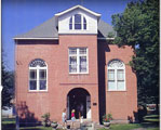
- Larimore City Hall: This historic building used to be the city hall. Now, it is home to a community museum.
- Larimore Dam: This is a fun outdoor area along a reservoir on the Turtle River. You can enjoy the beach, go fishing, camping, and swimming here.
- Myra Arboretum: An arboretum is a place where many different kinds of trees and plants are grown for study and display.
See also
 In Spanish: Larimore (Dakota del Norte) para niños
 | Aaron Henry |
 | T. R. M. Howard |
 | Jesse Jackson |


