
Steele County, North Dakota facts for kids
Quick facts for kids
Steele County
|
|
|---|---|

Steele County Courthouse in Finley
|
|

Location within the U.S. state of North Dakota
|
|
 North Dakota's location within the U.S. |
|
| Country | |
| State | |
| Founded | June 2, 1883 (created) July 13, 1883 (organized) |
| Named for | Edward H. Steele |
| Seat | Finley |
| Largest city | Finley |
| Area | |
| • Total | 715 sq mi (1,850 km2) |
| • Land | 712 sq mi (1,840 km2) |
| • Water | 3.2 sq mi (8 km2) 0.5% |
| Population
(2020)
|
|
| • Total | 1,798 |
| • Estimate
(2022)
|
1,788 |
| • Density | 2.5147/sq mi (0.9709/km2) |
| Time zone | UTC−6 (Central) |
| • Summer (DST) | UTC−5 (CDT) |
| Congressional district | At-large |
Steele County is a county in the state of North Dakota, USA. In 2020, about 1,798 people lived here. This makes it one of the smallest counties in North Dakota by population. The main town, or county seat, is Finley. Finley has been the county seat since 1919.
Contents
History of Steele County
The county was officially created on June 2, 1883. It was formed from parts of Griggs and Traill counties. At first, Steele County was not fully set up on its own. It was managed by Traill County for a short time.
The county was named after Edward H. Steele. He was a businessman who helped make the county happen. On July 13, 1883, Steele County became fully organized. It was no longer managed by Traill County. The town of Sherbrooke was chosen as the first county seat.
Later, in 1897, the town of Finley was started. Finley grew much bigger than Sherbrooke. Because of this, the county seat was moved to Finley in 1919. The borders of Steele County have stayed the same since it was created.
Geography and Nature
Steele County is located in North Dakota. The Sheyenne River flows near its western border. The Goose River flows through the northeastern part of the county.
The land here has gentle, rolling hills. You can also see many small lakes and ponds. Most of the land in Steele County is used for farming. The highest point in the county is about 1,562 feet (476 meters) above sea level. This spot is near the northwestern corner.
Steele County covers about 715 square miles (1,852 square kilometers). Most of this area, about 712 square miles (1,844 square kilometers), is land. The rest, about 3.2 square miles (8.3 square kilometers), is water.
Main Roads in Steele County
 North Dakota Highway 32
 North Dakota Highway 38
 North Dakota Highway 200
Neighboring Counties
Steele County shares borders with these other counties:
- Grand Forks County - to the north
- Traill County - to the east
- Cass County - to the southeast
- Barnes County - to the southwest
- Griggs County - to the west
- Nelson County - to the northwest
Lakes in Steele County
You can find several lakes in Steele County:
- Golden Lake
- Golden Rush Lake
- Lake Tobiason
- Lone Tree Lake
- North Golden Lake
- Stony Lake
- Willow Lake
People of Steele County
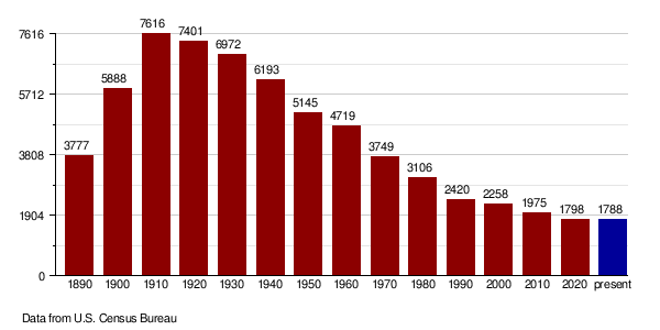
| Historical population | |||
|---|---|---|---|
| Census | Pop. | %± | |
| 1890 | 3,777 | — | |
| 1900 | 5,888 | 55.9% | |
| 1910 | 7,616 | 29.3% | |
| 1920 | 7,401 | −2.8% | |
| 1930 | 6,972 | −5.8% | |
| 1940 | 6,193 | −11.2% | |
| 1950 | 5,145 | −16.9% | |
| 1960 | 4,719 | −8.3% | |
| 1970 | 3,749 | −20.6% | |
| 1980 | 3,106 | −17.2% | |
| 1990 | 2,420 | −22.1% | |
| 2000 | 2,258 | −6.7% | |
| 2010 | 1,975 | −12.5% | |
| 2020 | 1,798 | −9.0% | |
| 2022 (est.) | 1,788 | −9.5% | |
| U.S. Decennial Census 1790-1960 1900-1990 1990-2000 2010-2020 |
|||
In 2020, the population of Steele County was 1,798 people.
Population Details (2010 Census)
In 2010, there were 1,975 people living in Steele County. There were 864 households, and 589 families. The county had about 2.8 people per square mile.
Most people in the county were white (97.6%). About 1.2% were American Indian. A small number were Black, Asian, or from other backgrounds. About 1.0% of the people were of Hispanic or Latino origin.
Many people in Steele County have Norwegian (60.0%) or German (35.2%) roots.
The average age of people in the county was 47.7 years old. About 4.2% of the population lived below the poverty line. This included 7.1% of those under 18 years old.
Population Changes Over Time
Towns and Communities
Cities in Steele County
Unincorporated Communities
These are smaller places that are not officially cities:
- Blabon
- Colgate
- Pickert
- Sherbrooke (The first county seat, now mostly empty)
Townships
Townships are smaller local government areas within the county.
- Beaver Creek
- Broadlawn
- Carpenter
- Colgate
- Easton
- Edendale
- Enger
- Finley
- Franklin
- Golden Lake
- Greenview
- Hugo
- Melrose
- Newburgh
- Primrose
- Riverside
- Sharon
- Sherbrooke
- Westfield
- Willow Lake
| Range 57 | Range 56 | Range 55 | Range 54 | |
|---|---|---|---|---|
| Township 148 | Sharon | Westfield | Beaver Creek | Newburgh |
| Township 147 | Franklin | Finley | Golden Lake | Enger |
| Township 146 | Greenview | Easton | Sherbrooke | Primrose |
| Township 145 | Riverside | Melrose | Hugo | Edendale |
| Township 144 | Willow Lake | Carpenter | Colgate | Broadlawn |
Schools in Steele County
Steele County has several school districts:
- Dakota Prairie Public School District 1
- Finley-Sharon Public School District 19
- Griggs County Central School District 18
- Hatton Public School District 7
- Hope-Page School District (This district was formed by combining Hope Public School District 10 and Page Public School District 80)
- May-Port CG Public School District 14
- Northwood Public School District 129
In 1964, there were 992 students in four schools in the county.
Images for kids
-
An old map of Steele County from 1911.

See also
 In Spanish: Condado de Steele (Dakota del Norte) para niños
