
Barnes County, North Dakota facts for kids
Quick facts for kids
Barnes County
|
|
|---|---|

Barnes County Courthouse
|
|

Location within the U.S. state of North Dakota
|
|
 North Dakota's location within the U.S. |
|
| Country | |
| State | |
| Founded | 1872 (created as Burbank) 1874 (renamed as Barnes) January 6, 1879 (organized) |
| Named for | judge Alanson H. Barnes |
| Seat | Valley City |
| Largest city | Valley City |
| Area | |
| • Total | 1,513 sq mi (3,920 km2) |
| • Land | 1,492 sq mi (3,860 km2) |
| • Water | 22 sq mi (60 km2) 1.4% |
| Population
(2020)
|
|
| • Total | 10,853 |
| • Estimate
(2023)
|
10,726 |
| • Density | 7.1732/sq mi (2.7696/km2) |
| Time zone | UTC−6 (Central) |
| • Summer (DST) | UTC−5 (CDT) |
| Congressional district | At-large |
Barnes County is a place in the state of North Dakota, United States. It is a type of area called a county. In 2020, about 10,853 people lived there. The main town and county seat is Valley City.
This county was first created in 1872. It was called Burbank County back then. It was named after Governor John A. Burbank. In 1874, its name was changed to Barnes County. This new name honored Alanson H. Barnes. He was a judge in the area at that time. The county officially started operating in Valley City on January 6, 1879.
Contents
Geography of Barnes County
The Sheyenne River flows through the middle of Barnes County. The land here has gentle, rolling hills. There are also many small lakes and ponds. Most of the land is used for farming. The highest point in the county is about 1,535 feet (468 meters) above sea level. Barnes County covers a total area of 1,513 square miles. About 1,492 square miles of this is land. The remaining 22 square miles is water.
Main Roads
 I-94
I-94 US 52
US 52 ND 1
ND 1 ND 9
ND 9 ND 18
ND 18 ND 26
ND 26 ND 32
ND 32 ND 46
ND 46
Bus Services
- Jefferson Lines
Neighboring Counties
- Griggs County – to the north
- Steele County – to the northeast
- Cass County – to the east
- Ransom County – to the southeast
- LaMoure County – to the southwest
- Stutsman County – to the west
Nature Areas
- Clausen Springs Recreation Area
- Clausen Springs State Game Management Area
- Hobart Lake National Wildlife Refuge
- Koldak State Game Management Area
- Riparian Restoration Interpretative Site
- Stoney Slough National Wildlife Refuge
- Tomahawk Lake National Wildlife Refuge
Lakes in Barnes County
- Lake Ashtabula
- Eckelson Lake
- Fox Lake
- Goose Lake
- Hobart Lake
- Island Lake
- Kee Lake
- Lake Benson
- Meadow Lake
- Moon Lake
- Mud Lake
- Round Lake
- Saint Marys Lake
- Sanborn Lake
- Tomahawk Lake
People of Barnes County
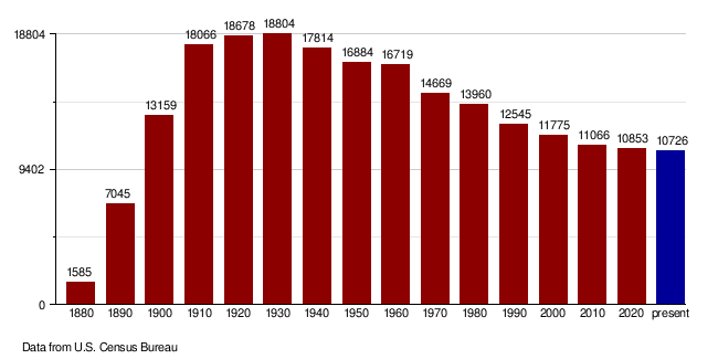
| Historical population | |||
|---|---|---|---|
| Census | Pop. | %± | |
| 1880 | 1,585 | — | |
| 1890 | 7,045 | 344.5% | |
| 1900 | 13,159 | 86.8% | |
| 1910 | 18,066 | 37.3% | |
| 1920 | 18,678 | 3.4% | |
| 1930 | 18,804 | 0.7% | |
| 1940 | 17,814 | −5.3% | |
| 1950 | 16,884 | −5.2% | |
| 1960 | 16,719 | −1.0% | |
| 1970 | 14,669 | −12.3% | |
| 1980 | 13,960 | −4.8% | |
| 1990 | 12,545 | −10.1% | |
| 2000 | 11,775 | −6.1% | |
| 2010 | 11,066 | −6.0% | |
| 2020 | 10,853 | −1.9% | |
| 2023 (est.) | 10,726 | −3.1% | |
| U.S. Decennial Census 1790-1960 1900-1990 1990-2000 2010-2020 |
|||
What the 2020 Census Shows
In 2020, the census counted 10,853 people in Barnes County. There were 4,772 households and 2,751 families. This means there were about 7.3 people per square mile. There were also 5,671 homes or housing units.
What the 2010 Census Showed
The 2010 census found 11,066 people living in the county. There were 4,826 households. About 7.4 people lived in each square mile. Most people (96.4%) were white. Other groups included Black or African American (0.8%) and American Indian (0.7%). Many people had roots from Germany (48.4%) or Norway (37.2%).
About 24.8% of households had kids under 18. Many households (50.8%) were married couples. The average household had 2.19 people. The average family had 2.79 people. The average age of people in the county was 44.3 years old.
The average yearly income for a household was $41,773. For families, it was $59,558.
Population Changes Over Time
Towns and Areas
Barnes County has several towns and smaller communities.
Cities in Barnes County
- Dazey
- Fingal
- Kathryn
- Leal
- Litchville
- Nome
- Oriska
- Pillsbury
- Rogers
- Sanborn
- Sibley
- Tower City (part of it)
- Valley City (the main town)
- Wimbledon
Smaller Communities (Unincorporated)
These places are not officially cities or towns.
Townships
Townships are smaller local government areas.
- Alta
- Anderson
- Ashtabula
- Baldwin
- Binghampton
- Brimer
- Cuba
- Dazey
- Eckelson
- Edna
- Ellsbury
- Getchell
- Grand Prairie
- Green
- Greenland
- Hemen
- Hobart
- Lake Town
- Mansfield
- Marsh
- Meadow Lake
- Minnie Lake
- Nelson
- Noltimier
- Norma
- Oakhill
- Oriska
- Pierce
- Potter
- Raritan
- Rogers
- Rosebud
- Sibley Trail
- Skandia
- Spring Creek
- Springvale
- Stewart
- Svea
- Thordenskjold
- Uxbridge
- Valley
- Weimer
Famous People from Barnes County
- Frank White – He was the eighth Governor of North Dakota. He also served as the Treasurer of the United States.
- Peggy Lee – A very famous singer and actress.
- Earl Pomeroy – He was a U.S. Congressman.
- Morley Nelson – A person who worked to protect nature.
Schools in Barnes County
Here are the school districts that serve Barnes County:
- Barnes County North Public School District 7
- Enderlin Area Public School District 24
- Griggs County Central School District 18
- Hope-Page School District
- Litchville-Marion Public School District 46
- Maple Valley Public School District 4
- Montpelier Public School District 14
- Valley City Public School District 2
Some school districts have joined together:
- Hope Public School District 10 – It joined with Page district in 2020.
- Oriska School District – It joined with Maple Valley in 2003.
- Page Public School District 80 – It joined with Hope district in 2020.
See also
 In Spanish: Condado de Barnes para niños
