
LaMoure County, North Dakota facts for kids
Quick facts for kids
LaMoure County
|
|
|---|---|

LaMoure County Courthouse in LaMoure
|
|

Location within the U.S. state of North Dakota
|
|
 North Dakota's location within the U.S. |
|
| Country | |
| State | |
| Founded | January 4, 1873 (created) October 27, 1881 (organized) |
| Named for | Judson LaMoure |
| Seat | LaMoure |
| Largest city | LaMoure |
| Area | |
| • Total | 1,151 sq mi (2,980 km2) |
| • Land | 1,146 sq mi (2,970 km2) |
| • Water | 4.9 sq mi (13 km2) 0.4% |
| Population
(2020)
|
|
| • Total | 4,093 |
| • Estimate
(2022)
|
4,098 |
| • Density | 3.5560/sq mi (1.3730/km2) |
| Time zone | UTC−6 (Central) |
| • Summer (DST) | UTC−5 (CDT) |
| Congressional district | At-large |
LaMoure County is a special area in North Dakota, a state in the United States. It's like a large district within the state. In 2020, about 4,093 people lived here. The main town, or county seat, is LaMoure.
Contents
History of LaMoure County
The idea for LaMoure County started on January 4, 1873. This was when the government of Dakota Territory decided to create it. At first, the main town was Grand Rapids.
However, the county wasn't fully set up right away. It was named after Judson LaMoure. He was an important person in the government from 1872 to 1918.
LaMoure County officially began on October 27, 1881. Its borders changed a couple of times after that. But they have stayed the same since March 1883. The current main town, LaMoure, was founded in 1882. Soon after, it became the county seat.

Geography and Nature in LaMoure County
The James River flows through the middle of LaMoure County. Another river, the South Branch Maple River, also starts here. The land in the county has rolling hills. Most of it is used for farming.
The land slopes down towards the south and east. The highest point is about 2,047 feet (624 meters) above sea level. This is on the western edge of the county. LaMoure County covers a total area of 1,151 square miles (2,981 square kilometers). Most of this is land, with a small part being water.
Did you know LaMoure County has a special Navy station? It's called the Naval Radio Transmitter Facility LaMoure. This station helps send radio signals for the Navy.
Main Roads in LaMoure County
 U.S. Highway 281
 North Dakota Highway 1
 North Dakota Highway 13
 North Dakota Highway 46
 North Dakota Highway 56
Local Airports
- Kulm Municipal Airport (FAA LID: D03) - This is a public airport near the town of Kulm.
Neighboring Counties
- Stutsman County - north
- Barnes County - northeast
- Ransom County - east
- Dickey County - south
- McIntosh County - southwest
- Logan County - west
Protected Natural Areas
- Bone Hill National Wildlife Refuge - This is a special place that protects wildlife.
Lakes in LaMoure County
- Bone Hill Creek Lake
- Cottonwood Lake
- Lake Lamoure
- Pearl Lake
- Wild Rice Slough
People of LaMoure County
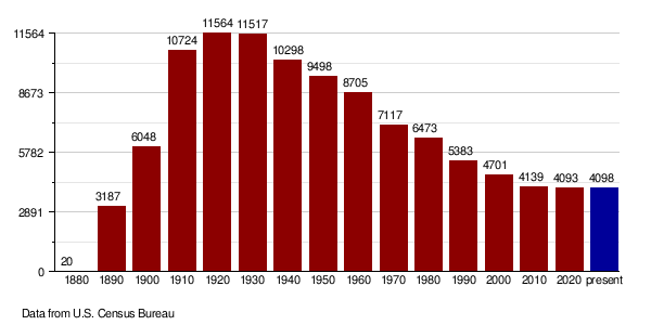
The number of people living in LaMoure County has changed over time. Here's a look at the population from past years:
| Historical population | |||
|---|---|---|---|
| Census | Pop. | %± | |
| 1880 | 20 | — | |
| 1890 | 3,187 | 15,835.0% | |
| 1900 | 6,048 | 89.8% | |
| 1910 | 10,724 | 77.3% | |
| 1920 | 11,564 | 7.8% | |
| 1930 | 11,517 | −0.4% | |
| 1940 | 10,298 | −10.6% | |
| 1950 | 9,498 | −7.8% | |
| 1960 | 8,705 | −8.3% | |
| 1970 | 7,117 | −18.2% | |
| 1980 | 6,473 | −9.0% | |
| 1990 | 5,383 | −16.8% | |
| 2000 | 4,701 | −12.7% | |
| 2010 | 4,139 | −12.0% | |
| 2020 | 4,093 | −1.1% | |
| 2022 (est.) | 4,098 | −1.0% | |
| U.S. Decennial Census 1790-1960 1900-1990 1990-2000 2010-2020 |
|||
Population in 2020
In 2020, the census counted 4,093 people living in LaMoure County.
Population in 2010
In 2010, there were 4,139 people living here. There were 1,825 households, which are groups of people living together. The average age of people in the county was about 49 years old.
Population Changes Over Time
This chart shows how the population of LaMoure County has changed through the years. You can see how it grew and then slowly decreased.
Towns and Communities
LaMoure County has several towns and smaller communities.
Cities in LaMoure County
Smaller Communities
These are places where people live, but they are not officially called cities.
- Alfred
- Diesem
- Medberry
- Nortonville
Townships in LaMoure County
Townships are smaller local government areas within the county.
- Adrian
- Badger
- Black Loam
- Bluebird
- Dean
- Gladstone
- Glen
- Glenmore
- Golden Glen
- Grand Rapids
- Grandview
- Greenville
- Henrietta
- Kennison
- Mikkelson
- Nora
- Norden
- Ovid
- Pearl Lake
- Pomona View
- Prairie
- Raney
- Ray
- Roscoe
- Russell
- Ryan
- Saratoga
- Sheridan
- Swede
- Wano
- Willowbank
Ghost Town
- Alfred - This was once a community, but now it's a ghost town, meaning most people have left.
Two ships in the United States Navy have been named after LaMoure County! These were special ships called tank landing ships. They were used to carry soldiers and equipment to shore during wars.
- The first ship, USS La Moure County (LST-883), started serving on January 23, 1945. It was used until December 7, 1959.
- The second ship, USS La Moure County (LST-1194), began its service on December 1, 1971. It was active until November 17, 2000.
See also
 In Spanish: Condado de LaMoure para niños
