
Logan County, North Dakota facts for kids
Quick facts for kids
Logan County
|
|
|---|---|

Winter view of downtown Napoleon, North Dakota.
|
|

Location within the U.S. state of North Dakota
|
|
 North Dakota's location within the U.S. |
|
| Country | |
| State | |
| Founded | January 4, 1873 (created) September 1, 1884 (organized) |
| Named for | John A. Logan |
| Seat | Napoleon |
| Largest city | Napoleon |
| Area | |
| • Total | 1,011 sq mi (2,620 km2) |
| • Land | 993 sq mi (2,570 km2) |
| • Water | 18 sq mi (50 km2) 1.8% |
| Population
(2020)
|
|
| • Total | 1,876 |
| • Estimate
(2022)
|
1,855 |
| • Density | 1.8556/sq mi (0.7164/km2) |
| Time zone | UTC−6 (Central) |
| • Summer (DST) | UTC−5 (CDT) |
| Congressional district | At-large |
Logan County is a place in North Dakota, a state in the United States. It's called a county, which is like a smaller area within a state. In 2020, about 1,876 people lived there. The main town, or county seat, of Logan County is Napoleon.
Contents
History of Logan County
Logan County was officially created on January 4, 1873. This happened when the government of the Dakota Territory decided to set up new areas. The county was named after John A. Logan. He was a famous general during the American Civil War and later became a United States Senator from Illinois.
Even though the county was created in 1873, its local government didn't start working right away. The county government officially began on September 1, 1884. This meant it could then manage its own affairs.
The borders of Logan County changed a bit in 1883. Since then, the county has kept the same shape and size. The town of Napoleon was the county seat from 1884 to 1899. For a short time in 1899, another town called King became the county seat. But soon after, Napoleon was chosen again and has been the county seat ever since.
Geography and Nature
Logan County has rolling hills and many small lakes and ponds. Most of the land is used for farming. The land gently slopes downwards towards the east. The highest point in the county is in the southwest. It is about 2,133 feet (650 meters) above sea level.
The county covers a total area of 1,011 square miles (2,618 square kilometers). Out of this, 993 square miles (2,572 square kilometers) is land. The remaining 18 square miles (47 square kilometers) is water, mostly from its lakes and ponds.
Main Roads in Logan County
 North Dakota Highway 3
 North Dakota Highway 13
 North Dakota Highway 30
 North Dakota Highway 34
 North Dakota Highway 56
Neighboring Counties
Logan County shares its borders with several other counties:
- Stutsman County - to the northeast
- LaMoure County - to the east
- McIntosh County - to the south
- Emmons County - to the west
- Kidder County - to the northwest
Lakes and Protected Areas
Logan County is home to several beautiful lakes:
- Arnies Lake
- Beaver Lake
- Doyles Lake
- Fish Lake (part)
- Island Lake
- McKenna Lake
- Red Lake
- Round Lake
There is also a special area called Beaver Lake State Park. This park helps protect nature and offers outdoor activities.
People of Logan County
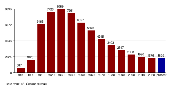
The number of people living in Logan County has changed over the years. Here's a look at the population from different census counts:
| Historical population | |||
|---|---|---|---|
| Census | Pop. | %± | |
| 1890 | 597 | — | |
| 1900 | 1,625 | 172.2% | |
| 1910 | 6,168 | 279.6% | |
| 1920 | 7,723 | 25.2% | |
| 1930 | 8,089 | 4.7% | |
| 1940 | 7,561 | −6.5% | |
| 1950 | 6,357 | −15.9% | |
| 1960 | 5,369 | −15.5% | |
| 1970 | 4,245 | −20.9% | |
| 1980 | 3,493 | −17.7% | |
| 1990 | 2,847 | −18.5% | |
| 2000 | 2,308 | −18.9% | |
| 2010 | 1,990 | −13.8% | |
| 2020 | 1,876 | −5.7% | |
| 2022 (est.) | 1,855 | −6.8% | |
| U.S. Decennial Census 1790-1960 1900-1990 1990-2000 2010-2020 |
|||
Population in 2020
According to the census taken in 2020, there were 1,876 people living in Logan County.
Population in 2010
In 2010, the census showed there were 1,990 people in the county. Most people were white (98.4%). A small number were American Indian, Asian, or Black. About 0.6% of the population was of Hispanic or Latino background.
Many people in Logan County have German roots (76.0%). A good number also have Russian (16.2%) or Norwegian (9.9%) family backgrounds. Logan County actually has the highest percentage of people with Russian-American heritage in the entire United States!
How the Population Changed Over Time
This chart shows how the number of people living in Logan County has changed over many years.
Towns and Areas
Logan County has several towns and other communities.
Cities in Logan County
- Fredonia
- Gackle
- Lehr (partly in McIntosh County)
- Napoleon (the main county seat)
Small Unincorporated Communities
These are smaller places that don't have their own city government:
- Burnstad
- Guyson
Townships in Logan County
Townships are smaller local government areas within the county:
- Finn
- Glendale
- Gutschmidt
- Haag
- Janke
- Red Lake
- Sealy
Unorganized Territories
These are areas that are not part of a township:
- East Logan
- West Logan
Townships That No Longer Exist
Some townships that used to be in Logan County are now part of other areas:
- Bryant (now in West Logan UT)
- Dixon (now in West Logan UT)
- Kroeber
- Starkey (now in West Logan UT)
Images for kids
-
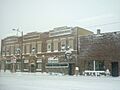
Winter view of downtown Napoleon, North Dakota.
See also
 In Spanish: Condado de Logan (Dakota del Norte) para niños
