
Kidder County, North Dakota facts for kids
Quick facts for kids
Kidder County
|
|
|---|---|

The Kidder County Courthouse in Steele
|
|

Location within the U.S. state of North Dakota
|
|
 North Dakota's location within the U.S. |
|
| Country | |
| State | |
| Founded | January 4, 1873 (created) March 22, 1881 (organized) |
| Named for | Jefferson Kidder |
| Seat | Steele |
| Largest city | Steele |
| Area | |
| • Total | 1,433 sq mi (3,710 km2) |
| • Land | 1,351 sq mi (3,500 km2) |
| • Water | 82 sq mi (210 km2) 5.7% |
| Population
(2020)
|
|
| • Total | 2,394 |
| • Estimate
(2022)
|
2,393 |
| • Density | 1.6706/sq mi (0.6450/km2) |
| Time zone | UTC−6 (Central) |
| • Summer (DST) | UTC−5 (CDT) |
| Congressional district | At-large |
Kidder County is a county located in the state of North Dakota. As of the 2020 census, about 2,394 people lived there. The main town and county seat (where the county government is) is Steele.
Contents
History of Kidder County
The area that is now Kidder County was first created on January 4, 1873. This was done by the lawmakers of the Dakota Territory. At first, there wasn't an official county government.
The county is named after Jefferson Parrish Kidder. He was an important person who represented the Dakota Territory in the United States Congress. He also served as a judge in the territory's highest court. The county government officially started on March 22, 1881.
The borders of Kidder County changed a couple of times. They were adjusted in 1879 and again in 1885. Since 1885, the county's borders have stayed the same.

Geography and Nature
Kidder County's land is mostly rolling hills with many lakes and ponds. Most of the land is used for farming. The land slopes down towards the east and south. The highest point in the county is a hill in the northwest. It is about 2,064 feet (629 meters) above sea level.
The county covers a total area of about 1,433 square miles (3,711 square kilometers). Of this, 1,351 square miles (3,499 square kilometers) is land. The remaining 82 square miles (212 square kilometers) is water, making up about 5.7% of the total area.
Main Roads
 I-94
I-94 ND 3
ND 3 ND 36
ND 36
Lakes in Kidder County
Kidder County is home to many lakes and bodies of water. Some of them include:
- Alkali Lake
- Alkaline Lake
- Ashley Lake
- Big Muddy Lake
- Bird Lake
- Buffalo Lake
- Cherry Lake
- Dead Buffalo Lake
- Deer Lake
- Fresh Lake
- Geneva Lake
- Harker Lake
- Horsehead Lake
- Kunkel Lake
- Lake Etta
- Lake George
- Lake Helen
- Lake Henry
- Lake Isabel
- Long Alkaline Lake
- Long Lake (partial)
- McPhall Slough
- Mud Lake
- Pursian Lake
- Round Lake
- Salt Alkaline Lake
- Sibley Lake
- Swan Lake
- Upper Harker Lake
- Willow Lake
- Woodhouse Lake
Neighboring Counties
Kidder County shares its borders with several other counties:
- Wells County - north
- Stutsman County - east
- Logan County - south
- Emmons County - southwest
- Burleigh County - west
- Sheridan County - northwest
Protected Natural Areas
Several areas in Kidder County are protected to preserve nature and wildlife. These include:
- Alkaline Lake State Wildlife Management Area
- Dawson State Game Management Area
- Hutchinson Lake National Wildlife Refuge
- Lake George National Wildlife Refuge
- Lake Williams State Game Management Area
- Long Lake National Wildlife Refuge (part)
- Slade National Wildlife Refuge
- Streeter Memorial State Park
People of Kidder County
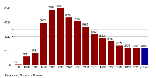
The population of Kidder County has changed over the years. Here's how it has grown and shrunk:
| Historical population | |||
|---|---|---|---|
| Census | Pop. | %± | |
| 1880 | 89 | — | |
| 1890 | 1,211 | 1,260.7% | |
| 1900 | 1,754 | 44.8% | |
| 1910 | 5,962 | 239.9% | |
| 1920 | 7,798 | 30.8% | |
| 1930 | 8,031 | 3.0% | |
| 1940 | 6,692 | −16.7% | |
| 1950 | 6,168 | −7.8% | |
| 1960 | 5,386 | −12.7% | |
| 1970 | 4,362 | −19.0% | |
| 1980 | 3,833 | −12.1% | |
| 1990 | 3,332 | −13.1% | |
| 2000 | 2,753 | −17.4% | |
| 2010 | 2,435 | −11.6% | |
| 2020 | 2,394 | −1.7% | |
| 2022 (est.) | 2,393 | −1.7% | |
| U.S. Decennial Census 1790-1960 1900-1990 1990-2000 2010-2020 |
|||
Population in 2020
According to the census from 2020, there were 2,394 people living in Kidder County.
Population in 2010
In the 2010 census, there were 2,435 people. Most people in the county were white (96.3%). Some of the main backgrounds of the people living there included German (65.8%) and Norwegian (21.8%).
The average age of people in the county was about 47.2 years old.
Population Changes Over Time
This chart shows how the number of people living in Kidder County has changed over many years:
Towns and Areas
Kidder County has several towns and other communities.
Cities
Unincorporated Communities
These are smaller communities that are not officially organized as cities:
Townships
Townships are smaller local government areas within the county:
- Allen
- Atwood
- Baker
- Buckeye
- Bunker
- Chestina
- Clear Lake
- Crown Hill
- Crystal Springs
- Excelsior
- Frettim
- Graf
- Haynes
- Lake Williams
- North & South Manning
- North & South Merkel
- Northwest
- Peace
- Petersville
- Pettibone
- Pleasant Hill
- Quinby
- Rexine
- Robinson
- Sibley
- Stewart
- Tanner
- Tappen
- Tuttle
- Valley
- Vernon
- Wallace
- Weiser
- Westford
- Williams
- Woodlawn
Unorganized Territories
These are areas that do not have their own township government:
- Kickapoo
- Liberty
See also
 In Spanish: Condado de Kidder (Dakota del Norte) para niños
