
Stutsman County, North Dakota facts for kids
Quick facts for kids
Stutsman County
|
|
|---|---|

Historic Stutsman County Courthouse
|
|

Location within the U.S. state of North Dakota
|
|
 North Dakota's location within the U.S. |
|
| Country | |
| State | |
| Founded | January 4, 1873 (created) June 10, 1873 (organized) |
| Named for | Enos Stutsman |
| Seat | Jamestown |
| Largest city | Jamestown |
| Area | |
| • Total | 2,298 sq mi (5,950 km2) |
| • Land | 2,222 sq mi (5,750 km2) |
| • Water | 76 sq mi (200 km2) 3.3% |
| Population
(2020)
|
|
| • Total | 21,593 |
| • Estimate
(2023)
|
21,392 |
| • Density | 9.3964/sq mi (3.6280/km2) |
| Time zone | UTC−6 (Central) |
| • Summer (DST) | UTC−5 (CDT) |
| Congressional district | At-large |
Stutsman County is a special area in the state of North Dakota in the United States. It's like a big neighborhood with its own government. As of 2020, about 21,593 people lived here. This makes it the 8th most populated county in North Dakota. The main town and where the county government is located is Jamestown.
The entire Stutsman County area is also part of something called the Jamestown, North Dakota Micropolitan Statistical Area. This just means it's a smaller city area that's connected to nearby communities.
Contents
History of Stutsman County
Stutsman County was officially created on January 4, 1873. This happened when the government of the Dakota Territory decided to set aside this land. They took parts from two other counties, Buffalo and Pembina, to form it.
The county was named after Enos Stutsman. He was a lawyer and a politician who was important in the area at that time. A few months later, on June 10, 1873, the county officially started its own government. Jamestown was chosen as the county seat right away. The borders of Stutsman County have stayed the same ever since it was created.

What is Stutsman County Like?
Stutsman County is a place with gently rolling hills. You'll find many lakes and ponds, especially in the western part. Most of the land is used for farming. The James River flows through the eastern-central part of the county, heading south.
The land generally slopes downwards towards the east and south. The highest point in the county is a hill in the southwestern corner. It's about 1,965 feet (599 meters) above sea level. Stutsman County covers a total area of about 2,298 square miles (5,952 square kilometers). Most of this is land (2,222 square miles or 5,755 square kilometers), and about 76 square miles (197 square kilometers) is water. This makes it one of the largest counties in North Dakota.
Neighboring Counties
Stutsman County shares its borders with several other counties:
- Foster County to the north
- Griggs County to the northeast
- Barnes County to the east
- LaMoure County to the southeast
- Logan County to the southwest
- Kidder County to the west
- Wells County to the northwest
Special Natural Areas
Stutsman County is home to some important protected natural areas. These places help protect wildlife and their homes.
- Arrowwood National Wildlife Refuge (part of it)
- Chase Lake National Wildlife Refuge
- Halfway Lake National Wildlife Refuge
- National Audubon Society Alkali Lake Wildlife Refuge
Lakes in the County
There are many lakes and water bodies in Stutsman County. Some of the notable ones include:
- Alkali Lake
- Arrowwood Lake
- Barnes Lake
- Chase Lake
- Jamestown Reservoir
- Jim Lake
- Moon Lake
- Pearl Lake
- Prairie Lake
- Spiritwood Lake
Who Lives in Stutsman County?
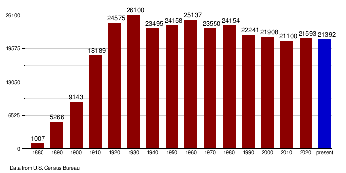
| Historical population | |||
|---|---|---|---|
| Census | Pop. | %± | |
| 1880 | 1,007 | — | |
| 1890 | 5,266 | 422.9% | |
| 1900 | 9,143 | 73.6% | |
| 1910 | 18,189 | 98.9% | |
| 1920 | 24,575 | 35.1% | |
| 1930 | 26,100 | 6.2% | |
| 1940 | 23,495 | −10.0% | |
| 1950 | 24,158 | 2.8% | |
| 1960 | 25,137 | 4.1% | |
| 1970 | 23,550 | −6.3% | |
| 1980 | 24,154 | 2.6% | |
| 1990 | 22,241 | −7.9% | |
| 2000 | 21,908 | −1.5% | |
| 2010 | 21,100 | −3.7% | |
| 2020 | 21,593 | 2.3% | |
| 2023 (est.) | 21,392 | 1.4% | |
| U.S. Decennial Census 1790-1960 1900-1990 1990-2000 2010-2020 |
|||
The population of Stutsman County changes over time. In 2020, there were 21,593 people living here. The county has about 9.7 people per square mile. There were over 10,000 homes in the county.
Back in 2010, there were 21,100 people. Most people were white (95.6%). There were also people who identified as American Indian, Black or African American, Asian, and other races. About 1.7% of the population was of Hispanic or Latino background. Many families in the county have German and Norwegian roots.
How the Population Has Changed
The chart below shows how the number of people living in Stutsman County has changed over many years, from 1880 up to today. You can see how the population grew and changed with each decade.
Towns and Communities
Stutsman County has several towns and communities where people live.
Cities in Stutsman County
- Buchanan
- Cleveland
- Courtenay
- Jamestown (This is the main city and where the county government is)
- Kensal
- Medina
- Montpelier
- Pingree
- Spiritwood Lake
- Streeter
- Woodworth
Other Populated Areas
- Spiritwood (a census-designated place)
- Ypsilanti (a census-designated place)
Small Unincorporated Communities
These are smaller places that don't have their own city government.
- Bloom
- Clementsville
- Durupt
- Fried
- Kloze
- Millarton
- Sharlow
- Sydney
- Vashti
Images for kids
-
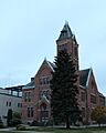
Historic Stutsman County Courthouse
See also
 In Spanish: Condado de Stutsman para niños
