
Sheridan County, North Dakota facts for kids
Quick facts for kids
Sheridan County
|
|
|---|---|

Sheridan County Courthouse (McClusky, North Dakota)
|
|

Location within the U.S. state of North Dakota
|
|
 North Dakota's location within the U.S. |
|
| Country | |
| State | |
| Founded | January 4, 1873 (created) December 24, 1908 (organized) |
| Named for | Philip Henry Sheridan |
| Seat | McClusky |
| Largest city | McClusky |
| Area | |
| • Total | 1,006 sq mi (2,610 km2) |
| • Land | 972 sq mi (2,520 km2) |
| • Water | 33 sq mi (90 km2) 3.3% |
| Population
(2020)
|
|
| • Total | 1,265 |
| • Estimate
(2022)
|
1,295 |
| • Density | 1.2575/sq mi (0.4855/km2) |
| Time zone | UTC−6 (Central) |
| • Summer (DST) | UTC−5 (CDT) |
| Congressional district | At-large |
Sheridan County is a county located in the U.S. state of North Dakota. It's named after Civil War General Philip Henry Sheridan. As of the 2020 census, about 1,265 people lived there. This makes it the third-least populated county in North Dakota. The main town and county seat is McClusky.
Contents
History of Sheridan County
The area that is now Sheridan County was first set up as a county on January 4, 1873. This was done by the government of the Dakota Territory. It was named after General Philip Henry Sheridan. However, the county didn't fully start its own government at that time.
Over the years, the county's borders changed a few times. In 1892, Sheridan County was actually closed down. Its land became part of McLean County. But this didn't last long! On November 3, 1908, people in McLean County voted to create a new county from its eastern part. This new county was Sheridan County again, though its borders were a bit different. The new county government officially started on December 24, 1908.
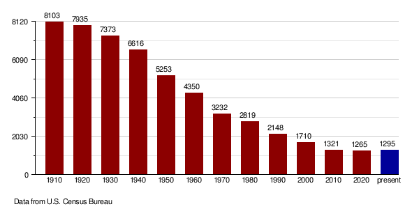
Sheridan County has seen a big drop in its population over many years. For example, in 1930, over 7,300 people lived there. By 2010, that number had fallen to about 1,300. This big decrease in people moving away is called "out-migration." It's been the highest population drop among all counties in North Dakota.

Geography of Sheridan County
Sheridan County has rolling hills that are often dry. You can also find many lakes and ponds scattered around. Most of the land is used for farming. The land gently slopes down towards the north and east. The highest point in the county is about 2,034 feet (620 meters) above sea level. This spot is on the eastern part of its southern border.
The county covers a total area of about 1,006 square miles (2,606 square kilometers). Out of this, 972 square miles (2,517 square kilometers) is land. The remaining 33 square miles (85 square kilometers) is water, which is about 3.3% of the total area.
Major Roads in Sheridan County
 U.S. Highway 52
 North Dakota Highway 14
 North Dakota Highway 53
 North Dakota Highway 200
Counties Next to Sheridan County
- McHenry County - north
- Pierce County - northeast
- Wells County - east
- Kidder County - southeast
- Burleigh County - south
- McLean County - west
Protected Natural Areas
- Sheyenne Lake National Wildlife Refuge is a special area set aside to protect wildlife.
Lakes in Sheridan County
- Bentz Lake
- Cherry Lake
- Coal Mine Lake
- Ebel Lake
- Guyes Lake
- Heckers Lake
- Kandt Lake
- Krueger Lake
- Lake Richard (part)
- Lone Tree Lake
- Moesner Lake
- Pelican Lake (part)
- Postel Lake
- Salt Lake (part)
- Sand Lake
- Sheyenne Lake
Population and People
| Historical population | |||
|---|---|---|---|
| Census | Pop. | %± | |
| 1910 | 8,103 | — | |
| 1920 | 7,935 | −2.1% | |
| 1930 | 7,373 | −7.1% | |
| 1940 | 6,616 | −10.3% | |
| 1950 | 5,253 | −20.6% | |
| 1960 | 4,350 | −17.2% | |
| 1970 | 3,232 | −25.7% | |
| 1980 | 2,819 | −12.8% | |
| 1990 | 2,148 | −23.8% | |
| 2000 | 1,710 | −20.4% | |
| 2010 | 1,321 | −22.7% | |
| 2020 | 1,265 | −4.2% | |
| 2022 (est.) | 1,295 | −2.0% | |
| U.S. Decennial Census 1790-1960 1900-1990 1990-2000 2010-2020 |
|||
Every ten years, the United States counts its population in a process called a census. This helps us understand how many people live in different areas.
2020 Census Information
According to the 2020 census, there were 1,265 people living in Sheridan County.
Here's a look at the different groups of people:
- Most people, about 1,191, were White and not Hispanic or Latino.
- There were 11 American Indian and Alaska Native people.
- 8 Asian people lived in the county.
- 2 Black or African American people lived there.
- 10 people were Hispanic or Latino.
- 5 people were of Some Other Race.
- 48 people were of Two or More Races.
When looking at families and homes:
- The average family size in Sheridan County was about 2.63 people.
- About 48.1% of homes were married-couple families.
- About 20.2% were male householders without a spouse.
- About 27.3% were female householders without a spouse.
2010 Census Information
In 2010, the census counted 1,321 people in Sheridan County. There were 645 households (groups of people living together) and 417 families. On average, there were about 1.36 people per square mile.
Most people in the county were white (96.7%). Other groups included American Indian (1.1%), Black or African American (0.3%), Pacific Islander (0.2%), and Asian (0.2%). About 1.2% of the population was Hispanic or Latino.
Many people in Sheridan County have German roots (70.1%). Other common backgrounds include Norwegian (14.2%), English (6.3%), and Russian (6.0%).
In 2010, about 17.5% of households had children under 18 living with them. The average household had 2.05 people, and the average family had 2.55 people. The average age of people in the county was 53.4 years old.
Population Changes Over Time
This chart shows how the population of Sheridan County has changed over the years, based on the U.S. Census.
Towns and Areas in Sheridan County
Sheridan County has several communities, including cities, a census-designated place, and unincorporated areas.
Cities in Sheridan County
Census-Designated Place
- Denhoff is a place that the census bureau defines for statistical purposes.
Unincorporated Communities
These are smaller communities that are not officially organized as cities or towns.
- Lincoln Valley
- Pickardville
Townships in Sheridan County
Townships are smaller local government areas within the county.
- Berlin
- Boone
- Denhoff
- Edgemont
- Fairview
- Goodrich
- Highland
- Lincoln Dale
- Martin
- Mauch
- McClusky
- Pickard
- Prophets
- Rosenfield
See also
 In Spanish: Condado de Sheridan (Dakota del Norte) para niños
