McClusky, North Dakota facts for kids
Quick facts for kids
McClusky, North Dakota
|
|
|---|---|

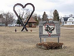
Sign and sculpture entering McClusky on Highway 200
|
|

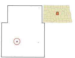
Location of McClusky, North Dakota
|
|
| Country | United States |
| State | North Dakota |
| County | Sheridan |
| Founded | 1905 |
| Area | |
| • Total | 0.37 sq mi (0.96 km2) |
| • Land | 0.37 sq mi (0.96 km2) |
| • Water | 0.00 sq mi (0.00 km2) |
| Elevation | 1,936 ft (590 m) |
| Population
(2020)
|
|
| • Total | 322 |
| • Estimate
(2022)
|
326 |
| • Density | 867.92/sq mi (334.80/km2) |
| Time zone | UTC-6 (Central (CST)) |
| • Summer (DST) | UTC-5 (CDT) |
| ZIP code |
58463
|
| Area code(s) | 701 |
| FIPS code | 38-49020 |
| GNIS feature ID | 1036141 |
McClusky is a small city in Sheridan County, North Dakota, United States. It is the main town and the county seat of Sheridan County. In 2020, about 322 people lived there. McClusky was started in 1905. It is special because it's the closest town to the exact middle of North Dakota. This spot is about five miles southwest of the city.
Contents
History of McClusky
McClusky was officially laid out in 1905. This happened when the railroad tracks were built to reach that area. The city got its name from William Henderson McClusky, who was one of the first people to settle there. A post office, where people send and receive mail, has been open in McClusky since 1903. The Sheridan County Courthouse, an important government building, was built in 1938.
Getting Around McClusky
In the past, the Red River Valley and Western Railroad had train tracks that went through McClusky. These tracks went even further west. However, the train line was officially closed in 2000. Today, North Dakota Highway 200 runs right through the center of town. This highway is very popular with cyclists who are riding across the country. For small planes, there is also the McClusky Municipal Airport.
McClusky's Location
McClusky covers a total area of about 0.39 square miles (0.96 square kilometers). All of this area is land. There are no large bodies of water within the city limits. McClusky is often called the "heart" of North Dakota. This is because it is very close to the geographical center of the state.
People of McClusky
| Historical population | |||
|---|---|---|---|
| Census | Pop. | %± | |
| 1910 | 517 | — | |
| 1920 | 646 | 25.0% | |
| 1930 | 719 | 11.3% | |
| 1940 | 924 | 28.5% | |
| 1950 | 850 | −8.0% | |
| 1960 | 751 | −11.6% | |
| 1970 | 664 | −11.6% | |
| 1980 | 658 | −0.9% | |
| 1990 | 492 | −25.2% | |
| 2000 | 415 | −15.7% | |
| 2010 | 380 | −8.4% | |
| 2020 | 322 | −15.3% | |
| 2022 (est.) | 326 | −14.2% | |
| U.S. Decennial Census 2020 Census |
|||
Population in 2010
According to the census from 2010, there were 380 people living in McClusky. These people lived in 206 different homes. About half of these homes (103) were families. The city had about 974 people per square mile. Most of the people living in McClusky were White (91.8%). There were also smaller groups of Native American (2.9%) and African American (0.5%) residents.
Many homes (47.6%) had just one person living in them. About 27.7% of all homes had someone aged 65 or older living alone. The average age of people in McClusky was 54 years old. About 17.1% of residents were under 18. Also, a large number of people (37.1%) were 65 years or older. More women lived in McClusky than men, with 55.5% being female and 44.5% male.
Schools in McClusky
The local school district for students in McClusky is called the McClusky School District.
Famous People from McClusky
- John E. Davis was once the mayor of McClusky. He later became the 25th Governor of North Dakota.
McClusky's Weather
McClusky has a type of weather called a humid continental climate. This means it has big changes in temperature during the year. Summers are warm to hot, and sometimes humid. Winters are cold, and can be very cold.
| Climate data for McClusky, North Dakota (1991–2020 normals, extremes 1922–present) | |||||||||||||
|---|---|---|---|---|---|---|---|---|---|---|---|---|---|
| Month | Jan | Feb | Mar | Apr | May | Jun | Jul | Aug | Sep | Oct | Nov | Dec | Year |
| Record high °F (°C) | 59 (15) |
65 (18) |
81 (27) |
95 (35) |
105 (41) |
105 (41) |
115 (46) |
105 (41) |
106 (41) |
93 (34) |
76 (24) |
62 (17) |
115 (46) |
| Mean daily maximum °F (°C) | 23.0 (−5.0) |
27.3 (−2.6) |
40.4 (4.7) |
57.0 (13.9) |
70.6 (21.4) |
79.4 (26.3) |
85.3 (29.6) |
85.2 (29.6) |
75.3 (24.1) |
58.3 (14.6) |
40.4 (4.7) |
27.2 (−2.7) |
55.8 (13.2) |
| Daily mean °F (°C) | 13.0 (−10.6) |
16.8 (−8.4) |
29.2 (−1.6) |
44.3 (6.8) |
57.3 (14.1) |
66.9 (19.4) |
72.3 (22.4) |
71.2 (21.8) |
61.6 (16.4) |
46.3 (7.9) |
30.4 (−0.9) |
17.8 (−7.9) |
43.9 (6.6) |
| Mean daily minimum °F (°C) | 3.0 (−16.1) |
6.3 (−14.3) |
18.0 (−7.8) |
31.7 (−0.2) |
44.0 (6.7) |
54.4 (12.4) |
59.4 (15.2) |
57.1 (13.9) |
47.8 (8.8) |
34.4 (1.3) |
20.4 (−6.4) |
8.5 (−13.1) |
32.1 (0.1) |
| Record low °F (°C) | −38 (−39) |
−53 (−47) |
−33 (−36) |
−10 (−23) |
9 (−13) |
26 (−3) |
30 (−1) |
26 (−3) |
7 (−14) |
−6 (−21) |
−23 (−31) |
−36 (−38) |
−53 (−47) |
| Average precipitation inches (mm) | 0.49 (12) |
0.45 (11) |
0.67 (17) |
1.23 (31) |
2.48 (63) |
3.36 (85) |
2.53 (64) |
2.30 (58) |
1.91 (49) |
1.39 (35) |
0.69 (18) |
0.67 (17) |
18.17 (462) |
| Average snowfall inches (cm) | 7.8 (20) |
5.6 (14) |
5.9 (15) |
4.4 (11) |
0.4 (1.0) |
0.0 (0.0) |
0.0 (0.0) |
0.0 (0.0) |
0.0 (0.0) |
2.8 (7.1) |
8.8 (22) |
9.3 (24) |
45.0 (114) |
| Average precipitation days (≥ 0.01 in) | 5.2 | 4.7 | 4.9 | 5.5 | 9.2 | 10.3 | 8.6 | 6.8 | 6.6 | 6.5 | 5.5 | 5.6 | 79.4 |
| Average snowy days (≥ 0.1 in) | 4.8 | 3.7 | 2.5 | 1.1 | 0.2 | 0.0 | 0.0 | 0.0 | 0.0 | 1.1 | 3.7 | 4.7 | 21.8 |
| Source: NOAA | |||||||||||||
See also
 In Spanish: McClusky (Dakota del Norte) para niños
 | Kyle Baker |
 | Joseph Yoakum |
 | Laura Wheeler Waring |
 | Henry Ossawa Tanner |

