
McLean County, North Dakota facts for kids
Quick facts for kids
McLean County
|
|
|---|---|

Historic McLean County Courthouse, now Historical Museum.
|
|

Location within the U.S. state of North Dakota
|
|
 North Dakota's location within the U.S. |
|
| Country | |
| State | |
| Founded | March 8, 1883 (created) November 1, 1883 (organized) |
| Named for | John A. McLean |
| Seat | Washburn |
| Largest city | Garrison |
| Area | |
| • Total | 2,328 sq mi (6,030 km2) |
| • Land | 2,111 sq mi (5,470 km2) |
| • Water | 217 sq mi (560 km2) 9.3% |
| Population
(2020)
|
|
| • Total | 9,771 |
| • Estimate
(2023)
|
9,832 |
| • Density | 4.1972/sq mi (1.6205/km2) |
| Time zone | UTC−6 (Central) |
| • Summer (DST) | UTC−5 (CDT) |
| Congressional district | At-large |
McLean County is a county in the state of North Dakota. In 2020, about 9,771 people lived here. The main town, or county seat, is Washburn.
Contents
History of McLean County
McLean County was created on March 8, 1883, by the government of Dakota Territory. It was formed from parts of other counties like Burleigh and Sheridan.
The county was named after John A. McLean. He was the very first mayor of Bismarck, a city in North Dakota. The county officially started operating on November 1, 1883. Its borders changed a few times over the years, but they have been the same since 1908.
Geography of McLean County
McLean County is a large area with rolling hills. You'll find many lakes and ponds, especially in the eastern part. Most of the land is used for farming.
The western edge of the county is next to Lake Sakakawea. This big lake was made in 1956 when the Garrison Dam was built. The Missouri River also flows along the southwestern border of the county.
McLean County covers about 2,328 square miles. Most of this (2,111 square miles) is land, and 217 square miles (about 9.3%) is water. It's one of the biggest counties in North Dakota!
Main Roads in McLean County
 U.S. Highway 83
 North Dakota Highway 28
 North Dakota Highway 37
 North Dakota Highway 41
 North Dakota Highway 48
 North Dakota Highway 53
 North Dakota Highway 200
 North Dakota Highway 200A
 North Dakota Highway 1804
Neighboring Counties
- Ward County - north
- McHenry County - northeast
- Sheridan County - east
- Burleigh County - southeast
- Oliver County - south
- Mercer County - southwest
- Dunn County - west
- Mountrail County - northwest
Protected Natural Areas
McLean County has many special places where nature is protected. These include:
- Audubon National Wildlife Refuge
- Camp Lake National Wildlife Refuge
- De Trobriand State Game Management Area
- Douglas Creek Public Use Area
- Hiddenwood National Wildlife Refuge
- Lake Nettie National Wildlife Refuge
- Lake Otis National Wildlife Refuge
- Lake Susie National Wildlife Refuge
- Lost Lake National Wildlife Refuge
- McLean National Wildlife Refuge
- Riverdale State Game Management Area
- Totten Trail Park
- Wilton Mine State Game Management Area (part)
Lakes in McLean County
- Blackwater Lake
- Blue Lake
- Brumwell Slough
- Camp Lake
- Cherry Lake (part)
- Cottonwood Lake
- Crooked Lake
- Lake Audubon
- Lake Brekken
- Lake Holmes
- Lake Margaret
- Lake Nettie
- Lake Ordway
- Lake Williams
- Lost Lake
- Minehan Slough
- Nelson Lake
- Otis Lake
- Painted Woods Lake
- Pelican Lake
- Peterson Lake
- Postel Lake (part)
- Strawberry Lake
- Turtle Lake
- Wildwood Lake
- Yanktonal Lake
People of McLean County
| Historical population | |||
|---|---|---|---|
| Census | Pop. | %± | |
| 1890 | 860 | — | |
| 1900 | 4,791 | 457.1% | |
| 1910 | 14,496 | 202.6% | |
| 1920 | 17,266 | 19.1% | |
| 1930 | 17,991 | 4.2% | |
| 1940 | 16,082 | −10.6% | |
| 1950 | 18,824 | 17.1% | |
| 1960 | 14,030 | −25.5% | |
| 1970 | 11,251 | −19.8% | |
| 1980 | 12,383 | 10.1% | |
| 1990 | 10,457 | −15.6% | |
| 2000 | 9,311 | −11.0% | |
| 2010 | 8,962 | −3.7% | |
| 2020 | 9,771 | 9.0% | |
| 2023 (est.) | 9,832 | 9.7% | |
| U.S. Decennial Census 1790-1960 1900-1990 1990-2000 2010-2020 |
|||
In 2020, the population of McLean County was 9,771 people. This means there were about 4.6 people living in each square mile of land. There were also 4,129 households, which are groups of people living together.
Looking back at 2010, there were 8,962 people. Most people (91%) were white, and 7% were American Indian. Many people in the county have German (54.4%) or Norwegian (24.6%) backgrounds.
Towns and Communities
Cities in McLean County
Special Designated Place
- White Shield is a special community that is counted for census purposes.
Small Unincorporated Communities
- Falkirk
- Merida
- Raub
- Roseglen
Townships in McLean County
Townships are smaller local government areas. Here are some in McLean County:
- Amundsville
- Andrews
- Aurena
- Blackwater
- Blue Hill
- Butte
- Byersville
- Cremerville
- Deepwater
- Dogden
- Douglas
- Gate
- Greatstone
- Horseshoe Valley
- Lake Williams
- Longfellow
- Loquemont
- Malcolm
- McGinnis
- Medicine Hill
- Mercer
- Otis
- Roseglen
- Rosemont
- Saint Mary
- Snow
- Turtle Lake
- Victoria
- Wise
Communities Covered by Garrison Dam
When the Garrison Dam was built, it created Lake Sakakawea. Some communities were flooded by the new lake. These included:
- Beaver Creek
- Charging Eagle
- Elbowoods
- Independence
- Lucky Mound
- Nishu
- Red Butte (Mandan community)
- Shell Creek
Education in McLean County
Kids in McLean County go to schools in different school districts. Some of these are:
- Drake Public School District 57
- Garrison Public School District 51
- Lewis and Clark Public School District 161
- Max Public School District 50
- Parshall Public School District 3
- Turtle Lake-Mercer Public School District 72
- Underwood Public School District 8
- Velva Public School District 1
- Washburn Public School District 4
- White Shield Public School District 85
- Wilton Public School District 1
There used to be a school district called Riverdale School District 89. It was partly in McLean County and partly in Mercer County. In 1993, the people on the school board decided to close it down. Its students then went to schools in the Underwood and Hazen districts.
Images for kids
-
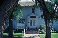
The Historic McLean County Courthouse, which is now a museum.
See also
 In Spanish: Condado de McLean (Dakota del Norte) para niños
