White Shield, North Dakota facts for kids
Quick facts for kids
White Shield, North Dakota
|
|
|---|---|

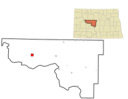
Location of White Shield, North Dakota
|
|
| Country | United States |
| State | North Dakota |
| County | McLean |
| Area | |
| • Total | 3.80 sq mi (9.83 km2) |
| • Land | 3.80 sq mi (9.83 km2) |
| • Water | 0.00 sq mi (0.00 km2) |
| Elevation | 1,992 ft (607 m) |
| Population
(2020)
|
|
| • Total | 363 |
| • Density | 95.63/sq mi (36.92/km2) |
| Time zone | UTC-6 (Central (CST)) |
| • Summer (DST) | UTC-5 (CDT) |
| ZIP code |
58540
|
| Area code(s) | 701 |
| FIPS code | 38-85660 |
| GNIS feature ID | 2393855 |
White Shield is a small community in North Dakota, United States. It is a census-designated place (CDP). This means it is a special area defined by the government for counting people.
White Shield is located on the Fort Berthold Indian Reservation. This reservation is home to the Mandan, Hidatsa, and Arikara Nation. The community is in McLean County. In 2020, about 363 people lived there.
White Shield is very important to the Arikara (Sahnish) people. It is seen as their main community. The town is named after a famous Arikara leader, Chief White Shield.
White Shield was created in 1954. It was built to replace an older town called Elbowoods. Elbowoods was flooded when Lake Sakakawea was formed. Lake Sakakawea is a large reservoir. Chief White Shield was an Arikara chief. He also worked as a scout for General George Armstrong Custer.
Contents
About White Shield's Land
White Shield covers an area of about 3.8 square miles (9.8 square kilometers). All of this area is land. There are no large bodies of water within the community's boundaries.
Culture and Language
The Arikara language is a very important part of White Shield's culture. As of 2014, people in White Shield are working hard to keep the Arikara language alive. This effort is called language revitalization.
The Arikara language is taught in several places. Students can learn it at Fort Berthold Community College. It is also taught at White Shield School. The Arikara Cultural Center helps teach the language too. These efforts help younger generations learn and use their traditional language.
People of White Shield
The number of people living in White Shield has changed over the years.
- In 1990, there were 274 people.
- In 2000, the population grew to 348.
- In 2010, it was 336 people.
- By 2020, the population was 363.
Most people living in White Shield are Native American. In 2000, about 98.56% of the people were Native American. A small number of people were White. Some people were from two or more racial groups. About 11.78% of the population identified as Hispanic or Latino.
In 2000, the average age of people in White Shield was 23 years old. A large part of the population was under 18 years old. About 43.1% of residents were children and teenagers.
Education in White Shield
The community of White Shield is served by the White Shield School District. This district provides education for the children living in the area.
Notable People from White Shield
- Carol Juneau is an important person from this area. She is an American politician from Montana. She used to be a member of the Montana House of Representatives. She also served in the Montana Senate. Carol Juneau was born in Elbowoods, the town that White Shield replaced.
See also
 In Spanish: White Shield (Dakota del Norte) para niños
 | Precious Adams |
 | Lauren Anderson |
 | Janet Collins |


