Fort Berthold Indian Reservation facts for kids
Quick facts for kids
Fort Berthold Indian Reservation
|
||
|---|---|---|
|
||

Location in North Dakota
|
||
| Tribe | Mandan, Hidatsa, and Arikara Nation | |
| Country | United States | |
| State | North Dakota | |
| Counties | Dunn McKenzie McLean Mercer Mountrail Ward |
|
| Headquarters | New Town | |
| Government | ||
| • Body | Three Affiliated Tribes Business Council | |
| Population
(2017)
|
||
| • Total | 7,304 | |
| Website | mhanation.com | |
The Fort Berthold Indian Reservation is a special area of land in western North Dakota. It's the home of the federally recognized Mandan, Hidatsa, and Arikara Nation, also known as the Three Affiliated Tribes. This reservation includes land on both sides of the Missouri River.
This reservation was created in 1870. It is only a small part of the much larger lands that were originally set aside for these tribes. These original lands were part of the Fort Laramie Treaty of 1851. That treaty gave the tribes nearly 12 million acres (49,000 km²) across several states. These states included North Dakota, South Dakota, Montana, Nebraska, and Wyoming.
Contents
Where is Fort Berthold Reservation?
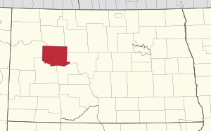
The Fort Berthold Indian Reservation is located along the Missouri River. It spans across several counties in North Dakota. These counties are McLean, Mountrail, Dunn, McKenzie, Mercer, and Ward.
The reservation covers about 988,000 acres (4,000 km²). A large part of this land, about 457,837 acres (1,853 km²), is owned by Native Americans. This land is either owned by individual families or by the tribe as a whole. The McLean National Wildlife Refuge is also located within the reservation's borders.
A very important bridge, the Four Bears Bridge, helps people cross Lake Sakakawea. This bridge opened in 2005, replacing an older one from 1955.
History of the Reservation
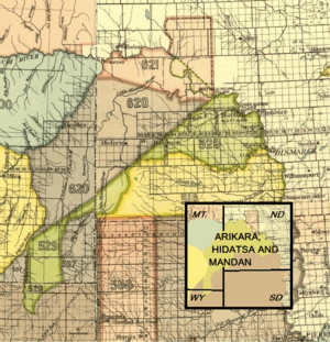
The Fort Berthold Indian Reservation is part of the land that the Three Tribes were recognized to own in the Treaty of Fort Laramie (1851).
The U.S. government created the reservation in 1870. It was named after Fort Berthold, which was a United States Army fort. This fort was located on the northern bank of the Missouri River. It was about twenty miles downstream from where the Little Missouri River joins the Missouri.
Over time, the size of the reservation changed. For example, in 1870, some land became U.S. territory. But other areas, like parts of areas 620 and 621 south of the Missouri River, stayed with the Native Americans. The U.S. government also recognized the tribes' right to the land where their homes were in Like-a-Fishhook Village.
Later, in 1880, the tribes' land was reduced. However, they did gain some extra land north of the Missouri River. In 1886, the tribes agreed to give up land outside a specific rectangular area. This area was marked with black dots and strokes on maps.
Changes to Land Ownership
In the late 1800s and early 1900s, the U.S. government passed laws like the Dawes Act. These laws changed how Native American tribes owned land. Instead of tribes owning land together, the government tried to give individual plots of land to families. The idea was to encourage tribal members to farm in the same way European-Americans did.
Even with these changes, the tribe kept some of its land as shared property. Since they reorganized in the 1930s, the tribe has worked to keep their land together. They have resisted breaking up all their land into individual plots.
Population and Economy
In 2010, about 6,341 people lived on the reservation. By March 2016, the Tribe reported that 15,013 people were officially registered members. Many tribal members live in cities because there are more job opportunities there. At one point, about 42% of people on the reservation were unemployed.
A big change happened between 1947 and 1953 with the building of the Garrison Dam. This dam created Lake Sakakawea in 1956. The lake was built to help with irrigation, control floods, and produce electricity. However, creating this large lake flooded huge areas of tribal land. Much of this land was used for farming and raising animals. This flooding greatly harmed the economy of the Three Affiliated Tribes.
Communities on the Reservation
The largest towns on the Fort Berthold Indian Reservation are New Town and Parshall. The tribe also runs the 4 Bears Casino and Lodge in New Town, which was built in 1993.
Here are some of the communities located on the reservation:
 | Delilah Pierce |
 | Gordon Parks |
 | Augusta Savage |
 | Charles Ethan Porter |


