
Mandaree, North Dakota facts for kids
Quick facts for kids
Mandaree, North Dakota
Adixoodagoorahareesh
|
|
|---|---|

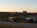
Street in Mandaree
|
|

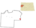
Location of Mandaree, North Dakota
|
|
| Country | United States |
| State | North Dakota |
| County | McKenzie |
| Area | |
| • Total | 11.15 sq mi (28.87 km2) |
| • Land | 11.13 sq mi (28.84 km2) |
| • Water | 0.01 sq mi (0.03 km2) |
| Elevation | 2,257 ft (688 m) |
| Population
(2020)
|
|
| • Total | 691 |
| • Density | 62.06/sq mi (23.96/km2) |
| Time zone | UTC-6 (Central (CST)) |
| • Summer (DST) | UTC-5 (CDT) |
| ZIP code |
58757
|
| Area code(s) | 701 |
| FIPS code | 38-49980 |
| GNIS feature ID | 2393116 |
Mandaree is a community in McKenzie County, North Dakota, United States. It is known as Adixoodagoorahareesh in the Hidatsa language. Mandaree is a special kind of place called a census-designated place (CDP). This means it's an area the government counts for population, but it doesn't have its own city government. In 2020, about 691 people lived there.
Mandaree is located on the Fort Berthold Indian Reservation. This reservation is home to the Mandan, Hidatsa, and Arikara Native American tribes.
Contents
History of Mandaree
Mandaree was founded in 1954. Many people moved here because their original homes were flooded. This happened when the Garrison Dam was built, causing the water levels to rise.
How Mandaree Got Its Name
The name "Mandaree" was suggested by a Catholic missionary on the reservation. It's a mix of the names of the three tribes who live there. It comes from Mandan, Hidatsa, and Ree (another name for the Arikara).
Community Life
Mandaree is a very important place for the Mandan-Hidatsa community. It serves as a main gathering spot for the tribes.
Annual Pow-wow
Mandaree is famous across the country for its yearly Pow-wow. This special event happens on the second weekend of July. Pow-wows are traditional Native American gatherings that include dancing, singing, and celebrating culture.
Mandaree Singers
The community is also home to the Mandaree Singers. This is a well-known tribal musical group. They share traditional songs and music.
Geography
Mandaree is located in North Dakota. According to the United States Census Bureau, the community covers a total area of about 11.2 square miles (28.87 square kilometers). Most of this area is land, with a very small amount of water.
Population Information
The population of Mandaree has grown over the years:
- 1990: 367 people
- 2000: 558 people
- 2010: 596 people
- 2020: 691 people
In 2000, most people living in Mandaree were Native American (about 95.88%). A small percentage were White or from other backgrounds. The community had many families with children. The average age of people living in Mandaree was 18 years old.
Education
Mandaree has its own school district, called Mandaree Public School District #36. This district includes Mandaree Elementary School and Mandaree High School. Both schools get money from the Bureau of Indian Education (BIE) and the state of North Dakota. The school sports teams are known as the "Mandaree Warriors" and "Lady Warriors."
In 2019, a new center called the Crestwood Maagarishda Center opened. It cost $2.3 million to build. This center includes a Head Start program, which helps young children get ready for school.
Notable People
Some well-known people from Mandaree include:
- Tex G. Hall, who was a tribal chairman.
- Edward Lone Fight, who was also a tribal chairman from 1986 to 1990.
Images for kids
-
Street in Mandaree
-
Location of Mandaree, North Dakota
See also
 In Spanish: Mandaree (Dakota del Norte) para niños
