
Garrison Dam facts for kids
Quick facts for kids Garrison Dam |
|
|---|---|

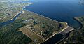
Aerial view from the southeast, impounding Lake Sakakawea on the Missouri River
|
|


Location in the United States##Location in North Dakota
|
|
| Country | United States |
| Location | McLean/Mercer counties, North Dakota |
| Coordinates | 47°29′55″N 101°24′43″W / 47.49861°N 101.41194°W |
| Status | Operational |
| Construction began | 1947 |
| Opening date | 1953 |
| Construction cost | $300 million |
| Owner(s) | U.S. Army Corps of Engineers, Omaha District |
| Dam and spillways | |
| Type of dam | Embankment, rolled earth-fill |
| Impounds | Missouri River |
| Height | 210 ft (64 m) |
| Length | 11,300 ft (3,444 m) |
| Elevation at crest | 1,854 feet (565 m) msl |
| Width (crest) | 60 ft (18 m) |
| Width (base) | 0.5 mi (0.8 km) |
| Dam volume | 66,500,000 cu yd (50,843,000 m3) |
| Spillway type | Service, 28 controlled-gates |
| Spillway capacity | 660,000 cu ft/s (18,700 m3/s) |
| Reservoir | |
| Creates | Lake Sakakawea |
| Total capacity | 23,821,000 acre⋅ft (29.383 km3) |
| Catchment area | 123,900 m2 (1,334,000 sq ft) |
| Surface area | 382,000 acres (1,550 km2) |
| Maximum length | 178 mi (286 km) |
| Maximum water depth | 180 ft (55 m) |
| Normal elevation | 1,854 ft (565 m) (max) |
| Power station | |
| Operator(s) | U.S. Army Corps of Engineers |
| Commission date | January 1956–October 1960 |
| Turbines | 3 x 121.6 MW, 2 x 109.25 Francis type |
| Installed capacity | 583.3 MW |
| Annual generation | 2,250 GWh (1967-2009 Average) |
The Garrison Dam is a huge embankment dam built on the Missouri River in central North Dakota, USA. It's like a giant wall made of earth! The U.S. Army Corps of Engineers built it between 1947 and 1953. At over 2 miles (3.2 km) long, it's one of the largest earthen dams in the world.
The dam creates a huge lake called Lake Sakakawea. This lake stretches all the way to Williston. Building the dam meant that a large part of the Fort Berthold Indian Reservation was flooded. This caused many Three Affiliated Tribes families to lose their homes and farms.
Contents
Where is the Garrison Dam Located?
The Garrison Dam is found between the towns of Riverdale and Pick City. It's named after the town of Garrison, which is just north of the dam across the lake. The dam is about halfway between the cities of Bismarck and Minot. It's also about 10 miles (16 km) west of U.S. Highway 83.
Building the Dam: A Look at its History

The Garrison Dam was part of a big project called the Pick-Sloan Project. This project aimed to control floods and create hydroelectric power along the Missouri River. It was named after its two main planners, Colonel Lewis A. Pick and William Glenn Sloan.
Local communities didn't want the dam built in places where it would affect them. So, the chosen spot was where the Garrison Dam now stands.
Impact on Native American Tribes
To build the dam, the US government needed to buy a lot of land. About 152,360 acres (617 km²) of land in the Fort Berthold Reservation would be flooded by the new Lake Sakakawea. This land belonged to the Three Affiliated Tribes. They had lived there for over a thousand years.
The tribes protested because they were forced to sell their land. They were worried about losing their homes and way of life. In 1947, they had to accept $5,105,625 for their land. This amount was later increased to $7.5 million in 1949. However, it still wasn't enough to make up for losing their important farmlands, homes, towns, and burial sites. These bottomlands were very important for their farming, which helped them be self-sufficient.
The final agreement also stopped the tribes from using the lake's shoreline for their traditional activities. These included grazing animals, hunting, fishing, or developing irrigation. About 1,700 people were forced to move. Some moved to New Town, North Dakota, at the northern end of the reservation.
Building the Garrison Dam greatly changed the traditional way of life for the Three Affiliated Tribes. It made them more reliant on the government. The huge size of the lake also made it hard for people to travel and connect with each other for many years.
Construction and Dedication
Construction on the Garrison Dam began in 1947. The project cost about $300 million. The main part of the dam was finished in April 1953. Just two months later, President Eisenhower officially opened the dam. The U.S. Army Corps of Engineers finished all the earthwork in the fall of 1954.
Missouri River Dam System
The Garrison Dam is one of six major dams on the Missouri River. The U.S. Army Corps of Engineers manages all of them. The dam upstream from Garrison Dam is Fort Peck Dam in Montana. The dams downstream are:
- Oahe Dam (near Pierre, South Dakota)
- Big Bend Dam (near Fort Thompson, South Dakota)
- Fort Randall Dam (near Pickstown, South Dakota)
- Gavins Point Dam (near Yankton, South Dakota)
Together, these six dams create huge reservoirs. They can hold about 73,129,000 acre-feet (90.2 km³) of water. They also cover about 1,111,884 acres (4,500 km²) of water surface.
In June 2011, during major floods on the Missouri River, the Garrison Dam released a record amount of water. It let out over 140,000 cubic feet per second (4,000 m³/s). This was much more than its previous record of 65,000 cubic feet per second (1,800 m³/s) set in 1997. The dam's emergency spillway was used for the first time on June 1, 2011.
Generating Clean Energy at Garrison Dam
The Garrison Dam has special machines called hydropower turbines. These turbines use the force of the water to create electricity. They can produce up to 583.3 MW of power. On average, they produce 257 MW, which is enough electricity for hundreds of thousands of homes and businesses.
Fun Activities and Wildlife at the Dam
The Garrison Dam area is great for outdoor activities!
Fishing and Fish Hatchery
The Garrison Dam National Fish Hatchery is a very important place. It's the largest facility in the world for raising walleye and northern pike. It also works to help bring back endangered fish species, like the pallid sturgeon.
Hiking and Trails
A part of the North Country National Scenic Trail goes through the National Fish Hatchery. This trail also includes a section along the Missouri River shoreline. On this part, hikers are also on the Lewis & Clark National Historic Trail. It's a great way to explore nature and history at the same time!
Images for kids
-
Aerial view from the southeast, impounding Lake Sakakawea on the Missouri River
-
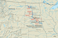
Dams and reservoirs in the Pick–Sloan Program, and affected Indian reservations.
See also
 In Spanish: Presa Garrison para niños
