Butte, North Dakota facts for kids
Quick facts for kids
Butte, North Dakota
|
|
|---|---|

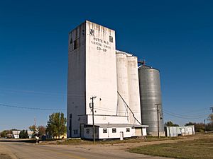
Grain Elevator in Butte
|
|

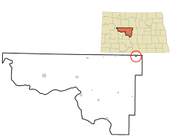
Location of Butte, North Dakota
|
|
| Country | United States |
| State | North Dakota |
| County | McLean |
| Founded | 1906 |
| Area | |
| • Total | 0.25 sq mi (0.64 km2) |
| • Land | 0.25 sq mi (0.64 km2) |
| • Water | 0.00 sq mi (0.00 km2) |
| Elevation | 1,742 ft (531 m) |
| Population
(2020)
|
|
| • Total | 70 |
| • Estimate
(2022)
|
67 |
| • Density | 284.55/sq mi (109.99/km2) |
| Time zone | UTC-6 (Central (CST)) |
| • Summer (DST) | UTC-5 (CDT) |
| ZIP code |
58723
|
| Area code(s) | 701 |
| FIPS code | 38-11180 |
| GNIS feature ID | 1035948 |
Butte is a small city in McLean County, North Dakota, in the United States. It was founded in 1906. In 2020, about 70 people lived there.
Contents
Where is Butte Located?
Butte is located in the state of North Dakota. The city covers a total area of about 0.25 square miles (0.64 square kilometers). All of this area is land.
How Many People Live in Butte?
The number of people living in Butte has changed over the years. In 1910, there were 320 residents. By 2020, the population was 70 people.
| Historical population | |||
|---|---|---|---|
| Census | Pop. | %± | |
| 1910 | 320 | — | |
| 1920 | 252 | −21.2% | |
| 1930 | 231 | −8.3% | |
| 1940 | 261 | 13.0% | |
| 1950 | 272 | 4.2% | |
| 1960 | 257 | −5.5% | |
| 1970 | 193 | −24.9% | |
| 1980 | 157 | −18.7% | |
| 1990 | 129 | −17.8% | |
| 2000 | 92 | −28.7% | |
| 2010 | 68 | −26.1% | |
| 2020 | 70 | 2.9% | |
| 2022 (est.) | 67 | −1.5% | |
| U.S. Decennial Census 2020 Census |
|||
Butte's Population in 2010
In 2010, 68 people lived in Butte. There were 40 households in the city. Most people living in Butte were White.
Many households (55%) had only one person living in them. About 25% of households had someone aged 65 or older living alone. The average age of people in Butte was about 60 years old.
Education in Butte
Students in Butte attend schools that are part of the Velva Public School District 1.
See also
 In Spanish: Butte (Dakota del Norte) para niños
 | Tommie Smith |
 | Simone Manuel |
 | Shani Davis |
 | Simone Biles |
 | Alice Coachman |

