
Oliver County, North Dakota facts for kids
Quick facts for kids
Oliver County
|
|
|---|---|
.jpg)
|
|

Location within the U.S. state of North Dakota
|
|
 North Dakota's location within the U.S. |
|
| Country | |
| State | |
| Founded | April 14, 1885 (created) May 18, 1885 (organized) |
| Named for | Harry S. Oliver |
| Seat | Center |
| Largest city | Center |
| Area | |
| • Total | 731 sq mi (1,890 km2) |
| • Land | 723 sq mi (1,870 km2) |
| • Water | 8.7 sq mi (23 km2) 1.2% |
| Population
(2020)
|
|
| • Total | 1,877 |
| • Estimate
(2022)
|
1,856 |
| • Density | 2.5677/sq mi (0.9914/km2) |
| Time zone | UTC−6 (Central) |
| • Summer (DST) | UTC−5 (CDT) |
| Congressional district | At-large |
Oliver County is a county located in the U.S. state of North Dakota. As of the 2020 census, the population was 1,877 people. Its county seat and only city is Center.
Contents
History of Oliver County
Oliver County was created on April 14, 1885. The government of Dakota Territory made the county from a part of Mercer County.
The county was named after Harry S. Oliver. He was a politician from Lisbon, North Dakota. He was a member of the Dakota Territory House of Representatives at that time.
The county government officially started on May 18, 1885. Sanger was the first county seat. Back then, Sanger was known as "Bentley." In 1902, the county seat moved to Center.
Oliver County is part of the Bismarck area. This area is known as the Bismarck–Mandan Metropolitan Statistical Area.
Geography of Oliver County
The Missouri River forms the northeastern and eastern border of Oliver County. The river flows southeast after leaving Lake Sakakawea.
The land in the county has rolling hills. Most of this land is used for farming. The land slopes down towards the east. The highest point is a hill in the southwestern part of the county. It is about 2,382 feet (726 meters) above sea level.
Oliver County covers a total area of 731 square miles (1,893 square kilometers). About 723 square miles (1,873 square kilometers) is land. The remaining 8.7 square miles (23 square kilometers) is water. This means about 1.2% of the county is water. It is the fifth-smallest county in North Dakota by land area.
The county seat, Center, is named because it is near the middle of the county. By chance, Center has also been found to be the geographic center of North America!
Main Roads in Oliver County
 North Dakota Highway 25
 North Dakota Highway 31
 North Dakota Highway 48
 North Dakota Highway 200A
 North Dakota Highway 1806
Counties Near Oliver County
- McLean County - northeast
- Burleigh County - east
- Morton County - south
- Mercer County - northwest
Parks and Lakes in Oliver County
- Cross Ranch State Park
- Mandan Lake
- Nelson Lake
Population of Oliver County
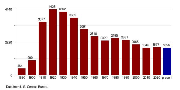
| Historical population | |||
|---|---|---|---|
| Census | Pop. | %± | |
| 1890 | 464 | — | |
| 1900 | 990 | 113.4% | |
| 1910 | 3,577 | 261.3% | |
| 1920 | 4,425 | 23.7% | |
| 1930 | 4,262 | −3.7% | |
| 1940 | 3,859 | −9.5% | |
| 1950 | 3,091 | −19.9% | |
| 1960 | 2,610 | −15.6% | |
| 1970 | 2,322 | −11.0% | |
| 1980 | 2,495 | 7.5% | |
| 1990 | 2,381 | −4.6% | |
| 2000 | 2,065 | −13.3% | |
| 2010 | 1,846 | −10.6% | |
| 2020 | 1,877 | 1.7% | |
| 2022 (est.) | 1,856 | 0.5% | |
| U.S. Decennial Census 1790-1960 1900-1990 1990-2000 2010-2020 |
|||
2020 Census Information
According to the census in 2020, Oliver County had 1,877 people.
2010 Census Information
In 2010, the county had 1,846 people. There were 756 households and 554 families. The population density was about 2.55 people per square mile.
Most people in the county were white (97.3%). About 1.5% were American Indian. People of Hispanic or Latino origin made up 1.0% of the population.
Many people in Oliver County have German roots (66.8%). Others have Norwegian (19.3%), Russian (7.6%), or English (6.3%) backgrounds.
The average household had 2.44 people. The average family had 2.84 people. The average age in the county was 47.6 years old.
Population Changes Over Time
Communities in Oliver County
City in Oliver County
- Center (This is the county seat.)
Unincorporated Communities
These are smaller towns or places that do not have their own local government.
- Fort Clark
- Hannover
- Hensler
- Price
- Sanger (This town was first called "Bentley.")
Education in Oliver County
Students in Oliver County attend schools in several different districts:
- Beulah Public School District 27
- Center-Stanton Public School District 1
- Glen Ullin Public School District 48
- Hazen Public School District 3
- New Salem-Almont School District
- Washburn Public School District 4
The town of Center used to have its own school district. But in 2004, it joined with Stanton's school district. Now they are one district.
See also
 In Spanish: Condado de Oliver (Dakota del Norte) para niños
