
Morton County, North Dakota facts for kids
Quick facts for kids
Morton County
|
|
|---|---|

Morton County Courthouse in Mandan
|
|

Location within the U.S. state of North Dakota
|
|
 North Dakota's location within the U.S. |
|
| Country | |
| State | |
| Founded | January 8, 1873 (created) March 27, 1896 (present configuration) |
| Named for | Oliver P. Morton |
| Seat | Mandan |
| Largest city | Mandan |
| Area | |
| • Total | 1,945 sq mi (5,040 km2) |
| • Land | 1,926 sq mi (4,990 km2) |
| • Water | 19 sq mi (50 km2) 1.0% |
| Population
(2020)
|
|
| • Total | 33,291 |
| • Estimate
(2023)
|
33,895 |
| • Density | 17.116/sq mi (6.6086/km2) |
| Time zone | UTC−6 (Central) |
| • Summer (DST) | UTC−5 (CDT) |
| Congressional district | At-large |
Morton County is a county located in the state of North Dakota, USA. As of the 2020 census, about 33,291 people lived there. This makes it the sixth most populated county in North Dakota. The main city and county seat is Mandan. Morton County is part of the larger Bismarck Metropolitan Statistical Area.
Contents
Early History of Morton County
Morton County was first created on January 8, 1873, by the government of the Dakota Territory. At first, the county was not fully organized. Its organization was completed on November 5, 1878. The county was named after Oliver Hazard Perry Throck Morton. He was a governor of Indiana during the American Civil War and later a U.S. Senator.
The county's borders changed a few times in the 1880s. In 1916, a part of Morton County was used to create Grant County. This set Morton County's borders to how they are today.
After the Northern Pacific Railroad announced where its bridge over the Missouri River would be, a new town started in December 1878. This town was first called "Morton." Later, the town was renamed Mandan, and it became the county seat.
Recent Events in Morton County
Dakota Access Pipeline Protests
The Dakota Access Pipeline (DAPL) is a long pipeline that carries oil. About 72 miles of its route goes through Morton County. In April 2016, Morton County became a main spot for protests against the pipeline.
The Standing Rock Sioux Tribe (SRST) was concerned about the pipeline. They tried to stop its construction in court in August 2016. They were worried about possible water contamination. However, the court denied their request to stop the construction.
A group called Amnesty International asked the Morton County sheriff to look into how private security guards were acting during the protests. This was after reports of security guards using dogs and pepper spray on protesters in September 2016. Later, in November, police used water from fire hoses and other methods to control protesters in very cold weather.
Geography of Morton County
The Missouri River flows along the eastern border of Morton County. The Cannonball River flows along the southeastern part of the county's southern border. The land in the county has rolling hills and valleys. Many flatter areas are used for farming. The highest point in the county is about 2,375 feet (724 meters) above sea level. Morton County covers a total area of 1,945 square miles (5,037 square kilometers). Of this, 1,926 square miles (4,988 square kilometers) is land and 19 square miles (49 square kilometers) is water.
Major Roads
 Interstate 94
 North Dakota Highway 6
 North Dakota Highway 21
 North Dakota Highway 25
 North Dakota Highway 31
 North Dakota Highway 49
 North Dakota Highway 1806
Public Transportation
- Bis-Man Transit
Neighboring Counties
- Oliver County - north
- Burleigh County - northeast
- Emmons County - east
- Sioux County - southeast
- Grant County - south
- Stark County - west
- Mercer County - northwest
Protected Natural Areas
- Lake Patricia National Wildlife Refuge
- Morton County State Game Management Area
- Storm Creek State Game Management Area
- Sweet Briar Dam State Game Management Area
Lakes in Morton County
- Crown Butte Lake
- Fish Creek Lake
- Harmon Lake
- Lake Oahe (part)
- Lake Patricia
- Storm Creek Lake
- Sweet Briar Lake
Population Information
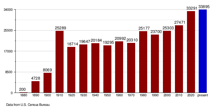
| Historical population | |||
|---|---|---|---|
| Census | Pop. | %± | |
| 1880 | 200 | — | |
| 1890 | 4,728 | 2,264.0% | |
| 1900 | 8,069 | 70.7% | |
| 1910 | 25,289 | 213.4% | |
| 1920 | 18,714 | −26.0% | |
| 1930 | 19,647 | 5.0% | |
| 1940 | 20,184 | 2.7% | |
| 1950 | 19,295 | −4.4% | |
| 1960 | 20,992 | 8.8% | |
| 1970 | 20,310 | −3.2% | |
| 1980 | 25,177 | 24.0% | |
| 1990 | 23,700 | −5.9% | |
| 2000 | 25,303 | 6.8% | |
| 2010 | 27,471 | 8.6% | |
| 2020 | 33,291 | 21.2% | |
| 2023 (est.) | 33,895 | 23.4% | |
| U.S. Decennial Census 1790-1960 1900-1990 1990-2000 2010-2020 |
|||
2020 Census Details
In 2020, the census counted 33,291 people living in Morton County. There were 13,827 households and 8,617 families. The population density was about 17.3 people per square mile (6.7 people per square kilometer). There were also 15,107 housing units.
2010 Census Details
According to the 2010 census, there were 27,471 people in the county. There were 11,289 households and 7,523 families. The population density was about 14.3 people per square mile. Most people (93.6%) were white, and 3.6% were American Indian. About 1.5% of the population was of Hispanic or Latino origin.
The average household had 2.38 people, and the average family had 2.90 people. The median age in the county was 39.3 years.
Population Changes Over Time
Communities in Morton County


Cities
Census-Designated Place
Unincorporated Communities
These are smaller communities that are not officially organized as cities or towns.
- Bluegrass
- Breien
- Eagle Nest
- Fallon
- Fort Rice
- Huff
- Judson
- Rock Haven
- St. Anthony
- Sims
- Solen
- Sweet Briar
- Timmer
- Youngstown
Township
- Captain's Landing
See also
 In Spanish: Condado de Morton (Dakota del Norte) para niños
