
Sioux County, North Dakota facts for kids
Quick facts for kids
Sioux County
|
|
|---|---|
.jpg)
Postcard. Historic Sioux County Courthouse at Fort Yates, North Dakota.
|
|

Location within the U.S. state of North Dakota
|
|
 North Dakota's location within the U.S. |
|
| Country | |
| State | |
| Founded | September 3, 1914 (created) September 12, 1914 (organized) |
| Named for | Sioux people |
| Seat | Fort Yates |
| Largest community | Cannon Ball |
| Area | |
| • Total | 1,128 sq mi (2,920 km2) |
| • Land | 1,094 sq mi (2,830 km2) |
| • Water | 34 sq mi (90 km2) 3.0% |
| Population
(2020)
|
|
| • Total | 3,898 |
| • Estimate
(2022)
|
3,711 |
| • Density | 3.4557/sq mi (1.3342/km2) |
| Time zones | |
| (eastern portion) | UTC−6 (Central) |
| • Summer (DST) | UTC−5 (CDT) |
| (western portion) | UTC−7 (Mountain) |
| • Summer (DST) | UTC−6 (MDT) |
| Congressional district | At-large |
Sioux County is a special place in North Dakota, located right on its southern edge. It's known for its beautiful natural areas and rich history. In 2020, about 3,898 people lived here. The mighty Missouri River forms its eastern border, and the main town, or 'county seat,' is Fort Yates.
Contents
History of Sioux County
Sioux County was officially started by Governor Louis B. Hanna on September 3, 1914. It was named after the Lakota people, a Native American group who lived in this area for a long time. The county government began working on September 12 of the same year.
This county is unique because it is entirely inside the Standing Rock Indian Reservation. This reservation also stretches into South Dakota. Sioux County is the only county in North Dakota that is completely within a Native American reservation. For a few years, from 2013 to 2018, Sioux County was part of the larger Bismarck area for planning purposes.
Geography and Nature
Sioux County is located on the southern border of North Dakota, right next to South Dakota. To the north, the Cedar Creek flows east into the Missouri River. The Missouri River itself forms the county's eastern border, creating part of Lake Oahe. Another creek, Porcupine Creek, also flows into the Missouri River, helping to drain the northeastern part of the county.
The land in Sioux County has gentle, rolling hills with small valleys and streams. Most of the area is used for farming. The land generally slopes down towards the east and south. The highest point is on the western side, reaching about 2,602 feet (793 meters) above sea level. The county covers a total area of 1,128 square miles (2,922 square kilometers). About 1,094 square miles (2,833 square kilometers) is land, and 34 square miles (88 square kilometers) is water.
Some parts of North Dakota, especially in the southwest, use Mountain Time. Sioux County is one of the counties that is split, with its western parts observing Mountain Time.
Main Roads in Sioux County
 North Dakota Highway 6
 North Dakota Highway 24
 North Dakota Highway 31
 North Dakota Highway 49
 North Dakota Highway 1806
Neighboring Counties
- Morton County - north (uses Central Time)
- Emmons County - east (uses Central Time)
- Corson County, South Dakota - south (uses Mountain Time)
- Adams County - west (uses Mountain Time)
- Grant County - northwest (uses Mountain Time)
Protected Natural Areas
- Cedar River National Grassland (part of it)
- Froelich Dam State Game Management Area
Population and People
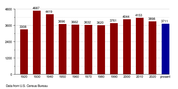
| Historical population | |||
|---|---|---|---|
| Census | Pop. | %± | |
| 1920 | 3,308 | — | |
| 1930 | 4,687 | 41.7% | |
| 1940 | 4,419 | −5.7% | |
| 1950 | 3,696 | −16.4% | |
| 1960 | 3,662 | −0.9% | |
| 1970 | 3,632 | −0.8% | |
| 1980 | 3,620 | −0.3% | |
| 1990 | 3,761 | 3.9% | |
| 2000 | 4,044 | 7.5% | |
| 2010 | 4,153 | 2.7% | |
| 2020 | 3,898 | −6.1% | |
| 2022 (est.) | 3,711 | −10.6% | |
| U.S. Decennial Census 1790-1960 1900-1990 1990-2000 2010-2020 |
|||
What the 2020 Census Shows
The census is like a big count of all the people living in an area. In 2020, the census found that 3,898 people lived in Sioux County.
Looking Back at the 2010 Census
In 2010, there were 4,153 people living in Sioux County. There were 1,158 households (groups of people living together) and 900 families. The county had about 3.8 people per square mile.
Most of the people in the county were Native Americans, making up 84.1% of the population. About 12.6% were white. A small number of people were from other racial backgrounds or a mix of two or more races. About 2.0% of the population was of Hispanic or Latino origin.
Many households (54.1%) had children under 18 living with them. The average household had about 3.55 people, and the average family had about 3.89 people. The average age of people in the county was 26.3 years old.
Population Changes Over Time
Towns and Communities
Cities in Sioux County
- Fort Yates (This is the main town, or county seat)
- Selfridge
- Solen
Special Census-Designated Places
These are areas that are like towns but not officially incorporated as cities.
Township
- Menz
Education in Sioux County
Kids in Sioux County go to schools in these districts:
- Fort Yates Public School District 4 (works with the Standing Rock Bureau of Indian Education (BIE) school)
- Selfridge Public School District 8
- Solen Public School District 3
See also
 In Spanish: Condado de Sioux (Dakota del Norte) para niños
