
Adams County, North Dakota facts for kids
Quick facts for kids
Adams County
|
|
|---|---|
.jpg)
Postcard. Adams County Courthouse in Hettinger
|
|

Location within the U.S. state of North Dakota
|
|
 North Dakota's location within the U.S. |
|
| Country | |
| State | |
| Founded | April 17, 1907 (created) April 24, 1907 (organized) |
| Seat | Hettinger |
| Largest city | Hettinger |
| Area | |
| • Total | 989 sq mi (2,560 km2) |
| • Land | 988 sq mi (2,560 km2) |
| • Water | 1.1 sq mi (3 km2) 0.1% |
| Population
(2020)
|
|
| • Total | 2,200 |
| • Estimate
(2022)
|
2,115 |
| • Density | 2.22/sq mi (0.859/km2) |
| Time zone | UTC−7 (Mountain) |
| • Summer (DST) | UTC−6 (MDT) |
| Congressional district | At-large |
Adams County is a place in the state of North Dakota in the United States. It's like a big district or area within the state. In 2020, about 2,200 people lived there. The main town, or county seat, is Hettinger.
Adams County was officially created on April 17, 1907. It was named after John Quincy Adams, who worked for a railroad company. He was also a distant relative of an earlier U.S. President, also named John Quincy Adams.
In 1923, a very strong tornado hit Adams County. It was called the "Adams County Twister." This tornado was one of the most dangerous in North Dakota's history. It caused eight deaths and injured 20 people.
Geography of Adams County
Adams County is located in the southern part of North Dakota. Its southern border touches the state of South Dakota. The land here has low, rolling hills and is a bit dry. The highest point in the county is about 3,002 feet (915 meters) above sea level. The county covers a total area of about 989 square miles (2,561 square kilometers). Most of this area is land, with only a small part being water.
Neighboring Counties
Adams County shares its borders with several other counties:
- Hettinger County – to the north
- Grant County – to the northeast
- Sioux County – to the east
- Corson County, South Dakota - to the southeast
- Perkins County, South Dakota – to the south
- Harding County, South Dakota – to the southwest
- Bowman County – to the west
- Slope County – to the northwest
Main Roads
These are the most important roads that go through Adams County:
 U.S. Highway 12
 North Dakota Highway 8
 North Dakota Highway 22
Special Areas
- North Lemmon Lake State Game Management Area is a protected area in the county.
Lakes in Adams County
- North Lemmon Lake
- Mirror Lake
People in Adams County (Demographics)
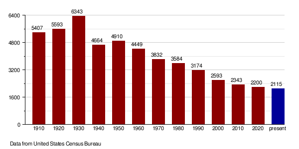
| Historical population | |||
|---|---|---|---|
| Census | Pop. | %± | |
| 1910 | 5,407 | — | |
| 1920 | 5,593 | 3.4% | |
| 1930 | 6,343 | 13.4% | |
| 1940 | 4,664 | −26.5% | |
| 1950 | 4,910 | 5.3% | |
| 1960 | 4,449 | −9.4% | |
| 1970 | 3,832 | −13.9% | |
| 1980 | 3,584 | −6.5% | |
| 1990 | 3,174 | −11.4% | |
| 2000 | 2,593 | −18.3% | |
| 2010 | 2,343 | −9.6% | |
| 2020 | 2,200 | −6.1% | |
| 2022 (est.) | 2,115 | −9.7% | |
| U.S. Decennial Census 1790-1960 1900-1990 1990-2000 2010-2020 |
|||
Population in 2020
According to the census in 2020, there were 2,200 people living in Adams County.
Population in 2010
In 2010, there were 2,343 people living in the county. These people lived in 1,098 households, and 658 of those were families. Most people (97.3%) were white. Other groups included American Indian, Asian, and Black or African American people. About 0.9% of the population was of Hispanic or Latino background.
Many people in Adams County have German (51.8%) or Norwegian (29.9%) ancestors. Other backgrounds include Irish, Swedish, English, Russian, and American.
About 22.3% of households had children under 18 living with them. The average age of people in the county was 49.5 years old.
The average income for a household was about $35,966. For families, it was about $50,227. About 10.6% of all people in the county lived below the poverty line.
How the Population Changed Over Time
Towns and Areas

Cities
These are the main cities in Adams County:
Small Communities (Unincorporated)
These are smaller places that are not officially cities:
Ghost Towns
- Petrel (This place is also considered a ghost town, meaning it used to be more populated but now has very few or no residents.)
Townships
Townships are smaller local government areas within the county:
- Beisigl
- Bucyrus
- Cedar
- Chandler
- Clermont
- Darling Springs
- Duck Creek
- Gilstrap
- Hettinger
- Lightning Creek
- Maine
- Orange
- Reeder
- Scott
- South Fork
- Taylor Butte
- Wolf Butte
Unorganized Areas
These are parts of the county that are not part of any specific township or city:
Former Townships
These townships used to exist but are no longer active:
- Argonne
- Cedar Butte
- Dakota
- Holden
- Holt
- Jordan
- Kansas City
- Lemmon
- North Lemmon
- Spring Butte
- Whetstone
See also
 In Spanish: Condado de Adams (Dakota del Norte) para niños
