
Hettinger County, North Dakota facts for kids
Quick facts for kids
Hettinger County
|
|
|---|---|

Hettinger County Courthouse
|
|

Location within the U.S. state of North Dakota
|
|
 North Dakota's location within the U.S. |
|
| Country | |
| State | |
| Founded | March 9, 1883 (created) April 19, 1907 (organized) |
| Named for | Mathias Hettinger |
| Seat | Mott |
| Largest city | Mott |
| Area | |
| • Total | 1,134 sq mi (2,940 km2) |
| • Land | 1,132 sq mi (2,930 km2) |
| • Water | 1.6 sq mi (4 km2) 0.1% |
| Population
(2020)
|
|
| • Total | 2,489 |
| • Estimate
(2022)
|
2,406 |
| • Density | 2.1949/sq mi (0.8474/km2) |
| Time zone | UTC−7 (Mountain) |
| • Summer (DST) | UTC−6 (MDT) |
| Congressional district | At-large |
Hettinger County (pronounced HET-ing-gər) is a county located in the state of North Dakota in the United States. In 2020, about 2,489 people lived there. The main town and center of the county government is Mott.
You might hear about the city of Hettinger, North Dakota. It's important to know that this city is actually in a different county nearby, called Adams County.
Contents
Discovering Hettinger County's Past
The story of Hettinger County began on March 9, 1883. At that time, the area was part of the Dakota Territory. Lawmakers decided to create the county from a piece of Stark County.
The county was named after Mathias K. Hettinger. He was a banker and an important person from Freeport, Illinois. A lawmaker named Erastus A. Williams chose the name to honor his father-in-law. The town of Mott, located by the Cannonball River, was chosen as the county's main town.
Changes to County Borders
Over the years, the county's borders changed a few times. In 1885 and 1887, some parts of the county were made smaller.
Then, in 1896, the county was actually closed down! But don't worry, it was brought back to life in 1901. This happened because the state's highest court decided it should exist again. When it came back, its borders changed a little bit.
Even after being re-created, Hettinger County didn't have its own government right away. So, for a few years, it was managed by Stark County. This arrangement lasted until April 19, 1907. On that day, Hettinger County finally set up its own government.
A couple of days before that, on April 17, 1907, the southern part of Hettinger County was separated. This new area became Adams County.
Attempts to Make Hettinger County Disappear
People tried several times to get rid of Hettinger County. In 1891, lawmakers in North Dakota wanted to add Hettinger County to Stark County. But the governor, Eli C. D. Shortridge, said no.
They tried again in 1895. Lawmakers passed a plan to add Hettinger County to other counties. Voters in those counties said yes. So, Hettinger County was officially gone on November 3, 1896.
However, a rancher named Wilson L. Richards didn't like this. He sued because he would now have to pay taxes to Stark County. The case went to the North Dakota Supreme Court. In 1899, the court said the law was against the rules (unconstitutional).
Even with this ruling, the county stayed gone for a bit. This was because lawmakers passed a new law. But in 1901, the Supreme Court said this new law was also against the rules. This was because the people in the affected counties didn't get to vote on it, which the state's rules required.

The lawmakers tried one more time in 1903. This time, they let people in Stark County and the unorganized counties of Dunn and Hettinger vote. Most people in Stark and Hettinger counties voted yes. But in Dunn County, just one vote made it a no!
Stark County still tried to say the vote was valid. But North Dakota's rules said each county had to agree. So, the state sued Stark County. In 1905, the Supreme Court again ruled the law was unconstitutional. After this, no one tried to get rid of Hettinger County again.
Exploring Hettinger County's Landscape
The Cannonball River flows through the middle of Hettinger County, moving towards the east and southeast. The land here has rolling hills and is mostly used for farming. It's a bit dry, which means it doesn't get a lot of rain. The highest point in the county is a hill in the northwest corner, which is about 2,897 feet (883 meters) above sea level.
Hettinger County covers a total area of about 1,134 square miles (2,937 square kilometers). Most of this is land, about 1,132 square miles (2,932 square kilometers). Only a small part, about 1.6 square miles (4.1 square kilometers), is water.
Main Roads in Hettinger County
 North Dakota Highway 8
 North Dakota Highway 21
 North Dakota Highway 22
Neighboring Counties
- Stark County (to the north)
- Grant County (to the east)
- Adams County (to the south)
- Slope County (to the west)
Lakes in Hettinger County
- Dry Lake
- Jung Lake
- Larson Lake
People of Hettinger County
| Historical population | |||
|---|---|---|---|
| Census | Pop. | %± | |
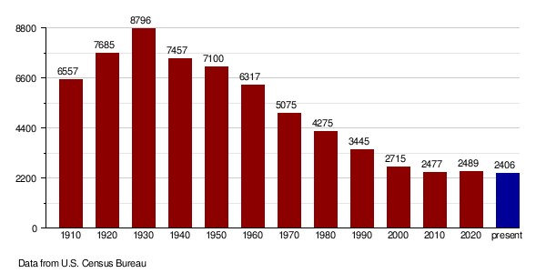
| 1910 | 6,557 | — | |
| 1920 | 7,685 | 17.2% | |
| 1930 | 8,796 | 14.5% | |
| 1940 | 7,457 | −15.2% | |
| 1950 | 7,100 | −4.8% | |
| 1960 | 6,317 | −11.0% | |
| 1970 | 5,075 | −19.7% | |
| 1980 | 4,275 | −15.8% | |
| 1990 | 3,445 | −19.4% | |
| 2000 | 2,715 | −21.2% | |
| 2010 | 2,477 | −8.8% | |
| 2020 | 2,489 | 0.5% | |
| 2022 (est.) | 2,406 | −2.9% | |
| U.S. Decennial Census 1790-1960 1900-1990 1990-2000 2010-2020 |
|||
Population in 2020
According to the census in 2020, there were 2,489 people living in Hettinger County.
Population in 2010
In 2010, the county had 2,477 people. There were 1,056 homes, and 682 of these were families. The population density was about 2.2 people per square mile.
Most people in the county were white (96.2%). About 2.1% were American Indian. People from two or more races made up 1.3%. A small number of people (0.5%) were of Hispanic or Latino background.
Many people in Hettinger County have German roots (71.1%). Other common backgrounds include Norwegian (15.8%), Russian (6.1%), Czech (5.9%), Irish (5.4%), and Hungarian (5.3%).
About 22.4% of homes had children under 18 living there. Most homes (57.6%) were married couples. The average home had 2.19 people, and the average family had 2.75 people. The average age of people in the county was 49.4 years old.
The average income for a home in the county was $38,393. For families, it was $49,605. About 11.0% of all people, and 8.2% of families, lived below the poverty line. This included 9.3% of those under 18 and 13.1% of those aged 65 or older.
How the Population Has Changed Over Time
Towns and Areas in Hettinger County
Cities
- Mott (This is where the county government is located)
- New England
- Regent
Small Communities (Unincorporated)
- Bentley
- Burt
Townships
- Acme
- Ashby
- Baer
- Beery
- Black Butte
- Brittian
- Campbell
- Cannon Ball
- Castle Rock
- Chilton
- Clark
- Farina
- Havelock
- Highland
- Kennedy
- Kern
- Kunze
- Madison
- Merrill
- Mott
- New England
- Odessa
- Rifle
- St. Croix
- Solon
- Steiner
- Strehlow
- Tepee Butte
- Wagendorf
- Walker
Former Townships
- Alden
- Indian Creek Township
Images for kids
-
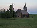
Church building in Bentley
-
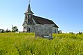
Neuburg Congregational Church


See also
 In Spanish: Condado de Hettinger para niños
